
Newry, Pennsylvania facts for kids
Quick facts for kids
Newry, Pennsylvania
|
|
|---|---|
|
Borough
|
|

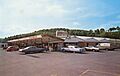
Farmers market
|
|

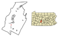
Location of Newry in Blair County, Pennsylvania.
|
|

Newry, Pennsylvania
Location in Pennsylvania
|
|
| Country | United States |
| State | Pennsylvania |
| County | Blair |
| Settled | 1793 |
| Incorporated | 1876 |
| Government | |
| • Type | Borough Council |
| Area | |
| • Total | 0.10 sq mi (0.25 km2) |
| • Land | 0.10 sq mi (0.25 km2) |
| • Water | 0.00 sq mi (0.00 km2) |
| Elevation | 1,050 ft (320 m) |
| Population
(2020)
|
|
| • Total | 230 |
| • Density | 2,346.94/sq mi (905.39/km2) |
| Time zone | UTC-5 (Eastern (EST)) |
| • Summer (DST) | UTC-4 (EDT) |
| Zip code |
16665
|
| Area code(s) | 814 |
| FIPS code | 42-54024 |
| GNIS feature ID | 1214944 |
Newry is a small town, called a borough, in Blair County, Pennsylvania, United States. In 2020, about 231 people lived there. Newry is part of the larger Altoona, PA area.
The town got its name from Newry in Northern Ireland. An Irish immigrant named Patrick Cassidy founded Newry in 1793. He named it after his hometown.
Contents
Exploring Newry's Location
Newry is a very small place. According to the United States Census Bureau, it covers about 0.1 square miles (0.25 square kilometers). All of this area is land.
South of Newry, a stream called Poplar Run flows east. It eventually joins the Frankstown Branch of the Juniata River.
Newry's Changing Population
| Historical population | |||
|---|---|---|---|
| Census | Pop. | %± | |
| 1880 | 326 | — | |
| 1890 | 335 | 2.8% | |
| 1900 | 350 | 4.5% | |
| 1910 | 380 | 8.6% | |
| 1920 | 397 | 4.5% | |
| 1930 | 394 | −0.8% | |
| 1940 | 417 | 5.8% | |
| 1950 | 412 | −1.2% | |
| 1960 | 432 | 4.9% | |
| 1970 | 444 | 2.8% | |
| 1980 | 353 | −20.5% | |
| 1990 | 288 | −18.4% | |
| 2000 | 245 | −14.9% | |
| 2010 | 270 | 10.2% | |
| 2020 | 231 | −14.4% | |
| 2021 (est.) | 235 | −13.0% | |
| Sources: | |||
In 2000, there were 245 people living in Newry. They lived in 107 households, with 61 of these being families. The town had about 2,550 people per square mile.
Most people in Newry were White (97.14%). A small number were African American (0.82%) or from other backgrounds. About 1.22% of the population was Hispanic or Latino.
About 29.9% of households had children under 18. Many households (44.9%) were married couples. About 10.3% were single mothers.
The average household had 2.26 people. Families averaged 3.08 people.
The population had a mix of ages. About 24.9% were under 18. About 13.5% were 65 or older. The average age was 36 years.
The median income for a household was $24,688. For families, it was $39,375. About 14.2% of the population lived below the poverty line.
A Brief History of Newry
Newry was founded in 1793 by Patrick Cassidy. He was an Irish immigrant and a soldier in the American Revolutionary War. He bought 300 acres of land in what is now Blair County. He built a small town there and named it after his hometown in Ireland.
Newry and the Allegheny Portage Railroad
About 50 years later, Newry grew thanks to the Allegheny Portage Railroad. This railroad carried people from Hollidaysburg over the Alleghenies to Johnstown. Newry was a good stopping point for the railroad. This brought many visitors and helped the town's economy. This busy time lasted from the 1830s to the 1850s. Then, the railroad closed.
Newry's Modern Growth
After the railroad closed, Newry's population went down. It became more of a rural area. But in the 1950s, people from Altoona started moving to Newry. This made the town grow again and feel more like a suburb.
Local Businesses and Places
Most of Newry's businesses are along Old Route 220. North of town, you can find a storage company and a small car store. In Newry itself, there are several crafts shops and an electronics repair store.
South of town is Leighty's, the biggest business. It has many parts:
- a convenience store
- a computer repair shop
- a golf driving range
- a hunting outfitter
- a flea market
- a flower store
- a gas station
- a bathroom and kitchen remodeling store
Along Patrick Lane, you'll find a post office and an apartment building. There's also a furniture store and a used home appliances store. St. Patrick's Parish, a Catholic church, and an elementary school are also on this road.
Learning in Newry
Students in Newry attend schools in the Hollidaysburg Area School District.
Community Events
St. Patrick's Parish holds two main events each year.
- Lenten Fish Fries: These happen during Lent in the school cafeteria.
- Summer Festival: This event takes place in late July or early August. It's held on the school playground and in the gym.
Both events bring visitors from the wider Altoona area. They help support the church and school.
Neighboring Areas
Newry is connected to several other towns.
- North: Old Route 220 goes north to Duncansville and then to Altoona.
- West: Puzzletown Road goes southwest through housing areas to Puzzletown. It then becomes Knob Run Road, leading up to Blue Knob mountain and the town of Blue Knob.
- South: Route 220 goes south through Leamersville and East Freedom. It meets Interstate 99 and eventually leads to Bedford.
- East: Catfish Road goes east through farmland. It meets Route 36, which goes north to Hollidaysburg and south to Roaring Spring.
Images for kids
-
Farmers market
-
Location of Newry in Blair County, Pennsylvania.
See also
 In Spanish: Newry (Pensilvania) para niños
