Newton County, Mississippi facts for kids
Quick facts for kids
Newton County
|
|
|---|---|

|
|

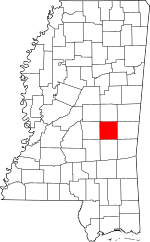
Location within the U.S. state of Mississippi
|
|
 Mississippi's location within the U.S. |
|
| Country | |
| State | |
| Founded | 1836 |
| Seat | Decatur |
| Largest city | Newton |
| Area | |
| • Total | 580 sq mi (1,500 km2) |
| • Land | 578 sq mi (1,500 km2) |
| • Water | 1.5 sq mi (4 km2) 0.3% |
| Population
(2020)
|
|
| • Total | 21,291 |
| • Density | 36.7/sq mi (14.17/km2) |
| Time zone | UTC−6 (Central) |
| • Summer (DST) | UTC−5 (CDT) |
| Congressional district | 3rd |
Newton County is a place in the state of Mississippi, USA. It's like a smaller region within the state, with its own local government. In 2020, about 21,291 people lived here. The main town, or county seat, where the county government offices are, is Decatur.
Contents
History
Newton County was created in 1836. It was named to honor Sir Isaac Newton, a famous scientist.
Newton County is next to Jasper County. Jasper County was named after Sergeant William Jasper. He was a hero in the American Revolutionary War during the Siege of Savannah in 1779. Sergeant John Newton had a very similar story.
In the early 1800s, many places were named after these two heroes. For example, four other states (Georgia, Indiana, Missouri, and Texas) also have Jasper and Newton Counties right next to each other. In some states like Illinois and Iowa, Newton is even the main town of Jasper County. In Arkansas, Jasper is the main town of Newton County. This shows that the stories of Sergeants Jasper and Newton were very well known and often linked together when these counties were named.
Geography
Newton County covers about 580 square miles. Most of this area, about 578 square miles, is land. Only a small part, about 1.5 square miles, is water.
Major Roads and Highways
 Interstate 20
 U.S. Highway 80
 Mississippi Highway 15
Neighboring Counties
- Neshoba County (to the north)
- Lauderdale County (to the east)
- Jasper County (to the south)
- Scott County (to the west)
Protected Natural Areas
- Part of the Bienville National Forest is located in Newton County.
Population Information
| Historical population | |||
|---|---|---|---|
| Census | Pop. | %± | |
| 1840 | 2,527 | — | |
| 1850 | 4,465 | 76.7% | |
| 1860 | 9,661 | 116.4% | |
| 1870 | 10,067 | 4.2% | |
| 1880 | 13,436 | 33.5% | |
| 1890 | 16,625 | 23.7% | |
| 1900 | 19,708 | 18.5% | |
| 1910 | 23,085 | 17.1% | |
| 1920 | 20,727 | −10.2% | |
| 1930 | 22,910 | 10.5% | |
| 1940 | 24,249 | 5.8% | |
| 1950 | 22,681 | −6.5% | |
| 1960 | 19,517 | −14.0% | |
| 1970 | 18,983 | −2.7% | |
| 1980 | 19,944 | 5.1% | |
| 1990 | 20,291 | 1.7% | |
| 2000 | 21,838 | 7.6% | |
| 2010 | 21,720 | −0.5% | |
| 2020 | 21,291 | −2.0% | |
| 2023 (est.) | 21,019 | −3.2% | |
| U.S. Decennial Census 1790-1960 1900-1990 1990-2000 2010-2013 |
|||
2020 Census Details
In 2020, the United States Census counted 21,291 people living in Newton County. There were 8,037 households and 5,697 families.
The population of Newton County in 2020 was made up of different groups:
| Race | Number of People | Percentage |
|---|---|---|
| White | 12,796 | 60.1% |
| Black or African American | 6,447 | 30.28% |
| Native American | 1,169 | 5.49% |
| Asian | 77 | 0.36% |
| Other/Mixed | 473 | 2.22% |
| Hispanic or Latino | 329 | 1.55% |
Communities
Newton County has several towns and communities.
City
Towns
- Chunky
- Decatur (This is the county seat)
- Hickory
- Lake (Most of this town is in Scott County)
- Union (Part of this town is in Neshoba County)
Census-Designated Place
Smaller Communities (Unincorporated)
These are places that are not officially cities or towns.
- Cedar Grove
- Duffee
- Lawrence
- Little Rock
- Stratton
Education
Students in Newton County attend schools in these districts:
- Newton County School District
- Newton Municipal School District
- Union Public School District
Conehatta Elementary School, which is part of the Choctaw Tribal School System, is located in the community of Conehatta.
See also
 In Spanish: Condado de Newton (Misisipi) para niños
 | Georgia Louise Harris Brown |
 | Julian Abele |
 | Norma Merrick Sklarek |
 | William Sidney Pittman |

