
Norfolk, Massachusetts facts for kids
Quick facts for kids
Norfolk, Massachusetts
|
||
|---|---|---|

Federated Church of Norfolk
|
||
|
||

Location in Norfolk County in Massachusetts
|
||
| Country | ||
| State | ||
| County | Norfolk | |
| Settled | 1695 | |
| Incorporated | 1870 | |
| Government | ||
| • Type | Open town meeting | |
| Area | ||
| • Total | 39.3 km2 (15.2 sq mi) | |
| • Land | 38.4 km2 (14.8 sq mi) | |
| • Water | 0.9 km2 (0.4 sq mi) | |
| Elevation | 65 m (212 ft) | |
| Population
(2020)
|
||
| • Total | 11,662 | |
| • Density | 303.7/km2 (788.0/sq mi) | |
| Time zone | UTC−5 (Eastern) | |
| • Summer (DST) | UTC−4 (Eastern) | |
| ZIP Code |
02056
|
|
| Area code(s) | 508/774 | |
| FIPS code | 25-46050 | |
| GNIS feature ID | 0618326 | |
| Website | norfolk.ma.us | |

Norfolk is a friendly town in Norfolk County, Massachusetts, in the United States. About 11,662 people lived here in 2020. It's a classic New England town.
Norfolk used to be called North Wrentham. It officially became its own town in 1870.
Contents
Discovering Norfolk's History
Norfolk is a suburban town located near Boston. It sits in the upper valley of the Charles River. The land was originally part of Dedham, which became a town in 1636.
Early Settlement and Farming
Around 1669, a few small farms were started in the area. This was an effort to settle the colonial frontier. However, the area was quite remote back then.
Wrentham separated from Dedham in 1673. What is now Norfolk was in the northern part of Wrentham. These early farms were left empty during King Philip's War in 1675–76. But people moved back to the area later in that century.
Growth and Industries
As more people settled in the late 1600s and 1700s, farming and raising cattle grew. People also started cutting timber and planting fruit trees. Small villages began to form around sawmills and gristmills. These included City Mills (around 1680) and Pondville (after 1730).

The main village center of North Wrentham developed in the late 1700s. After 1812, three cotton factories opened at Stony Brook. Later, in the 1800s, George Campbell's paper mill started making heavy wrapping and building papers.
Becoming the Town of Norfolk
The Norfolk County Railroad opened in 1849. It had a station called North Wrentham station near the village center. In 1870, North Wrentham officially separated from Wrentham. It was then named and incorporated as the town of Norfolk.
The town's population grew quickly after 1925. This was when a hospital and a state facility were built near the Walpole line. Many new homes were built before 1940 in areas like Pondville. Residential building has continued ever since. In 2014, Norfolk was a filming location for the comedy movie Ted 2.
Norfolk's Geography
Norfolk covers a total area of about 15.2 square miles (39.3 square kilometers). Most of this area, about 14.8 square miles (38.4 square kilometers), is land. The remaining 0.3 square miles (0.9 square kilometers) is water.
Norfolk's Population and People

Norfolk has seen its population grow steadily over the years.
| Historical population | ||
|---|---|---|
| Year | Pop. | ±% |
| 1870 | 1,081 | — |
| 1880 | 930 | −14.0% |
| 1890 | 913 | −1.8% |
| 1900 | 980 | +7.3% |
| 1910 | 960 | −2.0% |
| 1920 | 1,159 | +20.7% |
| 1930 | 1,429 | +23.3% |
| 1940 | 2,294 | +60.5% |
| 1950 | 2,704 | +17.9% |
| 1960 | 3,471 | +28.4% |
| 1970 | 4,656 | +34.1% |
| 1980 | 6,363 | +36.7% |
| 1990 | 9,270 | +45.7% |
| 2000 | 10,460 | +12.8% |
| 2010 | 11,227 | +7.3% |
| 2020 | 11,662 | +3.9% |
| 2022 | 11,552 | −0.9% |
In 2000, there were 10,460 people living in Norfolk. There were 2,818 households and 2,412 families. The population density was about 705 people per square mile (272 per square kilometer).
Many households (50.5%) had children under 18 living with them. Most families (78.1%) were married couples. The average household had about 3.08 people.
The population was spread out by age. About 27.2% were under 18. About 36.9% were between 25 and 44 years old. The median age in town was 37 years.
Education in Norfolk
Norfolk has several public schools for its younger residents.
- H. Olive Day Elementary School: This school serves students from Pre-Kindergarten to 2nd grade.
- Freeman-Kennedy Elementary School: This school is for students in grades 3 through 6.
- King Philip Regional Middle School: This school teaches students in grades 7 and 8.
High School Options
For high school, students attend King Philip Regional High School. This school is located in Wrentham. It is part of the King Philip Regional School District.
Students can also choose to attend specialty high schools. These include Tri-County Regional Vocational Technical High School in Franklin. Another option is Norfolk County Agricultural High School in Walpole.
Norfolk Public Library
A new public library building recently opened on town hill. Inside the new library, a special one-room schoolhouse was reopened in 2009. This building was the original public library. It now serves as a meeting room and a historical landmark.
Norfolk's Infrastructure
In 2004, the Town of Norfolk created a Department of Public Works (DPW). This department manages many important town services. It is responsible for eight main divisions:
- Water
- Wastewater
- Stormwater
- Solid Waste
- Highways
- Trees
- Vehicle Maintenance
- Grounds
All these services are managed by a Director.
Transportation in Norfolk
The Norfolk Airpark (FAA airport code 32M) used to have a 2,700-foot (820 m) runway. It was located about 2 miles (3.2 km) west of the town center. However, the airpark has been closed down.
Now, a small street with seven houses called Tailwind Circle exists where the airplane hangars used to be. The rest of the airport property is now conservation land called Leland Wild.
The Norfolk MBTA commuter rail station is in the town's center. It is located at 9 Rockwood Road. This station helps people travel to and from Boston.
Emergency Services
Norfolk has dedicated teams to keep its residents safe.
Police Department
The Norfolk Police Department is located on Sharon Avenue. It is staffed by 17 police officers, including the chief of police.
Fire Department and EMS
The town's fire department and emergency medical services (EMS) are on Main Street. Since April 2001, they have been staffed full-time, 24 hours a day, 7 days a week. Since 2004, they also provide Advanced Life Support services. The Fire Department has 13 career firefighters, including the fire chief.
Communications Center
The police and fire communications department, also called dispatch, is very important. It is operated by four full-time dispatchers and six part-time dispatchers. All these emergency services are located in the police station complex on Sharon Avenue.
In December 2015, voters approved a plan for a new public safety building. This building will be on Sharon Street. The police department will move there. The fire department will then use the space the police department leaves. This new building will also have a regional communications center. It will help with dispatch for Norfolk and three nearby towns: Wrentham, Plainville, and Franklin.
Images for kids
-
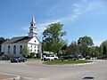
Federated Church of Norfolk
-
Seal of Norfolk, Massachusetts
-
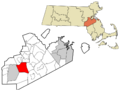
Location in Norfolk County in Massachusetts
See also
 In Spanish: Norfolk (Massachusetts) para niños
