Wrentham, Massachusetts facts for kids
Quick facts for kids
Wrentham, Massachusetts
|
|||
|---|---|---|---|
| Town of Wrentham | |||

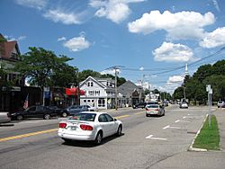
Downtown Wrentham's South Street in June 2010
|
|||
|
|||

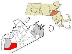
Location in Norfolk County in Massachusetts
|
|||
| Country | |||
| State | |||
| County | |||
| Settled | 1660 | ||
| Incorporated | October 17, 1673 | ||
| Government | |||
| • Type | Open town meeting | ||
| Area | |||
| • Total | 59.4 km2 (22.9 sq mi) | ||
| • Land | 57.5 km2 (22.2 sq mi) | ||
| • Water | 1.9 km2 (0.7 sq mi) | ||
| Elevation | 77 m (253 ft) | ||
| Population
(2020)
|
|||
| • Total | 12,178 | ||
| • Density | 211.8/km2 (548.6/sq mi) | ||
| Time zone | UTC−5 (Eastern) | ||
| • Summer (DST) | UTC−4 (Eastern) | ||
| ZIP Codes |
02093
02070 (Sheldonville) |
||
| Area code(s) | 508/774 | ||
| FIPS code | 25-82315 | ||
| GNIS feature ID | 0618334 | ||
| Website | wrentham.ma.us | ||
Wrentham (/ˈrɛnθəm/ REN-thəm) is a town located in Norfolk County, Massachusetts, United States. In 2020, about 12,178 people lived there.
Contents
Discovering Wrentham's Past
In 1660, five men from Dedham went to explore the area near a Native American leader's home. They reported back to the town leaders about what they found. Everyone was very excited about their report.
Starting a New Settlement
In March 1661, the town decided to start a new settlement in the explored area. Two men, Richard Ellis and Timothy Dwight, were chosen to talk with King Philip. Their goal was to buy the land known as Wollomonopoag.
They bought 600 acres of land for about £24. A person named Captain Willett paid for the land. The town planned to repay him with a tax, but there was a disagreement about who should pay. This meant Willett was not paid back for a few years.
Setting Up the New Community
After the new community's borders were set, Dedham gave up its rights to the land. In return, the new settlers agreed to pay Dedham £160 over four years, starting in 1661. However, by 1663, not much progress had been made.
A meeting was held, and ten men volunteered to move there. They had concerns about how to proceed. It was decided that land lots would be given out by lottery. Those who had already started improving their land could keep it. Land for a church, burial ground, and roads was also set aside.
Challenges and Growth
Not much happened in Wollomonopoag until 1668. At that time, reports came that Native Americans were planting corn and cutting trees on the land Dedham had bought. A letter was sent to warn them to leave. They replied that they intended to stay.
The town then asked Captain Willett to speak with King Philip. In 1669, King Philip offered to negotiate for more land if they sent him a "holland shirt." An agreement was reached to clear the land title for about £17. It's not known if a shirt was traded.
In 1671, a new effort to settle began. Five men moved to Wollomonopoag, and then Rev. Samuel Man, a former teacher, joined them. A corn mill was also built. The new settlers were mostly middle-class people from outside Dedham or second-generation Dedhamites.
Becoming an Independent Town
The settlers in Wollomonopoag felt they were too dependent on Dedham. They complained about landowners who didn't live there but whose land value increased because of the settlers' hard work. They also felt left out because the town government was so far away.
With Dedham's approval, the new town of Wrentham officially separated on October 16, 1673.
Key Historical Moments
Wrentham was burned down during King Philip's War (1675–1676). Later, in the 1800s, it was home to Day's Academy, a school. The famous educational reformer Horace Mann lived in Wrentham for a short time. Helen Keller, a well-known author and activist, also lived here.
Over time, parts of Wrentham became separate towns. North Wrentham became its own town in 1870. Plainville also split off in 1905.
Exploring Wrentham's Landscape
Wrentham covers about 22.9 square miles (59 km2) in total. About 22.2 square miles (57 km2) of this is land, and 0.7 square miles (1.8 km2) is water.
Neighboring Towns and Waterways
Wrentham shares borders with several towns. To the north is Norfolk, to the east is Foxboro. To the south are Plainville and Cumberland, Rhode Island. To the southwest is Bellingham, and to the west is Franklin.
The town has two large lakes in its center: Lake Pearl and Lake Archer. Mirror Lake is on the border with Norfolk. Wrentham's water flows into four different river systems: the Charles River, the Taunton River, the Blackstone River, and the Ten Mile River.
Sheldonville and Unique Identity
Sheldonville, also known as West Wrentham, is a rural part of town. It keeps its unique identity as an old farming area. Sheldonville has active commercial orchards and its own ZIP Code (02070).
The Name Wrentham
Wrentham, Massachusetts, is the only town with this name in the United States. It is named after a village called Wrentham in Suffolk, England. The only other place named Wrentham is in Alberta, Canada. Wrentham, Massachusetts, is the largest of the three.
Understanding Wrentham's People
| Historical population | ||
|---|---|---|
| Year | Pop. | ±% |
| 1850 | 3,037 | — |
| 1860 | 3,406 | +12.2% |
| 1870 | 2,292 | −32.7% |
| 1880 | 2,481 | +8.2% |
| 1890 | 2,566 | +3.4% |
| 1900 | 2,720 | +6.0% |
| 1910 | 1,743 | −35.9% |
| 1920 | 2,808 | +61.1% |
| 1930 | 3,584 | +27.6% |
| 1940 | 4,674 | +30.4% |
| 1950 | 5,341 | +14.3% |
| 1960 | 6,685 | +25.2% |
| 1970 | 7,315 | +9.4% |
| 1980 | 7,580 | +3.6% |
| 1990 | 9,006 | +18.8% |
| 2000 | 10,554 | +17.2% |
| 2010 | 10,955 | +3.8% |
| 2020 | 12,178 | +11.2% |
| 2023* | 12,543 | +3.0% |
| * = population estimate. Source: United States Census records and Population Estimates Program data. |
||
In 2000, there were 10,554 people living in Wrentham. There were 3,402 households and 2,653 families. The population density was about 475.5 inhabitants per square mile (183.6/km2).
Population Breakdown
About 43% of households had children under 18 living with them. Most households (68.3%) were married couples. About 17% of households were individuals living alone.
The average household had 2.89 people, and the average family had 3.31 people. The population was spread out by age. About 27.8% were under 18, and 11.6% were 65 or older. The average age was 39 years old.
Learning in Wrentham
Wrentham has a good education system for its students.
Elementary Schools
The Wrentham Elementary School campus has three buildings for different grade levels. The Delaney Elementary School is for the youngest students. The Vogel Elementary School is for a mix of lower grades and arts classes. The Roderick Elementary School is for the older elementary students, up to grade 6. All three buildings are located together in the center of Wrentham.
Middle and High Schools
For middle and high school, Wrentham is part of the King Philip Regional School District. Students attend King Philip Regional Middle School in Norfolk. King Philip Regional High School, located in Wrentham, serves students from Wrentham, Norfolk, and Plainville.
Other school options are also available. These include Tri-County Regional Vocational Technical High School in Franklin and Norfolk County Agricultural High School in Walpole. There is also a private Catholic school, Bishop Feehan High School, in Attleboro.
Getting Around Wrentham
Wrentham is part of the Greater Attleboro Taunton Regional Transit Authority. This helps with public transportation in the area.
Famous People from Wrentham
Many interesting people have connections to Wrentham:
- Dale Arnold, a radio host
- Ayla Brown, a singer and basketball player
- Scott Brown, a former U.S. Ambassador and U.S. Senator
- John Cena, a professional wrestler and actor
- Cesar Chelor, an early African-American plane maker
- Chris Doughty, a businessman and politician
- Charlotte W. Hawes, a composer
- Gail Huff, a former news reporter
- Helen Keller, a famous suffragist and author
- Jake Layman, an NBA basketball player
- Garth Snow, a former NHL goaltender and general manager
- Scott Zolak, a former NFL quarterback and current sports commentator
See also
 In Spanish: Wrentham (Massachusetts) para niños
 | Roy Wilkins |
 | John Lewis |
 | Linda Carol Brown |


