Northampton, Pennsylvania facts for kids
Quick facts for kids
Northampton
|
||
|---|---|---|

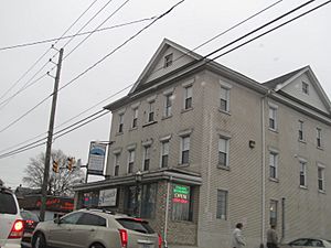
Northampton in December 2012
|
||
|
||

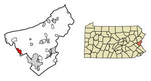
Location of Northampton in Northampton County, Pennsylvania (left) and of Northampton County in Pennsylvania (right)
|
||
| Country | ||
| State | ||
| County | Northampton | |
| Area | ||
| • Borough | 2.64 sq mi (6.83 km2) | |
| • Land | 2.47 sq mi (6.40 km2) | |
| • Water | 0.17 sq mi (0.43 km2) | |
| Elevation | 328 ft (100 m) | |
| Population
(2020)
|
||
| • Borough | 10,395 | |
| • Density | 4,206.80/sq mi (1,624.56/km2) | |
| • Metro | 865,310 (US: 68th) | |
| Time zone | UTC-5 (EST) | |
| • Summer (DST) | UTC-4 (EDT) | |
| ZIP Code |
18067
|
|
| Area codes | 610 and 484 | |
| FIPS code | 42-54696 | |
| Primary airport | Lehigh Valley International Airport | |
| Major hospital | Lehigh Valley Hospital–Cedar Crest | |
| School district | Northampton Area | |
Northampton is a small town, also called a borough, in Northampton County, Pennsylvania, United States. In 2020, about 10,395 people lived there. Northampton is located about 7.8 miles (12.6 km) north of Allentown. It is also part of the larger Lehigh Valley area. This area is home to over 860,000 people.
Contents
History of Northampton
Northampton was formed in 1902. It was created by joining three smaller villages: Siegfried, Newport, and Stemton.
The Cement Industry and Atlas Company
The area around Northampton has a lot of limestone. This rock is very important for making cement. Because of this, Northampton became a major center for cement production.
The Atlas Portland Cement Company was a huge company based here. From 1895 to 1982, it was the biggest cement company in the world. Atlas Cement made about eight million barrels of cement for the Panama Canal. This was most of the cement used to build the canal!
Atlas Cement was bought by another company in 1980. It stopped working in Northampton in 1982. The last tall smokestack from the plant was taken down in 1993. Today, machines do most of the work. This means fewer people are needed in cement factories.
Many people in Northampton worked at Atlas Cement. Their families still feel a strong connection to the company. For example, the Northampton Area School District's sports mascot is the "Konkrete Kid." This name comes from the town's cement history.
Atlas Memorial Cement Museum
In 1997, the Atlas Memorial Cement Museum opened in Northampton. Edward Pany started the museum. His father, who came from Austria, worked at Atlas his whole life. Many immigrant workers from countries like Poland and Ukraine also worked there. The museum helps everyone remember how important the cement industry was to the area.
Community Events
Northampton used to host the Northampton County Fair. This big event happened every year in the 1940s and 1950s. It had many food stands, fun rides, animals, and shows. Even the famous Ringling Brothers and Barnum and Bailey performed there. People from all over the East Coast came to the two-week fair. Buses ran often from downtown Northampton to the fairgrounds.
The town also had the Northampton Jack Frost Parade every October. This parade celebrated the start of winter. It featured marching bands and colorful floats.
Geography and Climate
Northampton is about 8 miles (13 km) north of Allentown. It is also about 15 miles (24 km) west of Easton. The town sits at an elevation of about 370 feet (113 meters) above sea level.
The Lehigh River forms the western edge of Northampton. This river separates Northampton County from Lehigh County.
Northampton has a climate with hot summers. The average temperature in January is about 28.8°F (-1.8°C). In July, it's around 73.7°F (23.2°C).
Population Changes
| Historical population | |||
|---|---|---|---|
| Census | Pop. | %± | |
| 1800 | 573 | — | |
| 1810 | 710 | 23.9% | |
| 1830 | 1,544 | — | |
| 1910 | 8,729 | — | |
| 1920 | 9,349 | 7.1% | |
| 1930 | 9,839 | 5.2% | |
| 1940 | 9,622 | −2.2% | |
| 1950 | 9,332 | −3.0% | |
| 1960 | 8,866 | −5.0% | |
| 1970 | 8,389 | −5.4% | |
| 1980 | 8,240 | −1.8% | |
| 1990 | 8,717 | 5.8% | |
| 2000 | 9,405 | 7.9% | |
| 2010 | 9,926 | 5.5% | |
| 2020 | 10,395 | 4.7% | |
| Sources: | |||
In 2000, there were 9,405 people living in Northampton. There were 3,869 households and 2,634 families. About 30% of households had children under 18. The average household had 2.4 people. The median age in the borough was 39 years old.
Transportation in Northampton
Northampton has about 35.90 miles (57.78 km) of public roads. Most of these roads are cared for by the borough itself. A smaller part is maintained by the Pennsylvania Department of Transportation (PennDOT).
Pennsylvania Route 329 is the main highway that goes through Northampton. It follows 21st Street, running from the southwest to the northeast.
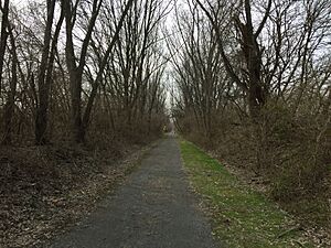
There are also trails for walking and biking. The Nor-Bath Trail is a path built on an old railroad line. It starts in downtown Northampton. The Delaware and Lehigh (D&L) Trail also passes through the town.
Education in Northampton
The Northampton Area School District serves the borough. Students in grades 9 through 12 go to Northampton Area High School. This high school is located right in the borough. There are also four elementary schools and one middle school in the district.
Northampton is also home to Good Shepherd Catholic School. This school serves students from pre-kindergarten up to 8th grade. It is part of the Diocese of Allentown.
Museums
- Atlas Cement Memorial Museum, located in Northampton
Notable People
- Dorothy Page, a former actress
Sister City
 Stegersbach, Austria
See also
 In Spanish: Northampton (Pensilvania) para niños
 | Dorothy Vaughan |
 | Charles Henry Turner |
 | Hildrus Poindexter |
 | Henry Cecil McBay |


