Northern boundary of Massachusetts facts for kids
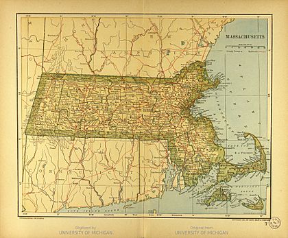
The northern boundary of Massachusetts is the line that separates it from two other states: Vermont and New Hampshire. Most of this border is a fairly straight line. It starts in the northwest corner of Massachusetts and goes east towards Dracut, near Lowell. From there, the border follows a series of short, straight lines. These lines stay about 3 miles (4.8 km) north of the Merrimack River as it curves. The border finally ends where Massachusetts meets the Atlantic Ocean.
Contents
How the Border Was Created
Early Colonial Charters and Claims
The story of Massachusetts' northern border began a long time ago. In 1629, the Massachusetts Bay Colony received a special document called a charter. This charter gave the colony land between the Merrimack River and the Charles River.
The charter said the northern border should be 3 miles (4.8 km) north of the northernmost bend of the Merrimack River. The southern border was to be 3 miles (4.8 km) south of the southernmost bend of the Charles River. At that time, people hadn't fully explored these rivers. So, the exact borders of the colony were not clear.
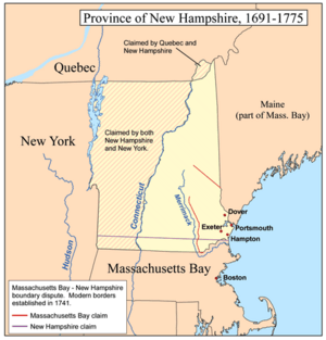
It turned out the Merrimack River started much farther north than expected. This meant the 1629 charter actually gave Massachusetts Bay most of what is now New Hampshire. It took many years for everyone to understand these land claims.
In 1691, a new charter was given to the Province of Massachusetts Bay. This charter combined the Massachusetts Bay Colony with the Plymouth Colony and other areas like present-day Maine. The northern border of the main part of Massachusetts stayed the same as defined in 1629.
Disputes and Decisions with New Hampshire
The Province of New Hampshire and the Province of Massachusetts Bay often disagreed about their shared borders. They especially argued over the meaning of "three miles northward of the Merrimack River." New Hampshire thought the line should start 3 miles (4.8 km) north of the river's mouth (where it meets the ocean). Massachusetts, however, claimed the line should be 3 miles (4.8 km) north of the river's northernmost point. This would have given Massachusetts much more land, reaching far north of what is now Concord, New Hampshire.
To settle this big argument, New Hampshire asked King George II for help. In 1740, King George II made a decision. He declared that the boundary should follow a curved line. This line would stay 3 miles (4.8 km) from the Merrimack River. It would run from the ocean to a point 3 miles (4.8 km) north of Pawtucket Falls in Lowell. From that point, a straight line would be drawn due west. This line would meet the western boundary of Massachusetts.
This decision gave New Hampshire even more land than it had asked for. This is because Pawtucket Falls is south of the Merrimack River's mouth. This ruling by King George II officially set the northern boundary of Massachusetts as we know it today.
Marking the Border
The Old Boundary Pine
The place where the curved line and the straight westward line met was very important. It was marked by a special pine tree called the "Old Boundary Pine." A surveyor named George Mitchell marked this tree on March 21, 1741. This showed exactly where the two parts of the border connected.
The original pine tree is no longer there. But the spot is now marked by a large granite monument. This monument is known as the Boundary Pine Monument. The current monument was placed in 1890.
Border Markers Today
Along the rest of the border, there are about 50 large granite markers. These markers help people know exactly where the boundary is. There are also other types of markers. For example, a copper bolt set in granite marks the point where Vermont, Massachusetts, and New Hampshire all meet.
The "curved" parts of the border that follow the Merrimack River are not truly curved. Instead, they are made up of many short, straight line segments. These segments are placed to closely follow the river's curve at a distance of 3 miles (4.8 km) north of it.
Another granite marker was placed in 1890 on the beach. This marker is between Salisbury, Massachusetts and Seabrook, New Hampshire. It stands 80 feet (24 meters) from the high tide line. This marks the end of the surveyed land border. From there, the border extends into the Atlantic Ocean.
Vermont's Independence and Borders
New Hampshire also claimed all the land to the west, almost to what is now the western border of Vermont. At the same time, New York claimed land east to the Connecticut River, which is Vermont's current eastern border. This meant both New Hampshire and New York claimed all of Vermont.
King George III made a ruling that the border should be the low-water line on the west bank of the Connecticut River. However, the people living in the area between the Connecticut River and Lake Champlain declared their independence in 1777. They formed the Vermont Republic.
New Hampshire finally gave up its claim to Vermont in 1782. New York also gave up its claim in 1790. This happened when Vermont was about to join the United States. Vermont officially became a state in 1791.
 | Aurelia Browder |
 | Nannie Helen Burroughs |
 | Michelle Alexander |


