
Oakley, California facts for kids
Quick facts for kids
City of Oakley
|
|||
|---|---|---|---|

Oakley City Hall
|
|||
|
|||

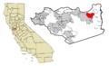
Location in Contra Costa County and the state of California
|
|||

Oakley, California
Location in the United States
|
|||
| Country | |||
| State | |||
| County | Contra Costa | ||
| Incorporated | July 1, 1999 | ||
| Area | |||
| • Total | 16.17 sq mi (41.88 km2) | ||
| • Land | 15.86 sq mi (41.09 km2) | ||
| • Water | 0.30 sq mi (0.79 km2) 1.87% | ||
| Elevation | 20 ft (6 m) | ||
| Population
(2020)
|
|||
| • Total | 43,357 | ||
| • Density | 2,681.3/sq mi (1,035.27/km2) | ||
| Time zone | UTC-8 (PST) | ||
| • Summer (DST) | UTC-7 (PDT) | ||
| ZIP code |
94561
|
||
| Area code(s) | 925 | ||
| FIPS code | 06-53070 | ||
| GNIS feature IDs | 277567, 2411294 | ||
| Website | ci.oakley.ca.us | ||

Oakley is a city in Contra Costa County, California, United States. It is part of the larger San Francisco Bay Area. In 2020, about 43,357 people lived there. Oakley became an official city in 1999. This makes it the newest city in Contra Costa County.
Contents
- What's in a Name? The Story of Oakley
- A Look Back: Oakley's History
- Where is Oakley? Geography and Environment
- Growing Grapes: Oakley's Agriculture
- Getting Around: Transportation in Oakley
- Who Lives in Oakley? Demographics
- Learning in Oakley: Education
- Famous Faces from Oakley
- Images for kids
- See also
What's in a Name? The Story of Oakley
The name "Oakley" comes from two old English words. "Oak" refers to the many oak trees in the area. "-Ley" means "field" or "meadow." So, Oakley means "meadow of oak trees." This name still fits the area today.
The city almost had a different name! One of the city's founders, Randolph Marsh, wanted to name it "Dewey." He wanted to honor Admiral Dewey for his success in a battle during the Spanish-American War. But his friend, J.T. Whightman, liked "Oakley" better. They played a game of cribbage to decide. Marsh lost the game, so the name "Oakley" won. Even though he lost, Marsh made sure his name would be remembered. He chose street names in downtown Oakley whose first letters spelled "Marsh": Main, Acme, Ruby, Star, and Home.
A Look Back: Oakley's History
.jpg)
Ancient Times: Early People in Oakley
Scientists have found signs of people living in the Oakley area long ago. One large shell mound was found in the early 1900s. It was near what is now the eastern part of town. These sites show that people lived here around 1000 A.D. The land was rich in resources for them.
The first known group of people in this area were the Bay Miwok people. They lived here between 1100 and 1770 AD. These groups, sometimes called Julpunes or Pulpunes by early European explorers, lived in small communities. They had permanent villages and seasonal camps across their land.
European Arrivals: Spanish and American Periods
Spanish explorers first came to the Oakley area in the 1770s. The De Anza expedition explored the region in 1775–76. However, they did not set up colonies. Later, in the 1800s, Europeans settled in the Delta. Many of them died from diseases like malaria and smallpox.
Oakley got its first post office in 1898. The city officially became an incorporated city in 1999. This means it gained its own local government.
Where is Oakley? Geography and Environment
Oakley gets about 21 inches of rain each year. In July, the average high temperature is around 96°F (36°C). In January, the average low is about 40°F (4°C). The sun shines brightly for about 52% of the year.
Oakley's western edge is next to California State Route 160. The city of Antioch is to the west. Brentwood is to the south. Bethel Island is to the east. The Sacramento-San Joaquin Delta forms the northern border. To the southwest, you can see the impressive Mt. Diablo.
Growing Grapes: Oakley's Agriculture
Oakley has been home to vineyards since the late 1800s. Early immigrants from Portugal and Italy found the climate perfect for growing grapes. They planted thousands of acres of vineyards.
Today, nearly 80% of Oakley's vineyards grow Zinfandel grapes. Oakley harvests about 2,000 tons of grapes each year. These grapes are used by many local wineries.
Getting Around: Transportation in Oakley
The BNSF Railway runs through Oakley from east to west. This railway also carries Amtrak California's San Joaquin passenger train service. In March 2023, it was decided that the Amtrak station in Antioch–Pittsburg would close. A new Oakley Station will replace it.
California State Route 4 used to go right through downtown Oakley. But from 2000 to 2008, a bypass was built. This new road helps traffic move more smoothly around the city. Oakley is also part of a plan for bicycle paths. There are already paths in Oakley, and more are planned for the future.
Who Lives in Oakley? Demographics
| Historical population | |||
|---|---|---|---|
| Census | Pop. | %± | |
| 1970 | 1,306 | — | |
| 1980 | 2,816 | 115.6% | |
| 1990 | 18,374 | 552.5% | |
| 2000 | 25,619 | 39.4% | |
| 2010 | 35,432 | 38.3% | |
| 2020 | 43,357 | 22.4% | |
| U.S. Decennial Census | |||
In 2010, Oakley had a population of 35,432 people. Most people lived in homes, with only a small number in group living situations. About 35% of the population was of Hispanic or Latino background.
Many households in Oakley had children under 18 living in them. The average household had about 3.29 people. The average family had about 3.62 people. The median age in Oakley was 32 years old. This means half the people were younger than 32, and half were older.
Most homes in Oakley were owned by the people living in them (76.1%). About 23.9% of homes were rented.
Learning in Oakley: Education
Oakley's schools are mainly served by two districts: the Oakley Union Elementary School District (for grades K–8) and the Liberty Union High School District.
Elementary Schools
- Oakley Elementary School
- Gehringer Elementary School
- Laurel Elementary School
- Vintage Parkway Elementary School
- Iron House Elementary School
- Orchard Park School (K–8, part of the Antioch Unified School District)
- Almond Grove Elementary School
- Summer Lake Elementary School (opened 2019)
Middle Schools
- O'Hara Park Middle School
- Delta Vista Middle School
- Orchard Park School (K–8, part of the Antioch Unified School District)
High Schools
- Freedom High School
Public Libraries
The Oakley branch of the Contra Costa County Library system is located in Oakley.
Famous Faces from Oakley
- Joe Mixon – A professional football player for the Houston Texans. He used to play for the Cincinnati Bengals.
- Nguyen Do – A poet, editor, and translator who moved to Oakley from San Francisco.
- Lisa Joann Thompson – A dancer, actress, and choreographer. She lived in Oakley during her high school years.
- Malik Izaak Taylor (also known as Phife Dawg) – A famous rapper and member of the group A Tribe Called Quest. He moved to Oakley from New York.
Images for kids
-
Location of Oakley in Contra Costa County
See also
 In Spanish: Oakley (California) para niños
