
Bethel Island facts for kids

USGS aerial imagery of Bethel Island (right) and Jersey Island (left).
|
|

Bethel Island
Location in Sacramento-San Joaquin River Delta

Bethel Island
Location in San Francisco Bay Area

Bethel Island
Location in California

Bethel Island
Location in the United States
|
|
| Geography | |
|---|---|
| Location | Northern California |
| Coordinates | 38°01′53″N 121°38′27″W / 38.03131°N 121.640787°W |
| Adjacent bodies of water | San Joaquin River |
| Area | 3,500 acres (1,400 ha) |
| Administration | |
| State | |
| County | Contra Costa |
| Demographics | |
| Population | approx. 3700 |
|
Bethel Island
|
|
|---|---|
| Country | |
| State | |
| County | Contra Costa |
| Government | |
| • Type | Special act district |
| Area | |
| • Total | 5.82 sq mi (15.07 km2) |
| • Land | 5.25 sq mi (13.60 km2) |
| • Water | 0.57 sq mi (1.47 km2) 0% |
| Elevation | -7 to -15 ft (-2 m) |
| Population
(2020)
|
|
| • Total | 2,131 |
| • Density | 405.83/sq mi (156.69/km2) |
| Time zone | UTC-8 (PST) |
| • Summer (DST) | UTC-7 (PDT) |
| ZIP code |
94511
|
| Area code(s) | 925 |
| FIPS code | 06-06210 |
| GNIS feature IDs | 1658045, 2407834 |

Bethel Island is an island located in the Sacramento–San Joaquin River Delta in Contra Costa County, California. It's about 10 kilometers (6 miles) east of Antioch. People often call it "the heart of the California Delta" because it's a popular spot for fun activities.
Bethel Island is also a special community called a census-designated place (CDP). This means it's a place with a name and a population count, but it's not officially a city. In 2020, about 2,131 people lived here. The community is managed by a special group called the Bethel Island Municipal Improvement District (BIMID). It's a favorite place for people who enjoy hunting, fishing, and boating.
Contents
History of Bethel Island
Bethel Island got its name from the Bethell Brothers, Frank and Warren Bethell. They started the first successful farm on the island, which they called Sand Mound Ranch.
How the Island Was Formed
The land that is now Bethel Island was created between 1859 and 1870. Many people worked to claim and develop this land. Before it became an island, it was known as "Sandmound Ranch" or "Bethel Tract." It didn't become a true island until 1911. That's when a waterway called Dutch Slough was dug further east to connect with Sandmound Slough, making it completely surrounded by water.
The Post Office and the Name
The first post office on the island opened in 1898. It was named after its first postmaster, Franklin Cloud Bethell. There's a cool story about the name: a postal worker thought "Bet Hell" sounded bad. So, they changed it to "Bethel," which means "House of God" in Hebrew. Even though the post office closed in 1902, the name "Bethel" stuck. A new post office opened on Bethel Island in 1947.

Early Days and Development
Warren King Bethell, born in 1823, was a key figure. He bought the 3,500-acre Sand Mound Ranch in 1872 with partners. He encouraged his younger brother, Franklin, to join him. Franklin later became the first postmaster.
In 1901, the Bethell family sold their land on the island. Many of the early landowners were "land speculators." This means they bought land hoping its value would go up.
Life on the Island in the 20th Century
A wooden bridge was built in 1911 to connect the island to the mainland. After some issues, it was replaced in 1921. In the late 1930s, a place called Farrar Park opened. It was a resort with picnic areas and swimming. This was the first fun spot for visitors on the island.

More businesses for recreation started to appear. Remsburg Marina opened in 1938, and a popular fishing resort called Frank's began in 1944. Electricity came to the island in 1946, and telephone service arrived in 1949. These made Bethel Island even more popular for recreation. By the 1950s, it was a favorite spot for sport fishermen.
Bethel Island Today
In 2019, a new housing project called Delta Coves began construction. It includes 494 homes built around a man-made lagoon. Today, Bethel Island is the most populated island in the delta area. It's still known as "The Heart of the Delta."
Geography of Bethel Island
Bethel Island covers about 13.60 square kilometers (5.25 square miles) of land. It's located about 9 miles (14.5 km) east of Antioch. The island is surrounded by several waterways like Taylor, Piper, Dutch, and Sandmound Sloughs. To protect the island from water, there are 11.5 miles (18.5 km) of earthen walls called levees.
The only way to get to Bethel Island by land is a bridge. This bridge connects Bethel Island Road to Cypress Road in Oakley. Other towns nearby include Oakley, Knightsen, and Brentwood.
Climate
Bethel Island has a warm-summer Mediterranean climate. This means it has hot, dry summers and mild, wet winters.
Population and People
| Historical population | |||
|---|---|---|---|
| Census | Pop. | %± | |
| 2000 | 2,312 | — | |
| 2010 | 2,137 | −7.6% | |
| 2020 | 2,131 | −0.3% | |
| U.S. Decennial Census | |||
In 2020, the population of Bethel Island was 2,131 people. Most people live in households. The average age of residents in 2010 was about 52.8 years old. Many people who live here own their homes.
How Bethel Island is Governed
Bethel Island is managed by a special group called the Bethel Island Municipal Improvement District (BIMID). This group was created in 1960 by the California State legislature. BIMID acts like a local government for the island.
BIMID is mainly in charge of:
- Keeping the levees around the island strong and in good repair.
- Managing the drainage system.
- Taking care of the local park.
The island also gets help from other services:
- The Contra Costa Fire Protection District (CCFPD) handles fire emergencies.
- The Contra Costa County Sheriff's Department provides police services.
BIMID owns about 100 acres (40 hectares) of land in the middle of the island. This land is used to get sand for levee maintenance and to plant new trees.
What's on the Island
Bethel Island is mostly below sea level, but it's protected by its long levee system. About 3,700 people live on the island. There are around 1,300 houses, four mobile home parks, 13 marinas for boats, a business area, and some farmland.
Fun Things to Do
Bethel Island is a great place for outdoor activities.
- Golf: The Bethel Island Golf Course is a popular spot for golfers.
- Water Sports: The island is famous for boating, fishing, and hunting. Many people come here to enjoy the water and nature.
Images for kids
-
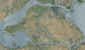
USGS aerial imagery of Bethel Island (right) and Jersey Island (left).
-
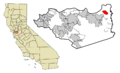
Contra Costa County, California Incorporated and Unincorporated areas with Bethel Island Highlighted.
-
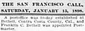
Newspaper clipping from San Francisco Call January 15, 1898
-
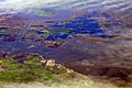
California Delta at flood stage, 2009. Bethel Island is at bottom left of image.
