Ocean Shores, Washington facts for kids
Quick facts for kids
Ocean Shores, Washington
|
|
|---|---|

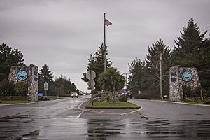
Ocean Shores main entrance
|
|

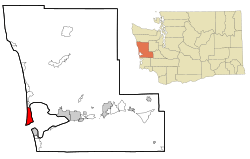
Location of Ocean Shores, Washington
|
|
| Country | United States |
| State | Washington |
| County | Grays Harbor |
| Founded | 1970 |
| Incorporated | November 3, 1970 |
| Government | |
| • Type | Council–manager |
| Area | |
| • Total | 13.78 sq mi (35.68 km2) |
| • Land | 8.52 sq mi (22.05 km2) |
| • Water | 5.26 sq mi (13.63 km2) |
| Elevation | 13 ft (4 m) |
| Population
(2020)
|
|
| • Total | 6,715 |
| • Estimate
(2023)
|
7,549 |
| • Density | 887.0/sq mi (342.3/km2) |
| Time zone | UTC–8 (Pacific (PST)) |
| • Summer (DST) | UTC–7 (PDT) |
| ZIP Code |
98569
|
| Area code(s) | 360 and 564 |
| FIPS code | 53-50570 |
| GNIS feature ID | 1510681 |
Ocean Shores is a city located in Grays Harbor County, Washington, in the United States. It sits on the Point Brown peninsula right on the Pacific coast. In 2020, about 6,715 people lived there. By 2023, the population was estimated to be around 7,549 people.
Contents
History of Ocean Shores

Early Days and Native Tribes
Long before European settlers arrived, the Point Brown peninsula was an important place for local Native American tribes. The Chinook, Chehalis, and Quinault tribes, along with others, used this area for trading and other activities.
European Exploration and Settlement
In 1792, Captain Robert Gray sailed into the bay and called it Bullfinch Harbor. Later, Captain George Vancouver renamed it Grays Harbor in honor of Captain Gray. The first European settler on the peninsula was Matthew McGee in the early 1860s. He sold part of the land to A.O. Damon in 1878, who set up a trading center.
Eventually, the land was passed to Ralph Minard, who ran a cattle ranch there until 1960. He then sold the land to the Ocean Shores Development Corporation.
Building a New City
The Ocean Shores Development Corporation bought the land in 1960. They planned to build a big new city. They started selling land lots from a travel trailer on the dunes. People quickly became interested in this "California-style" development.
Lots started at $595 and were sold even before roads were fully built. As more lots sold, prices went up. The first roads were about 20 miles (32 km) long. The downtown area even had bright mercury vapor lights, showing it was a busy place. In the first year, 25 homes were built. Their owners became founding members of the Ocean Shores Community Club.
Growth and Famous Visitors
As Ocean Shores grew, the Ginny Simms Restaurant and Nightclub became popular. It attracted many Hollywood stars. On its opening night, celebrities flew in on chartered planes, and 11,000 people came to see them at Bowerman Basin.
By December 1960, plans included 25 miles (40 km) of canals and a six-hole golf course. A shopping mall, 100 motel units, three restaurants, and an airstrip were quickly built. The marina opened in 1963.
The SS Catala ship was brought from California to be a "boatel" (a hotel on a boat) and an office for charter boats. However, a storm later pushed it onto the sand, and for many years it was a famous shipwreck on the Washington Coast. In 1966, the city's entrance gates were put in place.
Pat Boone and Incorporation
In 1967, singer Pat Boone became involved with Ocean Shores Estates Incorporated. He helped promote the development by hosting celebrity golf tournaments.
By 1969, Ocean Shores was known as a very wealthy small city for its size, with many permanent residents. The city officially became a city in 1970. A planning group was then formed to organize the city's zones and streets. The first school opened in 1971, and road paving began in earnest.
During the 1970s, the town faced some challenges due to a statewide economic slowdown. But by the 1980s, things improved, and more homes and businesses were built.
Geography and Climate
Location and Size
Ocean Shores covers a total area of about 13.78 square miles (35.68 sq km). Of this, about 8.52 square miles (22.05 sq km) is land, and 5.26 square miles (13.63 sq km) is water.
Weather Patterns
Ocean Shores has an oceanic climate, which means it has cool, wet winters and mild, drier summers. This is similar to a mediterranean climate.
The weather here is like nearby Aberdeen, but Ocean Shores usually has a smaller range of temperatures. It doesn't get as extremely hot in the summer because of its coastal location.
| Climate data for Ocean Shores, Washington | |||||||||||||
|---|---|---|---|---|---|---|---|---|---|---|---|---|---|
| Month | Jan | Feb | Mar | Apr | May | Jun | Jul | Aug | Sep | Oct | Nov | Dec | Year |
| Record high °F (°C) | 68 (20) |
76 (24) |
76 (24) |
85 (29) |
93 (34) |
94 (34) |
96 (36) |
94 (34) |
92 (33) |
85 (29) |
69 (21) |
64 (18) |
96 (36) |
| Mean daily maximum °F (°C) | 49 (9) |
51 (11) |
54 (12) |
56 (13) |
60 (16) |
63 (17) |
66 (19) |
67 (19) |
67 (19) |
60 (16) |
53 (12) |
48 (9) |
58 (14) |
| Mean daily minimum °F (°C) | 38 (3) |
37 (3) |
39 (4) |
41 (5) |
46 (8) |
49 (9) |
52 (11) |
52 (11) |
49 (9) |
44 (7) |
40 (4) |
36 (2) |
44 (6) |
| Record low °F (°C) | 11 (−12) |
9 (−13) |
22 (−6) |
26 (−3) |
27 (−3) |
33 (1) |
32 (0) |
35 (2) |
30 (−1) |
24 (−4) |
12 (−11) |
7 (−14) |
7 (−14) |
| Average precipitation inches (mm) | 11.10 (282) |
8.18 (208) |
8.08 (205) |
5.73 (146) |
3.60 (91) |
2.57 (65) |
1.36 (35) |
1.64 (42) |
2.57 (65) |
7.56 (192) |
12.09 (307) |
10.79 (274) |
75.27 (1,912) |
Population of Ocean Shores
| Historical population | |||
|---|---|---|---|
| Census | Pop. | %± | |
| 1970 | 800 | — | |
| 1980 | 1,692 | 111.5% | |
| 1990 | 2,301 | 36.0% | |
| 2000 | 3,836 | 66.7% | |
| 2010 | 5,569 | 45.2% | |
| 2020 | 6,715 | 20.6% | |
| 2023 (est.) | 7,549 | 35.6% | |
| U.S. Decennial Census 2020 Census |
|||
Population in 2020
| Race | Number | Percent |
|---|---|---|
| White (NH) | 5,713 | 85.1% |
| Black or African American (NH) | 66 | 1.0% |
| Native American (NH) | 141 | 2.1% |
| Asian (NH) | 127 | 1.9% |
| Pacific Islander (NH) | 9 | 0.1% |
| Some Other Race (NH) | 45 | 0.7% |
| Mixed/Multi-Racial (NH) | 337 | 5.0% |
| Hispanic or Latino | 277 | 4.1% |
| Total | 6,715 | 100.0% |
In 2020, there were 6,715 people living in Ocean Shores. There were 3,437 households and 2,062 families. The city had about 788 people per square mile (304 per sq km). There were 5,518 housing units.
Most of the people (86.3%) were White. Other groups included 1.0% African American, 2.3% Native American, and 1.9% Asian. About 4.1% of the population was Hispanic or Latino. About 5.6% of residents were under 18 years old, and 41.0% were 65 or older.
Population in 2010
In 2010, Ocean Shores had 5,569 people living in 2,707 households. The population density was about 655 people per square mile (253 per sq km). There were 4,758 housing units.
The racial makeup was mostly White (90.2%). About 12.6% of residents were under 18 years old. The average age was 57.3 years. The population was 48.3% male and 51.7% female.
Schools in Ocean Shores
Ocean Shores is part of the North Beach School District. This district operates a high school and a middle school right next to each other. There are also two elementary schools in the area.
City Infrastructure
Getting Around Ocean Shores
Ocean Shores is connected to other areas by State Route 115. This road links Point Brown Avenue to State Route 109.
The city also has bus service from Grays Harbor Transit. Bus route 60 goes east to Hoquiam and Aberdeen, and north to Taholah. There's also a special "dial-a-ride" service for getting around within the city.
The Ocean Shores Municipal Airport is located within the city. It is about 13 feet (4 meters) above sea level.
Tsunami Safety Measures
Ocean Shores is located at sea level, which means it could be affected by tsunamis. These large waves could be caused by an earthquake in the Cascadia Subduction Zone.
In 2022, a plan to build a tsunami evacuation shelter and move a school to higher ground was not approved by voters. However, the state government and Federal Emergency Management Agency (FEMA) have set aside $5 million to build a vertical evacuation shelter. This shelter is planned to hold 800 people. Future designs might be smaller due to rising costs.
See also
 In Spanish: Ocean Shores (Washington) para niños

