Ocean Township, Ocean County, New Jersey facts for kids
Quick facts for kids
Ocean Township, New Jersey
|
||
|---|---|---|
|
Township
|
||
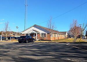
Ocean Township Town Hall
|
||
|
||
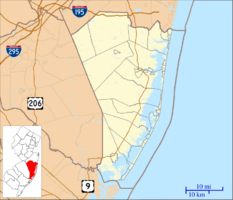
Location of Ocean Township in Ocean County highlighted in yellow (right). Inset map: Location of Ocean County in New Jersey highlighted in black (left).
|
||
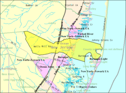
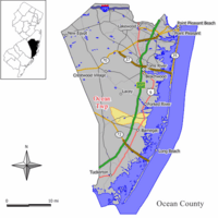
Census Bureau map of Ocean Township, Ocean County, New Jersey
|
||
| Country | ||
| State | ||
| County | ||
| Incorporated | April 13, 1876 | |
| Government | ||
| • Type | Township | |
| • Body | Township Committee | |
| Area | ||
| • Total | 32.81 sq mi (84.97 km2) | |
| • Land | 21.10 sq mi (54.65 km2) | |
| • Water | 11.70 sq mi (30.31 km2) 35.67% | |
| Area rank | 73rd of 565 in state 10th of 33 in county |
|
| Elevation | 59 ft (18 m) | |
| Population
(2020)
|
||
| • Total | 8,835 | |
| • Estimate
(2023)
|
9,027 | |
| • Rank | 268th of 565 in state 13th of 33 in county |
|
| • Density | 423.4/sq mi (163.5/km2) | |
| • Density rank | 453rd of 565 in state 30th of 33 in county |
|
| Time zone | UTC−05:00 (Eastern (EST)) | |
| • Summer (DST) | UTC−04:00 (Eastern (EDT)) | |
| ZIP Code |
08758 – Waretown
|
|
| Area code(s) | 609 exchanges: 242, 693, 971 | |
| FIPS code | 3402954300 | |
| GNIS feature ID | 0882071 | |
Ocean Township is a community on the Jersey Shore in Ocean County, New Jersey. In 2020, about 8,835 people lived here. This was the largest population the township has ever had! The name "Ocean Township" comes from its location near the ocean.
Many people call the entire area "Waretown." This is because Waretown is the main community within Ocean Township. Sometimes, people confuse this Ocean Township with another one in Monmouth County.
Contents
History of Ocean Township
Ocean Township became an official township on April 13, 1876. It was created from parts of Lacey Township and Barnegat Township. Later, parts of Ocean Township were used to form Long Beach Township (in 1899) and Island Beach (in 1933).
How Waretown Got Its Name
The name Waretown comes from Abraham Weair. He came to the area around 1737 with a group of Quaker Baptists. Weair built a sawmill and became an important part of the community.
Ocean Township During Wars
During the American Revolutionary War, British ships sailed near Barnegat Inlet. They wanted to protect their supply ships from local privateers. Privateers were like private ships that attacked enemy vessels. The British also wanted to destroy Newlin's salt works. Salt was very important for preserving food and making gunpowder for the American army.
In 1782, a British loyalist named Captain John Bacon led an attack on Long Beach. This led to a sad event where local patriots were killed.
During the War of 1812, the British returned to Barnegat Inlet. They blocked the Jersey coast. Local privateers were caught, and their ships were burned.
Early Industries and Famous Visitors
In the 1700s and 1800s, Waretown was a center for shipbuilding. They built many types of boats using local white cedar wood. Sea captains built large homes along the bay.
Around 1900, Waretown fishermen sold oysters, clams, and scallops. They sent them to big markets like the Fulton Fish Market in New York City. Other jobs included making charcoal and farming cranberries. People also gathered sphagnum moss for florists.
Waretown became famous for its hunting and fishing. Important people like Presidents Grover Cleveland and William McKinley visited. Even baseball star Babe Ruth and entertainer Buffalo Bill Cody came to hunt and fish.
Ocean Township in World War II
During World War II, large airships called blimps flew along the Jersey coast. They were looking for German U-boats (submarines). Local fishermen reported seeing U-boats close to shore. As a safety step, soldiers were stationed at the Bayview Hotel. This hotel, built in 1890, sadly burned down in 1960.
Geography and Natural Areas
Ocean Township covers about 32.81 square miles (84.97 square kilometers). About 21.10 square miles (54.65 square kilometers) is land, and 11.70 square miles (30.31 square kilometers) is water.
Waretown is a community within Ocean Township. Other small communities here include Brookville, Wells Mills, and Pebble Beach.
Ocean Township shares borders with several other towns in Ocean County. These include Barnegat Light, Barnegat Township, and Lacey Township.
The Pinelands National Reserve
Ocean Township is part of the New Jersey Pinelands National Reserve. This is a special protected natural area. It covers over 1.1 million acres and has unique plants and animals. Congress created it in 1978 as the first National Reserve in the U.S. All of Ocean Township is included in this important natural area.
Population and People
| Historical population | |||
|---|---|---|---|
| Census | Pop. | %± | |
| 1880 | 484 | — | |
| 1890 | 482 | −0.4% | |
| 1900 | 436 | * | −9.5% |
| 1910 | 397 | −8.9% | |
| 1920 | 286 | −28.0% | |
| 1930 | 387 | 35.3% | |
| 1940 | 427 | * | 10.3% |
| 1950 | 520 | 21.8% | |
| 1960 | 921 | 77.1% | |
| 1970 | 2,222 | 141.3% | |
| 1980 | 3,731 | 67.9% | |
| 1990 | 5,416 | 45.2% | |
| 2000 | 6,450 | 19.1% | |
| 2010 | 8,332 | 29.2% | |
| 2020 | 8,835 | 6.0% | |
| 2023 (est.) | 9,027 | 8.3% | |
| Population sources: 1880–2000 1880–1920 1880–1890 1890–1910 1910–1930 1940–2000 2000 2010 2020 * = Lost territory in previous decade. |
|||
In 2010, there were 8,332 people living in Ocean Township. Most residents (about 96.75%) were White. About 2.76% of the population was Hispanic or Latino.
The median age in 2010 was 49.6 years old. About 16.1% of the population was under 18. The average household had 2.39 people. The average family had 2.76 people.
Parks and Fun Activities
Ocean Township has many great parks and places for recreation:
- Waretown Lake and Recreation Area: This park has a swimming lake, tennis courts, and a playground. It also has picnic tables and a covered pavilion.
- Tuomey Park: Here you can find a baseball field, basketball courts, and horseshoe pits. There's also a playground and picnic tables.
- Crystal Bay Peninsula Park: This is a nice spot with benches and picnic tables.
- Waretown Municipal Dock: Located at the end of Bryant Road, this dock is perfect for fishing.
- Sands Point Park/Boat Ramp: This park offers a fishing pier and a boat launch. It also has tennis courts, a playground, and picnic tables.
- Wells Mills County Park: This is the largest county park, covering over 900 acres of Pinelands forest. It has 16 miles of trails for hiking and biking. You can also fish and boat in the freshwater lake. The park has a nature center and an observation deck.
- Barnegat Branch Trail: This trail runs through Ocean Township along an old railroad path. When finished, it will be 15.6 miles long. It's a great place for walking and biking.
Education for Students
Students in Ocean Township attend public schools.
Elementary School
For students in pre-kindergarten through sixth grade, they go to the Ocean Township School District. The district has two schools:
- Waretown Elementary School: For students in Pre-K to 3rd grade.
- Frederic A. Priff Elementary School: For students in grades 4–6.
Middle and High School
For students in seventh through twelfth grades, they attend schools in the Southern Regional School District. This district serves several towns, including Ocean Township.
- Southern Regional Middle School: For students in grades 7–8.
- Southern Regional High School: For students in grades 9–12.
Both of these schools are located in Manahawkin.
Getting Around Ocean Township

Ocean Township has many roads for cars. The Garden State Parkway and U.S. Route 9 both pass through the township. The Parkway connects different towns and has an exit for Waretown.
Public Transportation
NJ Transit provides bus service to and from Atlantic City on the 559 bus route. There is also a local bus service called Ocean Ride. It runs on the Waretown Shoppers Loop route.
Cool Places to Visit
- Albert Music Hall: This place is in the Waretown area. It's sometimes called the "Grand Ol' Opry of the Pinelands." It hosts Saturday night concerts with country, bluegrass, and folk music. The hall started in the 1950s when Joseph and George Albert held music gatherings. In 2000, Albert Music Hall was added to the Library of Congress!
- Lighthouse Center for Natural Resource Education: This center is located on 194 acres of coastal land next to Barnegat Bay. It teaches people about nature and the environment. It has a trail with learning stations and a long pier into Barnegat Bay.
- The Little Red School House and Museum: This building was a school from 1875 to 1958. It was rebuilt near Waretown Lake and is now a museum. It's also where the Waretown Historical Society meets. You can visit it on Fridays in July and August.
Notable People from Ocean Township
Some well-known people have lived in or are connected to Ocean Township:
- Kenneth G. Miller (born 1956): A geologist at Rutgers University.
- George E. Smith (born 1930): He won the Nobel Prize in Physics in 2009 for his work on a special electronic device.
- Sung J. Woo (born 1971): An author.
See also
 In Spanish: Municipio de Ocean (condado de Ocean) para niños
 | Valerie Thomas |
 | Frederick McKinley Jones |
 | George Edward Alcorn Jr. |
 | Thomas Mensah |


