Lacey Township, New Jersey facts for kids
Quick facts for kids
Lacey Township, New Jersey
|
||
|---|---|---|
|
Township
|
||
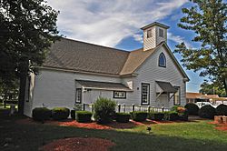
Lacey Schoolhouse Museum
|
||
|
||
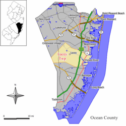
Location of Lacey Township in Ocean County highlighted in yellow (right). Inset map: Location of Ocean County in New Jersey highlighted in black (left).
|
||
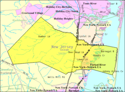
Census Bureau map of Lacey Township, New Jersey
|
||
| Country | ||
| state | ||
| County | ||
| Incorporated | March 23, 1871 | |
| Named for | John Lacey | |
| Government | ||
| • Type | Township | |
| • Body | Township Committee | |
| Area | ||
| • Total | 99.81 sq mi (258.49 km2) | |
| • Land | 83.25 sq mi (215.62 km2) | |
| • Water | 16.55 sq mi (42.87 km2) 16.58% | |
| Area rank | 5th of 565 in state 2nd of 33 in county |
|
| Elevation | 72 ft (22 m) | |
| Population
(2020)
|
||
| • Total | 28,655 | |
| • Estimate
(2023)
|
29,714 | |
| • Rank | 85th of 565 in state 7th of 33 in county |
|
| • Density | 344.2/sq mi (132.9/km2) | |
| • Density rank | 466th of 565 in state 31st of 33 in county |
|
| Time zone | UTC−05:00 (Eastern (EST)) | |
| • Summer (DST) | UTC−04:00 (Eastern (EDT)) | |
| ZIP Codes |
08731 – Forked River
08734 – Lanoka Harbor |
|
| Area code(s) | 609 exchanges: 242, 693, 971 | |
| FIPS code | 3402937380 | |
| GNIS feature ID | 0882072 | |
| Website | ||
Lacey Township is a town in Ocean County, New Jersey. It's part of the Jersey Shore and South Jersey areas. It's also considered part of the larger New York metropolitan area.
In 2020, about 28,655 people lived in Lacey Township. This was a small increase from 2010. The town is named after Continental Army General John Lacey.
Lacey Township became an official town on March 23, 1871. It was formed from parts of other nearby towns. Later, a small part of it became Island Beach State Park. General John Lacey, who the town is named after, also started a business called Ferrago Forge in 1809.
The Oyster Creek Nuclear Generating Station was located in the southern part of the township. This power plant produced electricity for New Jersey. It was the oldest nuclear power plant still running in the United States. It closed in September 2018. The plant used to provide a lot of tax money for the township's budget.
Murray Grove is a special retreat center in Lanoka Harbor. Many people believe that Universalism in America first started here.
Contents
Geography of Lacey Township
Lacey Township covers about 99.81 square miles (258.49 square kilometers). Most of this area is land, but about 16.55 square miles (42.87 square kilometers) is water.
Communities in Lacey Township
Forked River is a community within Lacey Township. About 5,244 people lived there in 2010. Other smaller communities in the township include Bamber Lake and Lanoka Harbor. The fire stations in Lacey Township are named after these different areas.
Lacey Township shares borders with several other towns in Ocean County. These include Barnegat Township and Berkeley Township. It also borders Woodland Township in Burlington County.
Pine Barrens and the Parkway
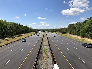
The Garden State Parkway runs through Lacey Township. It acts like a natural border. East of the Parkway, you'll find most of Lacey's homes. These are mainly in Forked River and Lanoka Harbor.
West of the Parkway, there's a large, untouched forest. This forest is part of New Jersey's huge Pine Barrens. Building new things in this forest is very strict. This is because of a law called the Pinelands Protection Act.
Local Pronunciation
Some people in Ocean County call all of Lacey Township "Forked River." They say "FOR-kid" or "FORK-id" for the first word. If you say it with only one syllable, people might know you're not from around here!
In a 2015 poll, Lacey Township was voted as part of South Jersey. It's considered the northernmost Jersey Shore community in South Jersey.
Population of Lacey Township
| Historical population | |||
|---|---|---|---|
| Census | Pop. | %± | |
| 1880 | 814 | — | |
| 1890 | 711 | −12.7% | |
| 1900 | 718 | 1.0% | |
| 1910 | 602 | −16.2% | |
| 1920 | 504 | −16.3% | |
| 1930 | 692 | 37.3% | |
| 1940 | 752 | * | 8.7% |
| 1950 | 966 | 28.5% | |
| 1960 | 1,940 | 100.8% | |
| 1970 | 4,616 | 137.9% | |
| 1980 | 14,161 | 206.8% | |
| 1990 | 22,141 | 56.4% | |
| 2000 | 25,346 | 14.5% | |
| 2010 | 27,644 | 9.1% | |
| 2020 | 28,655 | 3.7% | |
| 2023 (est.) | 29,714 | 7.5% | |
| Population sources:1880–2000 1880–1920 1880–1890 1890–1910 1910–1930 1940–2000 2000 2010 2020 * = Lost territory in previous decade. |
|||
What the 2010 Census Showed
In 2010, there were 27,644 people living in Lacey Township. Most of the people (96.15%) were White. About 4.74% of the population was Hispanic or Latino.
The average age of people in Lacey Township was 41.3 years old. About 23.1% of the population was under 18 years old.
Economy in Lacey Township
Lacey Township has many businesses. The Oyster Creek Nuclear Generating Station used to be the biggest employer. It closed in 2018.
In the early 2000s, Lacey Township grew quickly. Many new stores were built. Before this, people had to travel to other towns to shop at large stores.
There have been some local discussions about new buildings and land use. For example, there was a plan to build a road behind the ShopRite store. Also, there were concerns about enough water for new stores like Home Depot and Walmart.
Arts and Culture in Lacey Township
Old Schoolhouse Museum
The Old Schoolhouse Museum is a small, historic building. It was built in the mid-1800s. It was the first school in Forked River. It was used as a school until 1954.
Lacey Lights Boat Parade
The town used to have an event called "Night of Lights." It was a boat parade on the Forked River in August. Boat owners decorated their boats with lights. They would sail down the river at night. Now, it's called the Lacey Lights Boat Parade. Local businesses and groups help put it on.
Parks and Recreation in Lacey Township
Popcorn Park Zoo
Popcorn Park Zoo is a small zoo, about 7 acres (28,000 square meters) in size. It has many different animals. You can see big cats, monkeys, and black bears there. The zoo started in 1977.
Local Parks and Activities
Lacey Township has several parks, including Clune, Gille, Hebrew, and Huffy Wallis parks.
A large part of Double Trouble State Park is in Lacey Township. This park is about 8,500 acres (34 square kilometers). However, its main entrance is in a nearby town.
Robert J. Miller Air Park, also known as the Ocean County Airport, is partly in Lacey Township. Its main entrance is also in Berkeley Township.
The Forked River State Marina is in Lacey. It has 125 places for boats to dock.
Tices shoal is a popular spot for boaters in the summer. It's on the bay side of Island Beach State Park. The water there is shallow, and it's close to the Atlantic Ocean. You can reach Island Beach State Park and the Barnegat Inlet by boat from Lacey Township.
Education in Lacey Township
The Lacey Township School District serves students from kindergarten through twelfth grade. In the 2021–22 school year, about 3,864 students attended the six schools in the district.
The schools are:
- Mill Pond Elementary School (grades PreK-K)
- Cedar Creek Elementary School (grades 1-5)
- Forked River Elementary School (grades 1-5)
- Lanoka Harbor Elementary School (grades 1-5)
- Lacey Township Middle School (grades 6-8)
- Lacey Township High School (grades 9-12)
St. Mary Academy is a private Catholic school for grades K-8. It is located in Manahawkin. St. Pius X Church in Lacey Township used to help manage this school.
Media in Lacey Township
You can read daily news about Lacey Township in the Asbury Park Press and The Press of Atlantic City. WOBM-FM radio also provides news.
The Southern Ocean Times is a weekly newspaper that covers Lacey Township. It also covers other nearby towns.
Both New York City and Philadelphia TV stations provide news coverage for the township. This is because the media areas for both cities overlap in Ocean County.
Transportation in Lacey Township
Roads and Highways
As of 2010, Lacey Township had about 194.40 miles (312.86 kilometers) of roads. Most of these roads are kept up by the township itself.
The Garden State Parkway goes through Lacey Township. It connects Ocean Township to Berkeley Township. There's a service area at milepost 76 on the Parkway. You can also get off at Exit 74 for Forked River and Waretown.
U.S. Route 9 also runs through the eastern part of the township. County Route 539 passes through the western area.
Public Transportation
NJ Transit offers bus service from Lacey Township to Atlantic City. This is on the 559 bus route.
Academy Bus has special routes from the Forked River Service Area. These buses go to Midtown Manhattan or Wall Street in Lower Manhattan. There's also a local bus service called Ocean Ride OC5 Lacey.
There are no train services directly in Lacey Township. In the past, several railroads served the area. Today, the closest train stations are in Bay Head and Absecon.
Notable People from Lacey Township
Many interesting people have lived in or are connected to Lacey Township:
- Christopher J. Connors (born 1956), a politician who serves in the New Jersey Senate.
- Tom DeBlass (born 1982), a professional mixed martial artist.
- Keith Elias (born 1972), a former National Football League player for the New York Giants.
- Chris Fleming (born 1970), a basketball player and coach for the Brooklyn Nets.
- Mark Leiter Jr. (born 1991), a baseball pitcher.
- Thomas Potter (1689–1777), a farmer who built a chapel in 1760 to spread the idea of Universalism.
- Rhett Titus (born 1987), a professional wrestler.
- Alex Wojciechowicz (1915–1992), a famous football player who is in both the College and Pro Football Halls of Fame.
See also
 In Spanish: Municipio de Lacey (Nueva Jersey) para niños
 | Claudette Colvin |
 | Myrlie Evers-Williams |
 | Alberta Odell Jones |


