Oheyawahi-Pilot Knob facts for kids
Quick facts for kids |
|
|
Oheyawahi-Pilot Knob
|
|

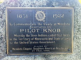
DAR marker at Oheyawahi-Pilot Knob
|
|
| Location | Off MN 55 at the north end of Pilot Knob road, Mendota Heights, Dakota County, Minnesota |
|---|---|
| NRHP reference No. | 03001374_R |
| Added to NRHP | March 14, 2017 |
Oheyawahi-Pilot Knob is a special place in Mendota Heights, Minnesota. It's a beautiful spot with amazing views, a gathering place for Native American people, and a burial ground. From here, you can see where the Minnesota and Mississippi Rivers meet. You can also spot Fort Snelling and the city skylines of Minneapolis and St. Paul.
This historic site was where the important Treaty of Mendota was signed in 1851. This treaty was between the United States government and the Dakota people of Minnesota. In 2017, Oheyawahi-Pilot Knob was officially added to the National Register of Historic Places. This means it's recognized as a very important historical site.
Contents
A Sacred Place for Centuries
The name Oheyawahi comes from the Dakota language. It means "a sacred place much visited" or "the place where people go for burials." For a very long time, this hill has been a sacred spot for the Dakota people.
Early explorers and settlers wrote about how important this place was.
- In the 1830s, Charles La Trobe described a tomb of an Indian chief at the top of the hill.
- French explorer Joseph Nicollet saw a "great gathering of people" and a Dakota medicine dance there in 1837.
- Mary Henderson Eastman wrote that Pilot Knob was "proud to be the burial place of her warrior children."
- French settlers even called the hill La Butte des Morts, which means Knoll of the Dead.
Scientists have found human remains on the hill. These findings support the idea that both Native American and European people were buried here.
How Pilot Knob Got Its Name
In the 1800s, this hill became a helpful landmark for riverboat pilots. They used it to find their way along the Minnesota River. This is how the hill got its other name, Pilot Knob.
A Capital Idea?
In 1848, a senator named Stephen A. Douglas from Illinois had an idea. He thought Mendota Heights, with Pilot Knob, would be a great place for Minnesota’s territorial capital. He said Pilot Knob would be a "grand place for the capitol building" because of its "beautiful and extensive view." However, the capital was eventually built in St. Paul. This happened because Henry Hastings Sibley, who became Minnesota's first governor, pushed for St. Paul instead.
The Treaty of Mendota
A very important event happened at Pilot Knob in 1851. This was the signing of the Treaty of Mendota. Through this treaty, the Dakota people gave up about 25 million acres (10 million hectares) of land to the U.S. government. This land was west of the Mississippi River and covered much of southern Minnesota.
A Difficult Time
During the Dakota War of 1862, many Dakota people were forced into a camp on nearby Pike Island. Sadly, many Dakota people died that winter. Some of them were buried on Pilot Knob.
Modern Efforts to Protect the Site
For many years, the land around Pilot Knob remained mostly undeveloped. But in 1925, 140 acres (57 hectares) were bought to create Acacia Park Cemetery. During the work to build the cemetery, the top 20 feet (6 meters) of the hill were removed.
Saving Pilot Knob
In 2002, a company planned to build many houses on 27 acres (11 hectares) of the hill. This plan caused a lot of concern. People from the Dakota and Ojibwe communities, scientists, environmental groups, historians, and local residents all spoke out against it.
This led to the creation of a group called the Pilot Knob Preservation Association. Their goal was to protect the site and make sure it was recognized as an important cultural and historical place.
Working together, several groups helped save the land:
- The Trust for Public Land bought 8.5 acres (3.4 hectares) in 2005.
- They then sold it to the City of Mendota Heights.
- The city, along with the Trust, the Minnesota Department of Natural Resources, Dakota County, and the Pilot Knob Preservation Association, all contributed money for the purchase.
- The city bought another 25 acres (10 hectares) between 2006 and 2008.
Restoring the Land
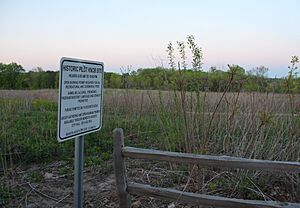
Today, the 25 acres (10 hectares) that the city owns (plus 9 acres they already had) are being restored. A local group called Great River Greening is working to turn the area back into an oak savanna. This is a type of grassland with scattered oak trees, like it used to be.
To help with this, they even use horses, goats, and sheep! These animals help keep the native grasslands healthy.
There are now trails at Pilot Knob, including three spots with great views. These trails connect to the Big Rivers Regional Trail. The site is also located within the Mississippi Flyway. This is a major route that many birds use when they migrate from central Canada to the Gulf of Mexico.
National Recognition
In 2017, the 125-acre (51-hectare) historic site was added to the NRHP. This includes both public and private land, the cemetery, and some homes.
From Pilot Knob, you can look out over Pike Island, where the Mississippi and Minnesota rivers join. You can also see Fort Snelling, Saint Peter's Church (the oldest church in Minnesota), and the Mendota Bridge on Minnesota State Highway 55. In the distance, the tall buildings of Minneapolis and Saint Paul are easy to see.
Pilot Knob Road goes up the south side of the Oheyawahi-Pilot Knob hill. It passes Acacia Park Cemetery at the top and then ends just over the hilltop. In the other direction, Pilot Knob Road continues south to Dakota County 50/212th St W, near the towns of Lakeville and Farmington.
 | Stephanie Wilson |
 | Charles Bolden |
 | Ronald McNair |
 | Frederick D. Gregory |


