Ollantaytambo facts for kids
Quick facts for kids
Ollantaytambo
Ullantaytampu
|
|||
|---|---|---|---|
|
Town
|
|||

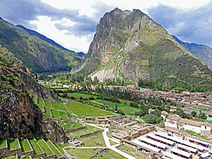
View from the top of the Ollantaytambo Ruins
|
|||
|
|||
| Country | |||
| Region | Cusco | ||
| Province | Urubamba | ||
| District | Ollantaytambo | ||
| Elevation | 2,792 m (9,160 ft) | ||
| Population
(2017)
|
|||
| • Total | 3,050 | ||
| Time zone | UTC-5 (PET) | ||
Ollantaytambo (called Ullantaytampu in the native language) is a cool town and an ancient Inca site in southern Peru. It's about 72 km (45 mi) (45 miles) northwest of the city of Cusco. This town sits high up in the mountains, about 2,792 m (9,160 ft) (9,160 feet) above sea level. It's part of the Ollantaytambo district in the Urubamba province, within the Cusco region.
Long ago, when the Inca Empire was powerful, Ollantaytambo was a special place for Emperor Pachacuti. He conquered the area and built the town and a ceremonial center here. Later, when the Spanish arrived, it became a strong fort for Manco Inca Yupanqui, who led the Inca people fighting back. Today, Ollantaytambo is in the beautiful Sacred Valley of the Incas. It's a popular spot for tourists because of its amazing Inca ruins. It's also a common starting point for the famous Inca Trail hike to Machu Picchu.
Contents
History of Ollantaytambo
Around the mid-1400s, the Inca emperor Pachacuti took over Ollantaytambo. He made the town and the land around it part of his own personal property. The emperor rebuilt the town with impressive buildings. He also created many terraces and irrigation systems in the Urubamba Valley.
The town provided homes for important Inca nobles. The terraces were farmed by yanakuna, who were like personal helpers to the emperor. After Pachacuti passed away, his family group, called a panaqa, took care of the estate.
Ollantaytambo During the Spanish Conquest
During the Spanish conquest of Peru, Ollantaytambo became a temporary capital for Manco Inca. He was the leader of the Inca people who resisted the Spanish. Manco Inca made the town and its paths stronger, especially those leading from the old Inca capital of Cusco, which the Spanish now controlled.
In 1536, near Ollantaytambo, Manco Inca won a battle against the Spanish. This was called the Battle of Ollantaytambo. He used high terraces to block their advance and even flooded the plain. Even though he won, Manco Inca felt the location wasn't safe enough. So, the next year, he moved to a heavily forested area called Vilcabamba. There, he set up a new Inca state, called the Neo-Inca State.
In 1540, the Spanish gave the native people of Ollantaytambo to Hernando Pizarro as part of a system called encomienda.
Modern Discoveries
In the 1800s, the Inca ruins at Ollantaytambo caught the eye of many explorers from other countries. People like Clements Markham, Ephraim Squier, Charles Wiener, and Ernst Middendorf wrote about what they found.
Hiram Bingham III visited Ollantaytambo in 1911. He was on his way up the Urubamba River looking for the lost city of Machu Picchu.
What Ollantaytambo Looks Like
The town of Ollantaytambo is located along the Patakancha River. This river joins the Willkanuta River nearby. The main part of the town is on one side of the Patakancha. A smaller area called 'Araqhama is on the other side. The main Inca ceremonial center is on a hill called Cerro Bandolista, past 'Araqhama. There are also many other Inca structures in the areas around the town.
The Town's Design
The main part of Ollantaytambo town has a grid-like plan. It has four long streets crossed by seven parallel streets. In the middle of this grid, the Incas built a large open area, like a plaza. This plaza might have been as big as four city blocks. It was open to the east and surrounded by buildings on its other three sides.
All the blocks in the southern half of the town were built in the same way. Each one had two kanchas. These were walled areas with four one-room buildings around a central courtyard. Buildings in the northern half are more varied. However, many are in such poor condition that their original design is hard to figure out.
Ollantaytambo was built in the late 1400s. It has some of the oldest homes in South America that have been lived in continuously. Its layout and buildings have changed over time due to new constructions. For example, the original entrance to the town was an Inca open space on the southern edge. This was later rebuilt as a Plaza de Armas with colonial and modern buildings around it. The central plaza also disappeared as new buildings were built over it during colonial times.
'Araqhama is an area west of the main town, across the Patakancha River. It has a large plaza called Manyaraki. This plaza is surrounded by buildings made of adobe (mud brick) and partly cut stones. These buildings are much larger than those in the main town. They also have very tall walls and huge doors. To the south are smaller structures made of rough fieldstones. 'Araqhama has been lived in since Inca times. You can see this from the Roman Catholic church on the east side of the plaza. North of Manyaraki are several special places with carved stones, sculpted rock faces, and fancy water systems. These include the Templo de Agua (Water Temple) and the Baño de la Ñusta (Bath of the Princess).
Temple Hill: A Sacred Place
'Araqhama is next to Cerro Bandolista, a steep hill where the Incas built a ceremonial center. The part of the hill facing the town has the terraces of Pumatallis. These are framed by rock outcrops on both sides. Because these terraces look so impressive, people often call Temple Hill "the Fortress." However, this is not quite right, as the main purpose of this site was religious.
To get to the ceremonial center, you climb a series of stairways to the top of the terraces. At the top, the site is divided into three main areas: the Middle sector, the Temple sector (to the south), and the Funerary sector (to the north).
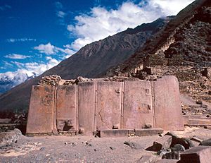
The Temple sector is built with carefully cut and fitted stones. This is different from the other two sectors, which use rough fieldstones. You enter the Temple sector by a stairway that leads to a terrace. This terrace has a half-finished gate and a building called the Enclosure of the Ten Niches. Behind these is an open space with the Platform of the Carved Seat and two unfinished huge walls. The most important building in this sector is the Sun Temple. It's an unfinished building with the famous Wall of the Six Monoliths. The Middle and Funerary sectors have several rectangular buildings, some with two floors. There are also several fountains in the Middle sector.
The unfinished buildings and many stone blocks scattered around Temple Hill show that it was still being built when it was abandoned. Some blocks even look like they were removed from finished walls, meaning a big redesign was happening too. No one knows for sure why construction stopped. It could have been because of the Inca Civil War between Huáscar and Atahualpa, the Spanish Conquest, or when Manco Inca left Ollantaytambo for Vilcabamba. Some people also think the work might have been done by an older culture called Tiwanaku.
Amazing Terraces
The valleys of the Urubamba and Patakancha Rivers around Ollantaytambo are covered with many agricultural terraces, also called andenes. These terraces start at the bottom of the valleys and climb up the hills. The andenes allowed the Incas to farm on land that would otherwise be unusable. They also helped the Incas use different climate zones created by changes in height.
The terraces at Ollantaytambo were built very well, better than typical Inca farm terraces. For example, their walls are taller and made of cut stones, not rough fieldstones. This type of fancy terracing is also found in other Inca royal estates like Chinchero, Pisaq, and Yucay.
South of Ollantaytambo's main plaza, a set of sunken terraces stretches all the way to the Urubamba River. They are about 700 meters (2,300 feet) long and 60 meters (200 feet) wide. They are also up to 15 meters (50 feet) lower than the surrounding terraces. Because of their shape, they are called Callejón, which means "alley" in Spanish.
The land inside Callejón is protected from the wind by its side walls. These walls also soak up sunlight during the day and release heat at night. This creates a special mini-climate that is 2 to 3 degrees Celsius (3.6 to 5.4 degrees Fahrenheit) warmer than the ground above it. These conditions allowed the Incas to grow plants that usually grow in lower, warmer areas, which otherwise couldn't have grown here.
At the southern end of Callejón, overlooking the Urubamba River, is an Inca site called Q'ellu Raqay. Its connected buildings and plazas have an unusual design. It's very different from the single-room buildings common in Inca architecture. Since the site is separate from the rest of Ollantaytambo and surrounded by fancy terraces, some believe it was a palace built for Emperor Pachacuti.
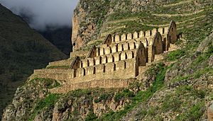
Inca Storehouses

The Incas built several storehouses, called qullqas (or qollqa), out of fieldstones on the hills around Ollantaytambo. They placed them high up where there is more wind and cooler temperatures. This helped protect the stored food from going bad. To make this even better, the Ollantaytambo qullqas have special ventilation systems. People think they were used to store the food grown on the agricultural terraces around the site. Grain would be poured in through windows on the uphill side of each building. Then, it would be emptied out through windows on the downhill side.
Ancient Quarries
The main stone quarries for Ollantaytambo were at Kachiqhata. This is in a ravine across the Urubamba River, about 5 kilometers (3 miles) from the town. The site has three main quarrying areas: Mullup'urku, Kantirayoq, and Sirkusirkuyoq. All of them provided blocks of rose rhyolite stone for the detailed buildings of Temple Hill. A complex network of roads, ramps, and slides connected the quarries to the main building areas. In the quarries, you can also find several chullpas, which are small stone towers used as burial sites in ancient times.
Ollantaytambo's Defenses

Ollantaytambo is surrounded by mountains. The main ways to get there are along the Urubamba Valley. The Incas built roads connecting the site to Machu Picchu in the west and Pisaq in the east.
During the Spanish conquest of Peru, Emperor Manco Inca made the eastern paths stronger. He did this to stop Spanish attacks from Cusco during the Battle of Ollantaytambo. The first line of defense was a steep bank of terraces at Pachar. This was near where the Anta and Urubamba Rivers meet. Behind this, the Incas changed the Urubamba River's path. They made it cross the valley back and forth, creating two more lines of defense. These were supported by forts called Choqana on one side and 'Inkapintay on the other.
Past these, on the plain of Mascabamba, 11 high terraces blocked the valley between the mountains and a deep canyon made by the Urubamba River. The only way to continue was through the gate of T'iyupunku. This was a thick defensive wall with two narrow doorways. To the west of Ollantaytambo, a small fort called Choquequillca protected the road to Machu Picchu. If these defenses were ever broken, Temple Hill itself, with its high terraces, would be the last line of defense against invaders.
Gallery
See also
 In Spanish: Ollantaytambo para niños
 | James Van Der Zee |
 | Alma Thomas |
 | Ellis Wilson |
 | Margaret Taylor-Burroughs |


