Omaha Reservation facts for kids
Quick facts for kids
Omaha Reservation
|
||
|---|---|---|
|
||

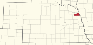
Location of the Omaha Reservation in Nebraska
|
||
| Tribe | Omaha | |
| Country | United States | |
| State | Nebraska and Iowa | |
| County | Thurston County, Nebraska, Cuming County, Nebraska, Burt County, Nebraska and Monona County, Iowa | |
| Headquarters | Macy | |
| Area | ||
| • Total | 309.993 sq mi (802.88 km2) | |
| • Land | 307.032 sq mi (795.21 km2) | |
| • Water | 2.961 sq mi (7.67 km2) | |
| Population
(2020)
|
||
| • Total | 4,526 | |
| • Density | 14.7/sq mi (5.7/km2) | |
| Website | Omaha Tribe of Nebraska | |
The Omaha Reservation (in the Omaha language: Umoⁿhoⁿ tóⁿde ukʰéthiⁿ) is a special area of land. It belongs to the Omaha Tribe, a group of Native Americans recognized by the US government. Most of the reservation is in Thurston County, Nebraska. Smaller parts are in Cuming and Burt counties in Nebraska. There is also a small section in Monona County, Iowa.
In 2020, about 4,526 people lived on the reservation. The main government office for the tribe is in Macy. Other towns like Rosalie, Pender, and Walthill are also within the reservation's borders. Even the northern part of Bancroft is included. There have been disagreements about whether Pender is fully part of the reservation. In 2016, the Supreme Court decided that Pender is indeed inside the reservation's boundaries.
Contents
History of the Omaha Reservation
The Omaha Reservation was created a long time ago. This happened through a special agreement called a treaty. The treaty was signed in Washington, D.C., on March 16, 1854. In this agreement, the Omaha Nation sold most of their land west of the Missouri River to the United States.
However, the treaty allowed the Omaha to choose a large area of land to keep. This land would be their permanent reservation. The Omaha Nation picked an area near the Blackbird Hills. The President of the United States approved their choice on May 11, 1855.
Changes to Reservation Land
Later, in another treaty on March 6, 1865, the Omaha Nation agreed to sell part of their northern land. This land was for the Ho-Chunk people, also known as the Winnebago Tribe of Nebraska. They were moving from another reservation in South Dakota. This sale created the Winnebago Reservation just north of the Omaha Reservation.
The Omaha later gave even more land to the Winnebago Reservation. This happened through a law passed by Congress on June 22, 1874. This reduced the Omaha Reservation to its current size.
Land Sales to Settlers
In the late 1800s, new laws allowed parts of the reservation to be divided up. This process was called "allotment." It made it possible for white settlers to buy much of the land on the reservation. A law in 1872 allowed land on the western side of the reservation to be sold. But not many people bought it at first.
In 1882, another important law was passed. This law was influenced by a person named Alice Cunningham Fletcher. It divided the eastern part of the reservation into individual plots for Omaha tribal members. It also allowed land west of the railroad to be sold to settlers. Fletcher helped give out these land plots. She gave about 76,810 acres to 954 tribal members. About 55,000 acres remained under tribal ownership.
The 1882 law for the Omaha Reservation was a model for a bigger law. This bigger law was called the Dawes Act of 1887. It allowed similar land divisions on reservations all over the country. More land was divided in 1893 for Omaha women and children.
Disputes Over Land and Taxes
Selling reservation land led to many disagreements. These were about who had power over the land. The Omaha Nation and the government of Thurston County often disagreed. Thurston County is completely inside the Omaha and Winnebago reservations.
In 1916, a special law allowed the county to charge property taxes on Omaha land. This forced many tribal members to sell their land to pay these taxes. The county kept taxing tribal land until the 1970s. Then, courts ruled that the tribe could not be taxed without their permission.
Geography of the Reservation
The Omaha Reservation covers about 309.99 square miles (802.87 square kilometers). Most of this area is land, about 307.03 square miles (795.20 square kilometers). The rest is water, about 2.96 square miles (7.67 square kilometers).
Because of the land divisions in the late 1800s, much of the reservation land is not owned by the tribe anymore. The Omaha Nation's trust land, which is land held by the US government for the tribe, is about 27,828 acres (112.61 square kilometers). This is about 14.2% of the total reservation land.
People Living on the Reservation
In 2020, the Omaha Reservation had a population of 4,526 people. This means there were about 14.7 people living per square mile. There were 1,563 homes on the reservation.
The people living on the reservation come from different backgrounds:
- About 47.6% were Native American.
- About 47.5% were White.
- Smaller numbers were Asian, Black, or Pacific Islander.
- About 1.6% were from other backgrounds.
- About 2.7% were from two or more backgrounds.
- About 4.1% of the population was Hispanic or Latino.
Disputes Over Boundaries
The exact borders and who has power over certain areas have been ongoing issues for the Omaha Indian Reservation. In the late 1800s, Congress allowed land sales to non-Omaha people. These sales happened in the western part of the reservation where European-American farmers had settled. Because of these sales, a Nebraska state court decided in 2000 that the reservation's western border ended at railroad tracks east of Pender, Nebraska.
The Omaha Tribe believes that Pender is still under their authority. They say that Congress never changed the reservation's original borders. These borders include most of Thurston County. The tribe argues that even though land was sold, their power within the reservation boundaries did not shrink. The Supreme Court has said that only Congress can make a reservation smaller.
There have been many issues about tribal authority in Pender and other western areas. For example, in 2003, tribal police tried to stop non-Omaha people from entering the reservation from Pender. The tribe and the state talked about policing in this area, but they did not reach an agreement. Before this time, the state usually handled policing on the roads and in Pender.
On March 22, 2016, the United States Supreme Court made a clear decision. They ruled that Pender is indeed within the reservation's boundaries.
Current Issues on the Reservation
In December 2006, the Omaha Tribe told businesses in Pender, Rosalie, and Walthill about new rules. Starting January 1, 2007, these businesses would need to pay the Omaha Tribe for business permits and a 10 percent sales tax. This was required to continue operating within the reservation.
An attorney for the tribe explained that the tribe has the legal right to make such laws on its reservation. The Nebraska Attorney General agreed that the Omaha Tribe had the power to regulate businesses on its reservation. He also said it did not interfere with the state's business commission.
In April 2007, businesses in Pender filed a lawsuit. They challenged the tribe's right to collect these taxes. They argued that Pender was outside the reservation boundaries. In October 2007, a federal court told the businesses to first take their challenge to the Omaha Tribal Courts. This is a common legal step. The judge wanted to hear the tribal court's opinion. He also ordered a temporary pause on the businesses paying the sales tax while the case was ongoing.
In January 2012, the businesses asked the Omaha Tribal Courts to make a quick decision. The case had been going on for a long time. The village of Pender had even voted in 2008 for a special sales tax. This tax was to help pay for their lawsuit about the boundary and business taxes. Residents voted again in May 2012 on whether to continue this sales tax, as the boundary issue was still not fully settled.
See also
 In Spanish: Reserva india Omaha para niños
 | Frances Mary Albrier |
 | Whitney Young |
 | Muhammad Ali |


