
Pacific Northwest water resource region facts for kids
The Pacific Northwest water resource region is one of 21 big areas in the United States that help us understand how water flows across the country. Think of it like a giant map where each section shows where all the rain and snow eventually ends up – usually in a major river or a group of rivers.
This special region, known by a code of 17, is super big! It covers about 302,334 square miles (783,040 square kilometers) of land. Inside this huge area, there are 12 smaller sections, kind of like neighborhoods within a city, each with its own specific water flow.
The Pacific Northwest region includes all the water that eventually flows into the Strait of Georgia and the Strait of Juan de Fuca, as well as the Pacific Ocean in Oregon and Washington. It also includes a part of the Great Basin that drains into Oregon. This means it covers all of Washington and parts of California, Idaho, Montana, Nevada, Oregon, Utah, and Wyoming.
Understanding Water Regions
Water resource regions are like big puzzle pieces that the United States Geological Survey (a science agency) uses to study water. They help scientists and planners understand how water moves across the land, where it comes from, and where it goes. This is really important for managing water for drinking, farming, and nature.
Each region has a special code. The Pacific Northwest region has the code 17. Within this region, there are even smaller areas called subregions, each with its own 4-digit code (like 1701, 1702, and so on). These smaller areas help us look at water in more detail.
Where the Water Flows
The Pacific Northwest is famous for its many rivers and its beautiful coastline. The water in this region eventually makes its way to the Pacific Ocean.
Here are some of the main places the water from this region ends up:
- Strait of Georgia and Strait of Juan de Fuca: These are large bodies of water between the United States and Canada.
- Pacific Ocean: The vast ocean along the coasts of Oregon and Washington.
- Great Basin: A unique area where water doesn't flow to the ocean but instead drains into lakes or disappears into the ground. A part of this basin in Oregon is included in the Pacific Northwest water region.
This region is home to many important rivers, like the mighty Columbia River and the Snake River, which are vital for the environment, wildlife, and people living there.
Images for kids
-
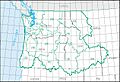
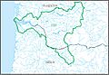
The Pacific Northwest region, with its 12 4-digit subregion hydrologic unit boundaries.
-
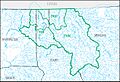
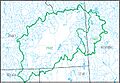
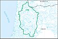
Map of the Kootenai–Pend Oreille–Spokane subregion (1701).
-
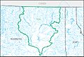
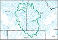
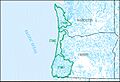
Map of the Upper Columbia subregion (1702).
-
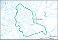
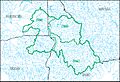
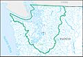
Map of the Yakima subregion (1703).
-
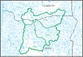
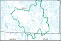
Map of the Upper Snake subregion (1704).
-
Map of the Middle Snake subregion (1705).
-
Map of the Lower Snake subregion (1706).
-
Map of the Middle Columbia subregion (1707).
-
Map of the Lower Columbia subregion (1708).
-
Map of the Willamette subregion (1709).
-
Map of the Oregon–Washington Coastal subregion (1710).
-
Map of the Puget Sound subregion (1711).
-
Map of the Oregon closed basins subregion (1712).


