
Paniri facts for kids
Quick facts for kids Paniri |
|
|---|---|
 |
|
| Highest point | |
| Elevation | 5,960 m (19,550 ft) |
| Prominence | 1,653 m (5,423 ft) |
| Parent peak | San Pedro |
| Listing | Ultra |
| Geography | |

Paniri
Location in Chile
|
|
| Location | Antofagasta, Chile |
| Parent range | Andes |
| Geology | |
| Mountain type | Stratovolcano |
| Last eruption | Unknown |
| Climbing | |
| First ascent | pre-Columbian |
Paniri is a large volcano located in Chile, close to the border with Bolivia. Its name comes from the Aymara language, meaning "he who comes, visits." Paniri is a type of volcano called a stratovolcano, which means it's tall and cone-shaped, built up by many layers of hardened lava and ash.
Near Paniri, you can find other volcanoes like San Pedro and San Pablo. To its southeast is Cerro del León, separated by a huge lava dome called Chao.
Paniri has visible lava flows, especially on its southern side. It also has a small, cone-shaped hill made of volcanic rock called a scoria cone at its top. The volcano has three craters (bowl-shaped openings). Paniri also shows signs that glaciers once covered parts of its southeastern slope.
Scientists believe Paniri formed in several steps. The first step created a wide, shield-like base. Later steps built up the cone shape we see today. The youngest part of the volcano is about 150,000 years old.
Paniri is part of a group of volcanoes called the San Pedro-Linzor volcanic chain. This chain was formed by lava and ash flows. The rocks from Paniri are made of different materials, from basaltic andesite to dacite.
Contents
Where is Paniri Located?
Paniri is found in the Antofagasta Province of Chile. It sits between Cerro Carcanal to the west and Cerro del Leon to the east. Roads go around the northern and western sides of the volcano. The large lava flow of Cerro Chao is next to Paniri on its southeast side. Small towns like Cupo and Turi are located to the west and south of Paniri.
Paniri is part of a larger group of volcanoes called the Central Volcanic Zone. This zone is a long line of volcanoes in the Andes mountains. Other famous volcanoes in this area include Lascar and Ubinas. There are also places with hot springs and geysers, like El Tatio.
What Does Paniri Look Like?
Paniri has two main parts and three craters at its top. One of these craters even holds a small lake, which is about 6 by 12 meters (about 20 by 40 feet) in size. The very top of the volcano has a scoria cone.
Thick lava flows spread out from the summit, forming the base of Paniri. Deep channels called gullies cut into its sides. Around the summit, you can see piles of rock and dirt called moraines, which were left behind by ancient glaciers.
How Did Paniri Form?
The Earth's surface is made of huge pieces called tectonic plates. Since the time of the Jurassic period (when dinosaurs lived), one of these plates, the Nazca Plate, has been slowly sliding under the western side of South America. This process, called subduction, causes the volcanoes in the Central Volcanic Zone of the Andes, including Paniri.
Most of Paniri formed during the Pleistocene Ice Age. However, some parts of the volcano look very fresh, which suggests it might still be active. Other parts of the volcano have been shaped by glaciers and hot water, and salt deposits have formed at its base.
Paniri sits on older layers of rock, including ancient sediments and volcanic ash from other eruptions. Paniri grew along with other volcanoes like Cerro Chao in a line called the San Pedro-Linzor complex. This line of volcanoes might exist because of a crack in the Earth's crust.
The rocks that Paniri has erupted are made of different materials, from basaltic andesite to rhyolite. These rocks contain various minerals like biotite, olivine, and plagioclase. Scientists believe that the magma (molten rock) inside Paniri formed from a mix of melted crustal rocks and a process called fractional crystallization in shallow magma chambers.
Life and Human History at Paniri
In 2009, a tiny creature called the fairy shrimp Branchinecta brushi was found in the crater lake of Paniri. This discovery was special because it was the highest place where this type of crustacean (like a shrimp or crab) had ever been found.
Long ago, native people, likely the Inka, were the first to climb this mountain. In 1972, Claudio Lucero and Nelson Muñoz made the first recorded climb. They found old remains on the summit, which, like similar sites on other mountains, are believed to be from the Inka people. Paniri is a sacred mountain for the village of Ayquina. People also used to collect dacitic rocks from the volcano.
How Paniri Has Erupted Over Time
Paniri's history of eruptions can be divided into several stages:
- Early Stage (Shield Volcano): The first eruptions created the Malku and Los Gordos units. These mostly consisted of lava flows and some ash. The Los Gordos unit is about 1.39 million years old. These units formed the wide, "shield" shape of Paniri, which was its longest and biggest phase of activity.
- Main Cone Stage: After that, the Las Lenguas unit formed, made of blocky lava flows. These are between 640,000 and 400,000 years old. Then came the Las Negras unit, which created basalt-andesite lava flows, especially on the northwestern side. One of these flows is about 402,000 years old. This stage built up the main cone of the volcano.
- Newer Cone Stages: The last three units are Viscachas, Laguna, and Llareta.
- The Viscachas unit consists of lava flows on the southeastern side, dating back about 325,000 to 300,000 years ago.
- The Laguna unit includes lava flows, broken rock (breccia), and ash. One part of this unit is about 169,000 years old.
- The Llareta unit came from the summit vent, creating lava flows on the northeastern and southwestern sides, plus large volcanic bombs (chunks of rock). This unit is between 264,000 and 150,000 years old.
These last stages formed the "Old Cone" and "New Cone" parts of the volcano. Scientists used to think Paniri was much younger, but now they know it's from the Pleistocene Ice Age.
Images for kids
-
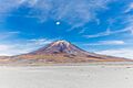
Paniri volcano in Chile.
See also
 In Spanish: Paniri para niños
- List of volcanoes in Chile
- San Pedro de Inacaliri River
- Salado River
- List of Ultras of South America
- List of andean peaks with known pre-columbian ascents
