Parole, Maryland facts for kids
Quick facts for kids
Parole, Maryland
|
|
|---|---|

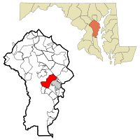
Location of Parole, Maryland
|
|
| Country | |
| State | |
| County | |
| Area | |
| • Total | 11.88 sq mi (30.77 km2) |
| • Land | 10.27 sq mi (26.60 km2) |
| • Water | 1.61 sq mi (4.18 km2) |
| Elevation | 69 ft (21 m) |
| Population
(2020)
|
|
| • Total | 17,877 |
| • Density | 1,740.87/sq mi (672.14/km2) |
| Time zone | UTC−5 (Eastern (EST)) |
| • Summer (DST) | UTC−4 (EDT) |
| FIPS code | 24-60325 |
| GNIS feature ID | 0590979 |
Parole is a community in Anne Arundel County, Maryland, in the United States. It is a suburb located right next to the city of Annapolis. Parole is known as a census-designated place (CDP). This means it is an area that looks like a town but is not officially governed as one.
In 2020, about 17,877 people lived in Parole. It is home to the Annapolis Mall, many other shopping areas, and the Anne Arundel Medical Center. Many people think of Parole as part of Annapolis, even though it is a separate community. The name "Parole" comes from its history as a camp during the American Civil War. Here, soldiers who were prisoners of war from both the Union and Confederate armies were exchanged and sent home.
Contents
Where is Parole Located?
Parole is found at coordinates 38.991657 degrees North and 76.548450 degrees West. It shares borders with several other places. To the southeast, you'll find the city of Annapolis and the community of Annapolis Neck.
Natural Borders
- To the northeast, the Severn River flows, with the community of Arnold on the other side.
- To the southwest, the South River creates another natural border. Across this river is the community of Riva.
Major Roads and Highways
Parole is an important area for transportation. U.S. Route 50 is a large highway that goes through the community. This highway has six to eight lanes and connects Parole to Washington, D.C. in the west. To the east, it leads to the Chesapeake Bay Bridge and Maryland's Eastern Shore.
Another major road, Interstate 97, meets U.S. Route 50 at the northern edge of Parole. Interstate 97 goes north towards the city of Baltimore.
Land and Water Area
The total area of Parole is about 30.6 square kilometers (11.8 square miles). Most of this area is land, which is about 26.6 square kilometers (10.3 square miles). The rest, about 4.0 square kilometers (1.5 square miles), is water. This means that about 13.20% of Parole's total area is covered by water.
Parole's Population and People
| Historical population | |||
|---|---|---|---|
| Census | Pop. | %± | |
| 2020 | 17,877 | — | |
| U.S. Decennial Census | |||
In 2020, the population of Parole was 17,877 people. This number comes from the U.S. Census. The census helps us understand how many people live in an area.
Population Density
The population density in Parole is about 672 people per square kilometer (1,741 people per square mile). This tells us how many people live in a certain amount of space.
Homes and Families
In 2000, there were 6,645 homes in Parole. About 14.1% of these homes had children under 18 living there. Many homes were made up of married couples living together. Some people lived alone, especially those who were 65 years old or older. The average number of people in a home was about 1.96.
Education in Parole
Parole is an important center for education in Anne Arundel County. The main offices for Anne Arundel County Public Schools are located here. This is where decisions are made for all the public schools in the county.
Local Schools
Two schools are also found within Parole:
- Rolling Knolls Elementary School
- Annapolis High School
Public Library Headquarters
The main headquarters for the Anne Arundel County Public Library system is also in Parole. It's important to know that this building is not a public library branch where you can check out books. Instead, it's where the library system manages its operations for all the branches in the county.
See also
 In Spanish: Parole (Maryland) para niños
 | Chris Smalls |
 | Fred Hampton |
 | Ralph Abernathy |

