
Pasayten Peak facts for kids
Quick facts for kids Pasayten Peak |
|
|---|---|

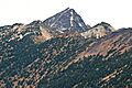
Pasayten Peak centered behind Gold Ridge.
South aspect from Slate Peak |
|
| Highest point | |
| Elevation | 7,850 ft (2,390 m) |
| Prominence | 1,650 ft (500 m) |
| Isolation | 3.02 mi (4.86 km) |
| Parent peak | Devils Peak (8,081 ft) |
| Geography | |

Pasayten Peak
Location in Washington (state)

Pasayten Peak
Location in the United States
|
|
| Location |
|
| Parent range | Okanogan Range North Cascades Cascade Range |
| Topo map | USGS Pasayten Peak |
| Type of rock | quartz diorite |
| Climbing | |
| First ascent | 1925 or 1926 by Lage Wernstedt |
| Easiest route | Scrambling class 2-3 |
Pasayten Peak is a tall mountain in Washington state. It stands about 7,850 feet (2,393 meters) high. The mountain has a unique pyramid shape at its top. You can find it in western Okanogan County.
Pasayten Peak is part of the Okanogan Range. This range is a smaller part of the larger North Cascades mountain system. The mountain is located inside the Pasayten Wilderness. This area is managed by the Okanogan National Forest.
The closest taller mountain is Wildcat Mountain, about 3 miles (4.8 km) away. Slate Peak is also nearby, about 3.7 miles (6.0 km) to the south. Pasayten Peak is the highest point on Gold Ridge. Rain and melting snow from the peak flow into the West and Middle Forks of the Pasayten River.
Mountain Weather and Climate
Most weather systems start over the Pacific Ocean. They then move northeast towards the Cascade Mountains. When these weather systems reach the North Cascades, the tall peaks force the air upwards. This process is called Orographic lift.
As the air rises, it cools and drops its moisture. This moisture falls as rain or snow onto the Cascades. Because of this, the western side of the North Cascades gets more rain and snow than the eastern side. This is especially true during the winter months.
In winter, the weather is often cloudy. But in summer, high-pressure systems over the Pacific Ocean become stronger. This usually means there are very few clouds, making for clear, sunny days.
How the Mountains Formed
The North Cascades have some of the roughest land in the Cascade Range. You can see jagged peaks, tall spires, long ridges, and deep valleys carved by glaciers. These different landforms and big changes in height happened because of geological events long ago. These events also led to the different climates we see today.
The Cascade Mountains started forming millions of years ago. This was during a time called the late Eocene Epoch. The North American Plate (a huge piece of Earth's crust) was slowly moving over the Pacific Plate. This movement caused many volcanic eruptions.
Also, small pieces of Earth's crust, called terranes, came together. These pieces were from both the ocean floor and continents. They helped create the North Cascades about 50 million years ago.
During the Pleistocene period, which was over two million years ago, glaciers played a big role. Huge sheets of ice moved forward and then melted back many times. As they moved, they scraped away the land, leaving behind rocks and debris.
The river valleys in the area have a "U" shape. This shape was created by these recent glaciers. The lifting of the land (called uplift) and cracks in the Earth's crust (called faulting) worked with glaciation. Together, these processes created the tall peaks and deep valleys of the North Cascades.
Images for kids
-
Pasayten Peak centered behind Gold Ridge. South aspect from Slate Peak
