
Slate Peak facts for kids
Quick facts for kids Slate Peak |
|
|---|---|

Slate Peak
|
|
| Highest point | |
| Elevation | 7,440 ft (2,270 m) |
| Prominence | 480 ft (150 m) |
| Geography | |

Slate Peak
Location in Washington (state)

Slate Peak
Location in the United States
|
|
| Location |
|
| Parent range | Okanogan Range North Cascades Cascade Range |
| Topo map | USGS Slate Peak |
| Climbing | |
| Easiest route | Walking |
Slate Peak is a mountain in Washington state. It stands about 7,440 feet (2,268 meters) tall. This peak is located on the border between Okanogan County and Whatcom County.
Slate Peak is part of the Okanogan Range. This range is a smaller part of the larger North Cascades mountains. The mountain is about 15 miles (24 km) northwest of Mazama. It sits on the edge of the Pasayten Wilderness. The land around it is managed by the Okanogan National Forest.
Slate Peak is special because it has the highest road in Washington. It also has the highest fire lookout tower. The road goes almost to the very top of the mountain. However, the Forest Service has closed the last part of the road to cars. This means you need to walk the final few hundred yards to reach the summit.
Two famous trails pass by Slate Peak. The Pacific Crest Trail goes along the west side of the peak. The West Fork Pasayten Trail follows the eastern slope. Water from Slate Peak flows in two directions. Some water goes east into the Pasayten River. Other water flows west into Slate Creek, which joins the Skagit River.
Contents
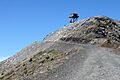
Slate Peak Fire Lookout: A Historic Viewpoint

A fire lookout tower helps spot wildfires from high places. The first lookout tower on Slate Peak was built in 1924. It had a special roof shape called a gable roof.
In 1956, the Air Force changed the top of the mountain. They removed about 40 feet (12 meters) from the peak. They also took down the old lookout tower. This was to make space for a radar station, but it was never built.
The lookout tower you see today is 41 feet (12 meters) tall. It is kept ready for emergency use. The Slate Peak Lookout was added to the National Historic Lookout Register in 2000. This means it is an important historical site.
On a clear day, you can see many other mountains from the tower. These include Silver Star Mountain, The Needles, and Jack Mountain. It's a great place for amazing views!
Weather at Slate Peak: Understanding the Climate

Most of the weather in this area comes from the Pacific Ocean. These weather systems move northeast towards the Cascade Mountains. When they reach the North Cascades, the mountains force the air to rise. As the air goes higher, it cools down and drops its moisture. This causes rain or snow to fall on the mountains. This process is called Orographic lift.
Because of this, the west side of the North Cascades gets more rain and snow. This is especially true during the winter months. Winters are usually cloudy. However, in summer, high pressure systems over the Pacific Ocean often bring clear skies.
The best time to visit Slate Peak is from July through September. The weather is usually good then, and the road to the peak is open. Sometimes, smoke from distant wildfires can make it harder to see. Smoky summers have become more common due to climate change.
Geology of the North Cascades: How Mountains Are Formed
The North Cascades mountains have a very rugged landscape. You can see sharp peaks, tall spires, long ridges, and deep valleys carved by glaciers. These different shapes and big changes in elevation were created by geological events over millions of years. These events also led to the different climates in the Cascade Range.
The Cascade Mountains started forming millions of years ago. This was during a time called the late Eocene Epoch. The North American Plate was moving over the Pacific Plate. This movement caused a lot of volcanic activity. Also, small pieces of the Earth's crust, called terranes, came together. These pieces helped form the North Cascades about 50 million years ago.

During the Pleistocene period, which was over two million years ago, glaciers played a big role. Huge sheets of ice moved across the land many times. As they moved, they scraped away rock and left behind debris. The river valleys in this area have a "U" shape. This shape was created by these recent glaciers.
The tall peaks and deep valleys of the North Cascades were formed by two main processes. One is uplift, which means the land was pushed upwards. The other is faulting, where cracks in the Earth's crust cause sections to move. These processes, combined with the action of glaciers, created the amazing landscape we see today.
Images for kids
-
Slate Peak
