Patterson, California facts for kids
Quick facts for kids
Patterson
|
|
|---|---|
| City of Patterson | |
| Nickname(s):
Apricot Capital of the World
|
|

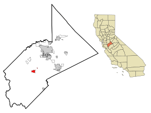
Location in Stanislaus County and the state of California
|
|
| Country | United States |
| State | California |
| County | Stanislaus |
| Region | Central Valley |
| CSA | San Jose-San Francisco-Oakland |
| Metro | Modesto |
| Incorporated | December 22, 1919 |
| Government | |
| • Type | Mayor–council |
| • Body | Patterson City Council |
| Area | |
| • City | 7.873 sq mi (20.39 km2) |
| • Land | 7.787 sq mi (20.17 km2) |
| • Water | 0.086 sq mi (0.22 km2) |
| Elevation | 115 ft (35 m) |
| Highest elevation | 171 ft (52 m) |
| Lowest elevation | 102 ft (31 m) |
| Population
(2020)
|
|
| • City | 23,781 |
| • Rank | 6th in Stanislaus County |
| • Density | 3,020.58/sq mi (1,166.25/km2) |
| • Metro | 550,081 (102nd) |
| • CSA | 9,665,000 (5th) |
| Demonym(s) | Pattersonite |
| Time zone | UTC−08:00 (Pacific Time Zone) |
| • Summer (DST) | UTC−07:00 (Pacific Daylight Time) |
| ZIP Code |
95363
|
| Area code | 209 |
| FIPS code | 06-56112 |
| GNIS feature IDs | 277574, 2411383 |
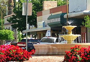
Patterson is a city in Stanislaus County, California, United States. It is located near Interstate 5. Patterson is about 27 miles (43 km) southeast of Tracy. It is also part of the Modesto Metropolitan Statistical Area. Patterson is famous for being the "Apricot Capital of the World." The city celebrates this with an annual Apricot Fiesta. This festival features many apricot-themed foods, drinks, desserts, and games. In 2010, the city had a population of 20,413 people.
Contents
History of Patterson, California
Early Land Ownership
The area where Patterson is today was once part of a large Mexican land grant called Rancho Del Puerto. This grant was given to Mariano and Pedro Hernandez in 1844. The land stretched from what is now Highway 33 to the San Joaquin River. Its northern border was Del Puerto Creek.
Later, in 1855, Samuel G. Reed and Ruben S. Wade claimed this land. President Abraham Lincoln signed the official document giving them ownership in 1864. They owned about 13,340 acres (54 km2) of land.
John D. Patterson's Vision
Reed and Wade sold the land to J. O. Eldredge in 1866. Just two months later, Eldredge sold it to John D. Patterson for $5,400. John D. Patterson bought even more land over time. When he passed away in 1902, he owned about 18,462 acres (75 km2).
His heirs then sold the land to the Patterson Ranch Company in 1908. Thomas W. Patterson, one of the executors, had a special plan for the town. He wanted Patterson to be unique. He designed the town using circles and streets that spread out from the center. This design was inspired by cities like Washington, D.C. and Paris, France. He also had palm, eucalyptus, and sycamore trees planted along the main streets.
Becoming a City
The map for the Patterson Colony was officially recorded in 1909. Soon after, people started buying land and city lots. Patterson became an official city on December 22, 1919. It was the third city in Stanislaus County to do so. In 1971, Patterson officially became known as the "Apricot Capital of the World."
Geography and Location
Patterson is located at 37°28′23″N 121°7′58″W / 37.47306°N 121.13278°W. The city covers a total area of about 6.0 square miles (16 km2), and all of it is land.
Patterson is about 17 miles (27 km) southwest of Modesto. It is also about 78 miles (126 km) southeast of Oakland.
Population and People
| Historical population | |||
|---|---|---|---|
| Census | Pop. | %± | |
| 1920 | 694 | — | |
| 1930 | 905 | 30.4% | |
| 1940 | 1,109 | 22.5% | |
| 1950 | 1,343 | 21.1% | |
| 1960 | 2,246 | 67.2% | |
| 1970 | 3,147 | 40.1% | |
| 1980 | 3,908 | 24.2% | |
| 1990 | 8,626 | 120.7% | |
| 2000 | 11,606 | 34.5% | |
| 2010 | 20,413 | 75.9% | |
| 2020 | 23,781 | 16.5% | |
| U.S. Decennial Census | |||
In 2010, the population of Patterson was 20,413 people. Almost all of these people lived in homes. The city's population has grown a lot over the years. For example, in 1920, there were only 694 people living in Patterson. By 2020, the population had grown to 23,781.
Culture and Celebrations
Local Media
Patterson has its own newspaper called the Patterson Irrigator. It started in 1911 and has been in the same downtown location since 1929. The Irrigator is now published once a week.
The city is also home to two radio stations. One is KOSO, which plays country music. The other is KTSE-FM, which plays Spanish contemporary hit music.
Annual Celebrations
Patterson hosts its biggest event of the year, the Apricot Fiesta, during the first weekend of June. The fiesta starts on Friday with beauty pageants. The Patterson Library holds an art show, and the Patterson Museum shows local history exhibits. The museum is also known as the Center Building.
The three-day celebration also includes exciting fireworks shows. In the mornings, you can see hot air balloons taking off from the football stadium at Patterson High School.
Another important celebration is the Fiestas Patrias. This event takes place in mid-September. It celebrates the independence of various Latin American countries.
Education in Patterson
The Patterson Joint Unified School District serves many students in the area. It has more than 5,669 students. The district operates four elementary schools, one middle school, and two high schools.
Transportation in Patterson
Major roads that pass through Patterson include Interstate 5 and State Route 33. These highways help people travel to and from the city.
Patterson also has public transportation. The Stanislaus Regional Transit Authority provides bus services. This includes commuter service to the Dublin/Pleasanton station.
Notable People from Patterson
- Amy Franceschini, artist
- Eslabon Armado, band
- Pedro Tovar, singer
See also
 In Spanish: Patterson (California) para niños


