
Perryton, Texas facts for kids
Quick facts for kids
Perryton, Texas
|
|
|---|---|

Welcome Sign (2010)
|
|
| Nickname(s):
"Wheatheart of the Nation"
|
|

Location of Perryton within Texas
|
|
| Country | United States |
| State | Texas |
| County | Ochiltree |
| Founded | 1919 |
| Named for | George Perry |
| Area | |
| • Total | 4.80 sq mi (12.43 km2) |
| • Land | 4.80 sq mi (12.43 km2) |
| • Water | 0.00 sq mi (0.00 km2) |
| Elevation | 2,927 ft (892 m) |
| Population
(2020)
|
|
| • Total | 8,492 |
| • Density | 1,769.2/sq mi (683.19/km2) |
| Time zone | UTC-6 |
| • Summer (DST) | UTC-5 (CDT) |
| ZIP code |
79070
|
| Area code | 806 |
| FIPS code | 48-56912 |
| GNIS ID | 2411406 |
Perryton is a city in Texas, USA. It's the main town, or county seat, of Ochiltree County, Texas. In 2020, about 8,492 people lived there. You can find Perryton just a short distance south of the Texas and Oklahoma border.
Contents
History of Perryton
Perryton started in the late 1910s. Two towns, Ochiltree and Gray, decided to move and join together. This happened because a new railroad was built between them. The new combined community was named Perryton. It was named after George M. Perry, who was an early judge in the county.
June 2023 Tornado Impact
On the evening of June 15, 2023, a strong tornado hit northern Perryton. This tornado was rated as an EF3, which means it was very powerful. It moved southeast, destroying many mobile homes. It also damaged buildings in the downtown area. The tornado knocked down cell towers and other communication towers. One mobile home caught fire, and the fire spread to many other homes nearby. Sadly, three people died, and over 100 people were hurt after the tornado struck the town.
Geography and Climate
Perryton covers about 4.5 square miles (12 square kilometers) of land. Only a tiny part of this area is covered by water.
Perryton's Weather Patterns
Perryton has a cool semiarid climate. This means it's usually dry, but not a desert. Winters can be very cold, especially in the mornings. Temperatures often drop below freezing. Sometimes, very cold air from the Yukon can make it even colder. However, warm winds called chinook winds from the Rocky Mountains can also make winter days surprisingly warm. For example, on one day in February 2017, the temperature rose from 25°F (-4°C) in the morning to 92°F (33°C) in the afternoon!
Summers in Perryton are hot. The mornings stay fairly mild. Many afternoons reach 90°F (32°C) or higher. Some days can even get above 100°F (38°C). The hottest day ever recorded was 113°F (45°C) in June 2011. The coldest morning ever was -17°F (-27°C) in January 1988.
| Climate data for Perryton, Texas, 1991–2020 normals, extremes 1965–2022 | |||||||||||||
|---|---|---|---|---|---|---|---|---|---|---|---|---|---|
| Month | Jan | Feb | Mar | Apr | May | Jun | Jul | Aug | Sep | Oct | Nov | Dec | Year |
| Record high °F (°C) | 81 (27) |
92 (33) |
96 (36) |
101 (38) |
106 (41) |
113 (45) |
112 (44) |
109 (43) |
106 (41) |
102 (39) |
92 (33) |
81 (27) |
113 (45) |
| Mean maximum °F (°C) | 70.3 (21.3) |
76.7 (24.8) |
85.0 (29.4) |
90.0 (32.2) |
95.6 (35.3) |
100.6 (38.1) |
103.3 (39.6) |
100.8 (38.2) |
97.6 (36.4) |
90.7 (32.6) |
79.2 (26.2) |
70.7 (21.5) |
105.3 (40.7) |
| Mean daily maximum °F (°C) | 50.9 (10.5) |
55.0 (12.8) |
64.5 (18.1) |
72.7 (22.6) |
81.5 (27.5) |
91.0 (32.8) |
95.5 (35.3) |
93.2 (34.0) |
86.6 (30.3) |
74.1 (23.4) |
62.2 (16.8) |
50.8 (10.4) |
73.2 (22.9) |
| Daily mean °F (°C) | 37.2 (2.9) |
40.4 (4.7) |
49.1 (9.5) |
57.5 (14.2) |
67.2 (19.6) |
77.5 (25.3) |
82.0 (27.8) |
80.0 (26.7) |
72.8 (22.7) |
60.0 (15.6) |
47.7 (8.7) |
38.1 (3.4) |
59.1 (15.1) |
| Mean daily minimum °F (°C) | 23.5 (−4.7) |
25.9 (−3.4) |
33.8 (1.0) |
42.3 (5.7) |
53.0 (11.7) |
63.9 (17.7) |
68.4 (20.2) |
66.8 (19.3) |
58.9 (14.9) |
45.8 (7.7) |
33.2 (0.7) |
25.4 (−3.7) |
45.1 (7.3) |
| Mean minimum °F (°C) | 5.7 (−14.6) |
8.4 (−13.1) |
13.7 (−10.2) |
24.3 (−4.3) |
35.4 (1.9) |
49.5 (9.7) |
56.9 (13.8) |
55.3 (12.9) |
41.0 (5.0) |
27.4 (−2.6) |
14.1 (−9.9) |
6.6 (−14.1) |
−0.3 (−17.9) |
| Record low °F (°C) | −17 (−27) |
−15 (−26) |
−5 (−21) |
13 (−11) |
23 (−5) |
37 (3) |
47 (8) |
46 (8) |
29 (−2) |
11 (−12) |
−4 (−20) |
−12 (−24) |
−17 (−27) |
| Average precipitation inches (mm) | 0.69 (18) |
0.58 (15) |
1.51 (38) |
1.90 (48) |
2.80 (71) |
3.20 (81) |
3.48 (88) |
2.96 (75) |
1.86 (47) |
2.04 (52) |
0.83 (21) |
0.97 (25) |
22.82 (579) |
| Average snowfall inches (cm) | 3.1 (7.9) |
2.4 (6.1) |
2.7 (6.9) |
0.6 (1.5) |
0.0 (0.0) |
0.0 (0.0) |
0.0 (0.0) |
0.0 (0.0) |
0.0 (0.0) |
0.8 (2.0) |
1.1 (2.8) |
2.9 (7.4) |
13.6 (34.6) |
| Average precipitation days (≥ 0.01 in) | 2.5 | 3.0 | 4.9 | 5.7 | 6.8 | 7.3 | 6.7 | 6.8 | 5.0 | 5.0 | 3.5 | 3.2 | 60.4 |
| Average snowy days (≥ 0.1 in) | 1.3 | 1.2 | 1.0 | 0.2 | 0.0 | 0.0 | 0.0 | 0.0 | 0.0 | 0.3 | 0.6 | 1.2 | 5.8 |
| Source 1: NOAA | |||||||||||||
| Source 2: XMACIS2 | |||||||||||||
Population Changes in Perryton
| Historical population | |||
|---|---|---|---|
| Census | Pop. | %± | |
| 1930 | 2,824 | — | |
| 1940 | 2,325 | −17.7% | |
| 1950 | 4,417 | 90.0% | |
| 1960 | 7,903 | 78.9% | |
| 1970 | 7,810 | −1.2% | |
| 1980 | 7,991 | 2.3% | |
| 1990 | 7,607 | −4.8% | |
| 2000 | 7,774 | 2.2% | |
| 2010 | 8,802 | 13.2% | |
| 2020 | 8,492 | −3.5% | |
| U.S. Decennial Census | |||
The population of Perryton has changed over the years. In 1930, about 2,824 people lived there. By 2020, the population had grown to 8,492 people.
Who Lives in Perryton?
As of the 2020 census, there were 8,492 people living in Perryton. These people made up 2,869 households, with 2,161 of them being families.
| Race | Number | Percentage |
|---|---|---|
| White (NH) | 3,247 | 38.24% |
| Black or African American (NH) | 12 | 0.14% |
| Native American or Alaska Native (NH) | 31 | 0.37% |
| Asian (NH) | 24 | 0.28% |
| Pacific Islander (NH) | 2 | 0.02% |
| Some Other Race (NH) | 19 | 0.22% |
| Mixed/Multi-Racial (NH) | 155 | 1.83% |
| Hispanic or Latino | 5,002 | 58.9% |
| Total | 8,492 |
Education and Schools

Students in Perryton and the nearby countryside attend schools in the Perryton Independent School District. The main high school for the area is Perryton High School.
Transportation in Perryton
Perryton is easy to reach by road. It is located where two important roads meet: U.S. Route 83 and Texas State Highway 15.
Famous People from Perryton
Many interesting people have come from Perryton, including:
- Caleb Campbell, an NFL football player.
- Jeremy Campbell, a Paralympic gold medalist in sports like Pentathlon and Discus. He won medals in 2008, 2012, 2020, and 2024.
- Ryan Culwell, a singer and songwriter.
- John Erickson, the author who created the popular Hank the Cowdog book series.
- Keith Flowers, another NFL football player.
- Mickey Gates, who was a member of the Arkansas House of Representatives.
- Mike Hargrove, a former MLB baseball player and manager.
Images for kids
-
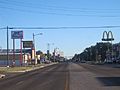
U.S. Highway 83 as it proceeds through downtown (2010)
-
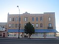
Former Hotel Perryton in downtown (2010)
-

Ellis Theater in downtown (2010)


See also
 In Spanish: Perryton (Texas) para niños
