
Pinnacle Peak (King County, Washington) facts for kids
Quick facts for kids Pinnacle Peak |
|
|---|---|

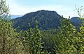
Pinnacle Peak seen from the north
|
|
| Highest point | |
| Elevation | 1,801 ft (549 m) |
| Prominence | 981 ft (299 m) |
| Isolation | 3.39 mi (5.46 km) |
| Parent peak | Radio Hill (1,950 ft) |
| Geography | |

Pinnacle Peak
Location in Washington (state)

Pinnacle Peak
Location in the United States
|
|
| Country | United States |
| State | Washington |
| County | King |
| Parent range | Cascade Range |
| Topo map | USGS Enumclaw |
| Type of rock | Basalt |
| Climbing | |
| Easiest route | Hiking trail |
Pinnacle Peak, also known as Mount Peak, is a cool mountain in King County, Washington. It stands 1,801 feet (about 549 meters) tall and is covered in forests. This peak is part of the Cascade Range, located on its western edge. You can find it just south of Enumclaw, Washington and about 25 miles northwest of the famous Mount Rainier. Did you know there are two other mountains in Washington with the same name? One is in the Tatoosh Range near Mount Rainier, and another is in North Cascades National Park.
Contents
The Story of Pinnacle Peak's Name
Pinnacle Peak has an interesting history behind its name! It was first called Mount Pete. This name honored Pete Chorak, one of the early settlers in Enumclaw. Over time, people misheard "Pete" as "Peak." So, the name Mount Peak became popular for a while.
Later, a fire lookout tower was built on the summit. This lookout was named the Pinnacle Peak Lookout. That's how the name Pinnacle Peak eventually became the most common name for the mountain.
There's also a special trail on the north side of the peak. It's called the Cal Magnusson Trail. This trail is named after Cal Magnusson, a well-known mountaineer from the Cascade Mountains. He worked at REI for 25 years alongside the famous American mountain climber Jim Whittaker.
Weather Around the Peak
Pinnacle Peak is in a place with a "marine west coast" climate. This means it gets a lot of moisture from the Pacific Ocean. Imagine big weather fronts (like giant air masses) moving from the Pacific Ocean towards the Cascade Mountains.
When these fronts hit the tall Cascade peaks, the mountains push the air upwards. This process is called orographic lift. As the air rises, it cools down and drops its moisture. This causes a lot of rain or snow to fall on the western side of the Cascades, especially in winter.
So, winters here are often cloudy and snowy. But in summer, high-pressure systems over the Pacific Ocean bring clearer skies. This means you'll often find sunny days with few clouds during the summer months. Any rain or snow that falls on Pinnacle Peak eventually flows into the White River, which runs along the south base of the peak.
How Pinnacle Peak Was Formed
Pinnacle Peak is actually an extinct volcanic cinder cone. This means it's a type of volcano that erupted long ago and is now inactive. It rises about 1,000 feet from the flat farmlands around Enumclaw.
This flat land was created by something called the Osceola Mudflow. About 5,600 years ago, a huge mudflow spread out from nearby Mount Rainier. This mudflow was so big that it even buried parts of Pinnacle Peak! This tells us that Pinnacle Peak is older than that massive mudflow.
As you hike the trails near the top, you might spot some cool rock formations. These are called columnar basalt. They look like tall, many-sided columns of rock that formed when lava cooled slowly.
Exploring Pinnacle Peak Park
Pinnacle Peak is part of a beautiful area called Pinnacle Peak Park. The park covers 334 acres, with the peak itself taking up 256 acres. It's a great place for hiking and enjoying nature!
There are two main trails to explore. On the north side, you'll find the one-mile Cal Magnusson Trail. It's quite steep and winds through a dense forest.
The south slope trail offers a different experience. It has more parking and a gentler climb. This trail follows a gravel road and path, giving you some amazing views. You can look south towards the majestic Mount Rainier and west towards Buckley, Washington.
On a busy weekend, hundreds of people visit these trails every day. It's a very popular spot for local hikers. Many people also use it to train for bigger climbs, like Mount Rainier. The very top of Pinnacle Peak is covered with trees, so there aren't wide-open views from the summit itself. However, you can still see the concrete foundations of the old fire lookout tower and a special marker from the USGS. There are plans to rebuild the lookout, which would bring back those amazing views from the top!
Gallery
-
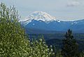
Mount Rainier seen from south side trail
-
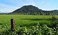
Pinnacle Peak
-
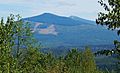
Buckley seen from south side trail
-
The Three Sisters seen from trail
-
Long Hill seen from south side trail


