Piñon Canyon Maneuver Site facts for kids
The Piñon Canyon Maneuver Site (you might also see it spelled Pinon or Pinyon) is a huge U.S. Army base in southeastern Colorado. It covers about 235,896 acres, which is like 955 square kilometers! This site is a special training area for soldiers from Fort Carson. For a long time, the Army wanted to make the site even bigger. However, many local people and groups who care about nature were against this idea.
Contents
Where is Piñon Canyon?
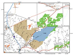
The Piñon Canyon Maneuver Site (PCMS) is located in Las Animas County, Colorado, just northeast of Trinidad, Colorado. It shares a border with the Comanche National Grassland to its north. The Purgatoire River, which locals call the Picketwire, forms its eastern edge.
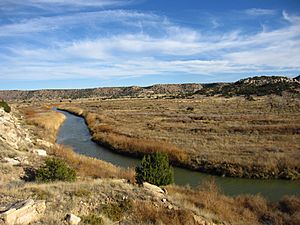
The land here is between 4,300 and 5,800 feet high. It has a dry, steppe climate, meaning it doesn't get much rain. Usually, it gets about 12 to 16 inches of rain each year. The ground is mostly flat or gently rolling, with small, rocky hills and flat-topped mountains called mesas. The Purgatoire River flows through a deep canyon, about 300 to 400 feet deep. Smaller streams have carved steep ditches called arroyos into the land. Most of the plants are short grasses, mixed with pinyon and juniper trees.
Before the Army bought this land, it was mostly used for ranching and raising animals. Not many people lived there. An old path of the Santa Fe Trail runs close to the PCMS. You can also find ancient rock art and petroglyphs made by Native Americans in the rocky canyons. Large animals like Pronghorn, Elk, and Mule Deer live in this area.
Why was the Site Created?
The Army bought the land for PCMS in 1983. They used a process called Eminent domain to get almost half of the land. This means the government can buy private land for public use, even if the owners don't want to sell.
The main reason for PCMS is to give soldiers from Fort Carson and other military bases a place to practice large-scale movements. PCMS and Fort Carson together are one of the biggest training areas for military movements in the United States. Only Fort Irwin, California is larger. The Army says PCMS can handle many types of training, including large exercises where many soldiers and vehicles practice together.
What Facilities are at PCMS?
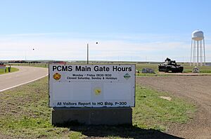
The site has a main area for soldiers, a place to load and unload trains, helicopter landing pads, and an airstrip. PCMS holds two big military exercises each year. During these exercises, about 5,000 soldiers, 300 heavy tracked vehicles (like tanks), and 400 wheeled vehicles use the vast wilderness. These exercises are intense and can last for a month.
Protecting the Environment
The Army has said that a special part of PCMS is how much they focus on protecting the environment. The grassland here is delicate. You can still see the tracks from wagons that traveled the Santa Fe Trail more than 130 years ago!
In 1988, the National Wildlife Federation praised PCMS for its great work in managing natural resources. In 1991, the Army gave 16,000 acres of land in the Purgatoire River Canyon to the Comanche National Grassland. This was done to help preserve the area and allow for recreation. In 2002, the Army also worked with The Nature Conservancy to set up Conservation easements around the site. These are agreements that protect the land from development.
Since the Army bought the land, cattle no longer graze there. Because of this, the herds of Elk and Antelope have grown. The antelope herd, for example, now has more than 1,300 animals. One civilian worker at PCMS said that the land is "neither better nor worse, just different." They explained that "we've traded cattle trails for tank trails and Humvee trails."
Plans to Expand the Site
In 2003, the Army announced a plan to expand PCMS by a huge amount: 6.9 million acres. This land belonged to private citizens and the Comanche National Grassland in southeastern Colorado. The goal was to allow even bigger military training operations. If this plan had gone through, PCMS would have been three times larger than any other military base in the U.S. It would have been bigger than the states of Maryland and Massachusetts combined! The Army thought about 17,000 local residents would have to sell their land and move. Also, the Comanche National Grassland, which is over 400,000 acres, would have become part of the expanded PCMS.
Later studies still said the Army needed more land for PCMS. A report in 2005 even suggested that people in Southeast Colorado would be more open to the expansion because of a strong pro-military feeling. However, this turned out to be wrong.
When people learned about the expansion plans, two groups were formed to fight it: The Pinyon Canyon Expansion Opposition Coalition and Not 1 More Acre. They called the plan "one colossal land grab." Ranchers and local citizens started these groups because they wanted to protect their private property and the traditional ranching way of life.
Over time, because of this strong opposition, the Army's expansion plans became smaller. In 2007, the Army suggested buying only 418,000 acres, and only from "willing sellers." This meant they would not use eminent domain. But the opposition groups believed this was just the first step in a bigger plan to take over most of southeastern Colorado. They also said the Army couldn't be trusted because it had broken promises in the past. For example, they claimed the Army had promised PCMS would never expand, that it would help the local economy, and that live fire would never be used. (Live fire exercises actually started at PCMS in 2004.)
The groups against the expansion also criticized some environmental organizations. They thought these groups were working with the Army. The Army's plan included creating an 80,000-acre conservation zone along the Purgatoire River, to be managed by the Nature Conservancy. The Army's plan even stated that one reason for this zone was to "get support from eco-groups" for the expansion. The Nature Conservancy, however, said they were not cooperating with the Army on the expansion.
The opposition groups successfully got support from Colorado politicians and communities. From 2007 to 2010, Congress even banned funding for the PCMS expansion each year. However, in November 2010, the Air Force announced a plan for a low-altitude training range. This range would cover most of southern Colorado and northern New Mexico. To the people against the PCMS expansion, this seemed like a new way for the military to try and "militarize the land and air of Southern Colorado."
In December 2010, the Army suggested that local governments sign a "community covenant." This was meant to build better relationships and ensure local communities got more economic benefits from PCMS. The opposition groups were against signing this "covenant." They said the first step to improving relations was for the Army to cancel expansion plans and stop using soldiers' service as a way to boost the economy.
In September 2011, officials from Fort Carson talked about changing the name of PCMS to "Fort Carson South." This idea was also criticized by those against the expansion.
Expansion Plans Cancelled
Finally, on November 25, 2013, the U.S. Army announced that its plan to expand the Piñon Canyon Maneuver Site had been cancelled.
Images for kids
-
Piñon Canyon trail ride illustrating the character of the country proposed for inclusion in the expanded PCMS. https://www.youtube.com/watch?v=Jp0sE3aBuoE
-
Piñon Canyon Expansion Presentation, part one https://www.youtube.com/watch?v=FKlyHtVwg28
-
Piñon Canyon Expansion Presentation, part two https://www.youtube.com/watch?v=auWhj4y7V5o
 | Valerie Thomas |
 | Frederick McKinley Jones |
 | George Edward Alcorn Jr. |
 | Thomas Mensah |


