Point Lookout Foreshore facts for kids
Quick facts for kids Point Lookout Foreshore |
|
|---|---|

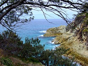
View of the gorge, Point Lookout Foreshore, 2008
|
|
| Location | East Coast Road, Point Lookout, City of Redland, Queensland, Australia |
| Official name: Point Lookout Foreshore, Mooloomba | |
| Type | state heritage (landscape) |
| Designated | 27 August 2004 |
| Reference no. | 602261 |
| Significant period | 1770, 1803, 1902, 1932 (historical) |
| Lua error in Module:Location_map at line 420: attempt to index field 'wikibase' (a nil value). | |
Point Lookout Foreshore is a special heritage-listed area. It is a rocky headland on the north-eastern tip of Stradbroke Island in Queensland, Australia. People also know it as Mooloomba. This beautiful spot was added to the Queensland Heritage Register on 27 August 2004.
Contents
A Look Back in Time
Early Days and European Exploration
In 1770, Captain James Cook named this rocky headland "Point Lookout." He saw it as a warning for ships. For thousands of years before, Indigenous people lived and used this area.
The first recorded European visit was in 1803. Matthew Flinders sent his crew ashore at what is now Cylinder Beach. They collected water from a spring there.
Point Lookout's Isolation
For a long time, Point Lookout stayed isolated. Even though it was close to Brisbane, few people visited. The first European settlements on Stradbroke Island were in easier-to-reach places. These spots had safe anchorages for boats.
A pilot station was set up at Amity Point in 1825. A storage depot for the penal settlement at Moreton Bay was built at Dunwich in 1827. However, this depot was soon abandoned.
Early Land Use
In 1846, a survey of the coast included Point Lookout. It was marked as a government reserve for future use. But development continued in other parts of Stradbroke Island. For example, a quarantine station opened at Dunwich in 1850. Later, a large government hospital called the Dunwich Benevolent Asylum was built there in 1864.
In 1895, Bill North got permission to run cattle around Point Lookout. He built a hut and a cattle dip near Adder Rock. He used the land for years, supplying meat to the asylum at Dunwich.
The Shipwreck of the Prosperity
In 1902, a ship called the Prosperity was wrecked near Point Lookout. Bill North helped five surviving crew members. Sadly, two crew members died. They were buried behind the dunes on what is now called Deadman's Beach.
Becoming a Holiday Spot
For a long time, Stradbroke Island was used for institutions. This meant people from Brisbane did not see it as a holiday place. Amity Point became a small holiday resort. But it was separate from Dunwich. The only way to travel between them was by walking along the beach at low tide.
Point Lookout started to become a settlement in 1932. A strong concrete lighthouse was built there. A hut was also built at Cylinder Beach to store acetylene cylinders. This is how Cylinder Beach got its name!
Soon after the lighthouse, Bertie Clayton opened a guesthouse above Main Beach. Guests arrived by boat at Amity Point. Bertie would pick them up by car. They would travel along the beach or a track to the guesthouse. His guests stayed in tents with timber floors. These later became small huts.
Protecting the Foreshore
The government surveyed and sold land around Point Lookout. Most of the land sold was away from the foreshores. The beautiful wilderness areas were protected. They became a Reserve for Camping and Recreation.
In 1935, Hayles Cruises started a regular boat service from Brisbane to Amity Point. This made it easier for campers and visitors to reach Point Lookout. It encouraged more people to settle there, even if just for weekends.
Growth stopped during World War II. American and Australian forces used the area. Civilians were not allowed to visit.
After the War and Easier Access
After the war, Point Lookout became a holiday spot again. It was still hard to get to. It took a three-hour boat trip from Brisbane. Then, a bus trip over a rough track from Amity Point. Building houses was tough because all materials came the same way.
By 1948, about 40 people lived there permanently. There were also holidaymakers and guests at the Samarinda Guest House. This was the new name for Clayton's Guest House.
In 1947, the Dunwich Benevolent Institution closed. This opened up more of the island for settlement. In 1955, Stradbroke Island became part of the Redland Shire. Soon after, a rough road was built. It connected Dunwich, Amity Point, and Point Lookout.
In 1957, a barge service started from Redland Bay to Dunwich. This allowed cars to regularly access the island.
Modern Day Point Lookout
With easier access, Point Lookout became very popular. Many articles about it appeared in newspapers. More land was sold in the 1970s and 1980s for holiday homes. The area has grown steadily since then. Most new buildings are small homes.
The Reserve for Camping and Recreation has mostly stayed the same. Some land was used for new homes in the 1970s. You can now see some buildings from the beaches.
Today, Point Lookout headland is a great place for whale watching. You can also watch sea birds flying by. It is a popular spot to see fish, turtles, porpoises, and sharks. The headland overlooking Frenchman's Beach offers excellent views of the ocean.
Exploring Point Lookout's Beauty
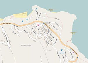
The Point Lookout reserve is a large area of natural bushland. It sits between the main East Coast Road and the ocean. It includes the rocky headland and three small beaches. These beaches are surrounded by rocky headlands and steep, tree-covered hills.
All three beaches – Frenchman's, Deadman's, and Cylinder Beach – are incredibly scenic. They look amazing from above and from the beach itself.
Frenchman's Beach
Frenchman's Beach is especially beautiful. It feels natural and untouched. You can't see much development from the beach. A timber staircase leads from the main road down to the beach. It gives you great views of the beach and the coastal plants. The plants are thick and grow up the high dunes to the road.
Cylinder Beach
Cylinder Beach is shaped like a crescent moon. It lies between rocky headlands. Natural plants grow behind the beach and on the headlands. Some plants were removed in the past for parking and camping. But enough remain to hide the buildings on the hills behind the beach. The plants on Cylinder Headland are very thick. They hide a church and other buildings.
Cylinder Beach faces north. It is the most popular swimming beach at Point Lookout. The beach often has a shallow lagoon. This is a great place for children to swim. Cylinder Headland is a good spot to watch surfers and swimmers. You can also see Shag Rocks and Moreton Island in the distance.
Deadman's Beach
Deadman's Beach is between Frenchman's and Cylinder Beaches. It is also surrounded by rocky headlands. You can see some houses from the beach. They are above the rocky cliffs and trees at the northern edge. The rest of the beach has a thick background of natural plants.
The southern end of the beach has many rocky outcrops. These contain lots of rock pools. The area behind this part of the beach has high dunes and a rocky cliff. This cliff is called Camel Rock. It is made of volcanic rock that is very fractured. Where the cliffs meet Frenchman's Beach, they have worn away to form a cave. Most of the high dunes are covered in plants. But one large dune is bare sand. It is a popular play area for children.
The Main Headland
South of these beaches is a large headland. This is the main natural feature of Point Lookout. It has high volcanic cliffs that stick out into the ocean. They form narrow gorges with steep sides. There are also rock shelves and rocky inlets. The two main inlets are North and South Gorge.
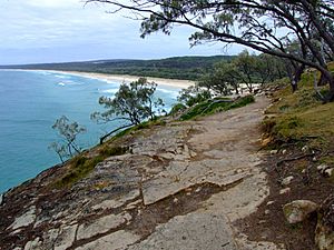
You can enjoy amazing views from a walking track on top of the cliffs. The track starts above South Gorge. You can see the Gorge and its swimming beach. You can also see Main Beach and Eighteen Mile Swamp to the south. Further east, the track offers wide views of the ocean. You can also see Whale Rock with its blowhole.
The track goes around North Gorge. Here, you can see waves breaking on rocks. You can also see the narrow sandy inlet at the bottom of the Gorge. The path then climbs to the headland overlooking Frenchman's Beach. Finally, it leads back to the main East Coast Road. The whole walk is about one kilometre long.
Plants of the Headland
The headland is mostly covered by native Casuarina and Pandanus trees. Banksia and Brush Box trees grow on the hillsides. They also grow in more protected parts of the Reserve headland. Over time, some original smaller plants have been replaced by garden plants. But on the Point Lookout headland, most of the grass and some native shrubs remain.
Why Point Lookout Foreshore is Special
Point Lookout Foreshore was added to the Queensland Heritage Register on 27 August 2004. It is important for several reasons:
- It shows how Queensland's history has changed. The cliffs and sea caves at Point Lookout are rare. They help us understand the geology of Queensland.
- It is incredibly beautiful. The foreshore has amazing natural beauty. It offers many different land and sea views. You can see beaches, rocky headlands, gorges, and rocks. There are also different types of plants and rugged rocky edges. It is a very diverse and beautiful area with wide views of the ocean.
- It is important to the local community. The Indigenous community of North Stradbroke Island values the Point Lookout foreshore. It is important to them for social, cultural, and spiritual reasons. It is also a cherished holiday spot for both island residents and regular visitors.
 | May Edward Chinn |
 | Rebecca Cole |
 | Alexa Canady |
 | Dorothy Lavinia Brown |


