Port Republic, New Jersey facts for kids
Quick facts for kids
Port Republic, New Jersey
|
||
|---|---|---|
|
City
|
||
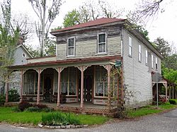
Amanda Blake Store
|
||
|
||
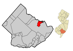
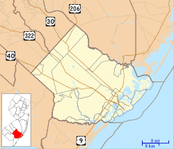
Map of Port Republic in Atlantic County. Inset: Location of Atlantic County in the State of New Jersey.
|
||
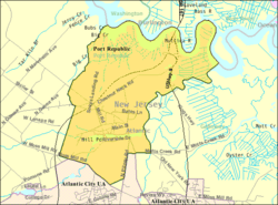
Census Bureau map of Port Republic, New Jersey
|
||
| Country | ||
| State | ||
| County | Atlantic | |
| Incorporated | March 1, 1905 | |
| Government | ||
| • Type | City | |
| • Body | City Council | |
| Area | ||
| • Total | 8.55 sq mi (22.14 km2) | |
| • Land | 7.46 sq mi (19.33 km2) | |
| • Water | 1.09 sq mi (2.81 km2) 12.70% | |
| Area rank | 225th of 565 in state 13th of 23 in county |
|
| Elevation | 7 ft (2 m) | |
| Population
(2020)
|
||
| • Total | 1,101 | |
| • Estimate
(2023)
|
1,109 | |
| • Rank | 526th of 565 in state 21st of 23 in county |
|
| • Density | 147.5/sq mi (57.0/km2) | |
| • Density rank | 520th of 565 in state 20th of 23 in county |
|
| Time zone | UTC−05:00 (Eastern (EST)) | |
| • Summer (DST) | UTC−04:00 (Eastern (EDT)) | |
| ZIP Code |
08241
|
|
| Area code | 609 exchanges: 404, 652, 748 | |
| FIPS code | 3400160600 | |
| GNIS feature ID | 0885360 | |
Port Republic is a small city in Atlantic County, New Jersey. It is located along the Mullica River. In 2020, about 1,101 people lived there. The city is known as a "dry town," which means it is against the law to sell alcohol there.
Port Republic is part of the South Jersey region. It is also near Atlantic City and Hammonton.
Contents
History of Port Republic
Early Beginnings
In 1774, three people named Evi Smith, Hugh McCullum, and Richard Wescoat asked for permission from the King to build a dam, sawmill, and gristmill. These were built on their land along Nacote Creek.
The American Revolutionary War
During the American Revolutionary War, Port Republic was a safe place for people from nearby Chestnut Neck. British soldiers attacked Chestnut Neck by ship on October 6, 1778. Port Republic was used by privateers, who were like legal pirates. They captured goods meant for the British army.
One of the people who found safety in Port Republic was Daniel Mathis. He was a tavern owner who built the Franklin Inn. Today, this building is a private home. Some British ships got stuck in the creek when the tide went out.
On October 6, 1911, a monument was put up to remember the Battle of Chestnut Neck. It has a statue of a soldier on top, facing the river. The soldier looks like he is guarding the shore from enemies.
Changing Names
In 1842, people tried to change the area's name from Wrangleboro to Unionville. They wanted a post office with that name. But there was already another Unionville in New Jersey. So, the name "Port Republic" was chosen instead.
Port Republic officially became a city on March 1, 1905. It was formed from parts of Galloway Township. The city's name comes from the idea of the "U.S. Republic."
Geography and Nature
Port Republic city covers about 8.55 square miles (22.14 square kilometers). Most of this area is land, with some water.
Some smaller communities within Port Republic include Chestnut Neck and Unionville. The city shares borders with Galloway Township in Atlantic County. It also borders Bass River and Washington Township in Burlington County.
Port Republic is part of the New Jersey Pinelands National Reserve. This is a special natural area with unique plants and animals. It covers a huge area of 1.1 million acres. It was set up by Congress in 1978 to protect its natural beauty.
Population and People
| Historical population | |||
|---|---|---|---|
| Census | Pop. | %± | |
| 1910 | 405 | — | |
| 1920 | 340 | −16.0% | |
| 1930 | 373 | 9.7% | |
| 1940 | 402 | 7.8% | |
| 1950 | 423 | 5.2% | |
| 1960 | 561 | 32.6% | |
| 1970 | 586 | 4.5% | |
| 1980 | 837 | 42.8% | |
| 1990 | 992 | 18.5% | |
| 2000 | 1,037 | 4.5% | |
| 2010 | 1,115 | 7.5% | |
| 2020 | 1,101 | −1.3% | |
| 2023 (est.) | 1,109 | −0.5% | |
| Population sources: 1910–2000 1910–1920 1910 1910–1930 1940–2000 2000 2010 2020 |
|||
Population in 2010
In 2010, there were 1,115 people living in Port Republic. There were 415 households, and 320 of them were families. Most people were White (95.78%). A small number were Black or African American (0.63%), Native American (0.45%), or Asian (0.90%). About 2.96% of the population was Hispanic or Latino.
The average household had 2.67 people. The average family had 3.03 people. About 22.2% of the people were under 18 years old. The median age was 46.1 years. This means half the people were older than 46.1 and half were younger.
Population in 2000
In 2000, Port Republic had 1,037 people. There were 365 households. Most people were White (95.08%). About 24.0% of the population was under 18 years old. The median age was 41 years.
City Government
Port Republic has a "City" form of government. This means the city council makes laws and approves appointments. The mayor is in charge of running the city and appointing officials.
The mayor and city council members are chosen in elections. The mayor serves for four years. The City Council has seven members. One member is elected from the whole city for a four-year term. Six members are elected from different areas called "wards" for three-year terms. Two council seats are up for election each year.
As of 2023, the Mayor of Port Republic is Monica "Niki" Giberson. Her term ends on December 31, 2025.
Political Trends
In presidential elections, Port Republic voters have often supported the Republican candidate. For example, in the 2020 election, the Republican candidate received 60.5% of the votes. In the 2016 election, the Republican candidate received 59.5% of the votes.
In state elections, voters in Port Republic have also often supported Republican candidates.
Education in Port Republic
Local Schools
Students in Port Republic from kindergarten through eighth grade attend the Port Republic School District. They go to Port Republic Elementary School. In the 2018–19 school year, the school had 104 students.
For high school, students attend Cedar Creek High School. This school is located in Egg Harbor City. It opened in September 2010. Cedar Creek High School is part of the Greater Egg Harbor Regional High School District. This district serves students from several nearby towns.
Other School Options
Students can also choose to attend other schools. These include the Atlantic County Institute of Technology in Mays Landing. Another option is the Charter-Tech High School for the Performing Arts in Somers Point.
Transportation
Roads and Highways
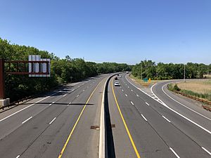
Several important roads pass through Port Republic. The Garden State Parkway goes through the city. You can get on or off at Interchange 48. U.S. Route 9 also runs through Port Republic. Other roads include County Route 575 and County Route 561 Alternate.
Nacote Creek Bridge
The bridge over Nacote Creek in Port Republic is the oldest bridge in Atlantic County. It was built in 1904. This bridge is listed on the New Jersey Register of Historic Places. It needed repairs for a long time. In early 2021, work began to replace it. The new bridge and access roads were finished and reopened in September 2023.
Public Transportation
NJ Transit provides bus services in Port Republic. The 559 bus route connects Lakewood Township to Atlantic City.
Historic Places
Port Republic has several places listed on the National Register of Historic Places. These are important sites because of their history.
- The Amanda Blake Store is located at 104 Main Street. It was added to the list on January 25, 1979.
- The Port Republic Historic District was added on May 16, 1991. This district includes several historic buildings and areas.
Notable People
People who have lived in or are connected to Port Republic include:
- Stephen Dunn (1939–2021), a famous poet who won the Pulitzer Prize for Poetry.
See also
 In Spanish: Port Republic para niños
 | Selma Burke |
 | Pauline Powell Burns |
 | Frederick J. Brown |
 | Robert Blackburn |


