Port de Balès facts for kids
Quick facts for kids Port de Balès |
|
|---|---|

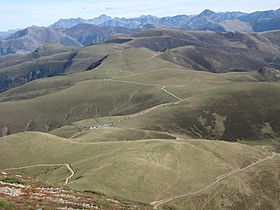
The summit is by the cluster of vehicles
|
|
| Elevation | 1,755 m (5,758 ft) |
| Traversed by | D925/D51 |
| Location | Hautes-Pyrénées, France |
| Range | Pyrenees |
| Coordinates | 42°52′27″N 0°30′03″E / 42.87417°N 0.50083°E |
The Port de Balès (also called Col de Balès) is a mountain pass in the middle of the Pyrenees mountains in France. It's 1,755 meters (5,758 feet) high! This pass connects two small villages: Ferrère in the north and Bourg-d'Oueil in the south-east.
Even though it's often covered in snow during winter, the Port de Balès is a very popular spot for bikers in the summer. It was first used in the 2007 Tour de France and has been a part of the race almost every two or three years since then.
Contents
History of Port de Balès
For a long time, the Port de Balès was a hidden place. It sits between the Barousse valley in the north and the Oueil valley near Bagnères-de-Luchon. Until the early 1980s, there was only one narrow path leading to it from the north.
Then, new forest paths were built above Ferrère. These paths helped people reach the mountain pastures. A few years later, another path was made from Bourg d'Oueil. This path was later extended to the Col de Pierrefite, opening up access to other valleys.
These paths were mostly for farm and forest vehicles. Only cars with four-wheel drive could use them easily. However, the main route over the pass was paved with tarmac in the 1980s. By the late 1990s, this road was in bad shape. It was almost impossible to use until it was repaved in the summer of 2006. This was partly done because the Tour de France organizers wanted new and exciting challenges for the bike riders.
Cycling Races at Port de Balès
The Tour de France bicycle race crossed the Port de Balès for the first time in 2007. This was during Stage 15 of the race. That same stage was also chosen for the 2007 L'Étape du Tour. This is an event where amateur and club cyclists get to ride a full stage of the Tour de France.
During the 2010 Tour de France, something very important happened here. Alberto Contador attacked the race leader, Andy Schleck, on the climb. Schleck had a problem with his bike chain at that moment. Contador kept going and took the yellow jersey, which means he became the overall leader. He won the Tour by 39 seconds. Later, Contador's win was taken away, and Andy Schleck is now officially listed as the winner of the 2010 Tour de France.
How Cyclists Climb Port de Balès
There are two main ways cyclists climb the Port de Balès.
If you start from Mauléon-Barousse, the climb is 18.9 kilometers (11.7 miles) long. Over this distance, cyclists climb 1,185 meters (3,888 feet). The average steepness is 6.3%, but some parts are very steep, over 11%!
If you start from Bagnères-de-Luchon, the climb is 19.7 kilometers (12.2 miles) long. Here, cyclists climb 1,125 meters (3,691 feet). The average steepness is 5.7%, but again, some sections are very steep, over 11%. This southern climb starts near the base of the Col de Peyresourde, another famous climb often used in the Tour de France.
Port de Balès in the Tour de France
The Port de Balès has been a part of the Tour de France several times. Here's a list of when it was included:
| Year | Stage | Category | Start | Finish | Leader at the summit |
|---|---|---|---|---|---|
| 2020 | 8 | HC | Cazères | Loudenvielle | |
| 2017 | 12 | HC | Pau | Peyragudes | |
| 2014 | 16 | HC | Carcassonne | Bagnères-de-Luchon | |
| 2012 | 17 | HC | Bagnères-de-Luchon | Peyragudes | |
| 2010 | 15 | HC | Pamiers | Bagnères-de-Luchon | |
| 2007 | 15 | HC | Foix | Loudenvielle |
Port de Balès in the Vuelta a España
The Vuelta a España is another major bicycle race. It crossed the Port de Balès in 2013.
| Year | Stage | Category | Start | Finish | Leader at the summit |
|---|---|---|---|---|---|
| 2013 | 15 | 1 | Andorra la Vella | Peyragudes |
See also
 In Spanish: Port de Balès para niños
 | Shirley Ann Jackson |
 | Garett Morgan |
 | J. Ernest Wilkins Jr. |
 | Elijah McCoy |


