Carcassonne facts for kids
Quick facts for kids
Carcassonne
Carcassona (Occitan)
|
||
|---|---|---|
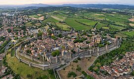
An aerial view of the Cité de Carcassonne
|
||
|
||
| Country | France | |
| Region | Occitanie | |
| Department | Aude | |
| Arrondissement | Carcassonne | |
| Canton | Carcassonne-1, 2 and 3 | |
| Intercommunality | Carcassonne Agglo | |
| Area
1
|
65.08 km2 (25.13 sq mi) | |
| Population
(2022)
|
46,429 | |
| • Density | 713.41/km2 (1,847.73/sq mi) | |
| Time zone | UTC+01:00 (CET) | |
| • Summer (DST) | UTC+02:00 (CEST) | |
| INSEE/Postal code |
11069 /11000
|
|
| Elevation | 81–250 m (266–820 ft) (avg. 111 m or 364 ft) |
|
| 1 French Land Register data, which excludes lakes, ponds, glaciers > 1 km2 (0.386 sq mi or 247 acres) and river estuaries. | ||
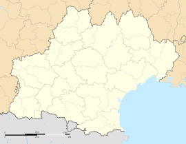
Carcassonne is a famous fortified city in France. It's located in the Aude department, which is part of the Occitania region. Carcassonne is the main city, or "prefecture," of this department.
People have lived here since the Stone Age. Carcassonne sits in a flat area near the Aude River, right on old trade routes. These routes connected the Atlantic Ocean to the Mediterranean Sea and the mountains of the Massif Central to the Pyrénées.
The Romans quickly saw how important this location was. They built a fort on the hilltop and stayed there until their empire ended. Later, in the 5th century, the Visigoths took over and founded the city we know today.
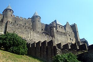
The city's most famous part is its citadel, called the Cité de Carcassonne. This medieval fortress dates back to Roman times. It was carefully restored by an architect named Eugène Viollet-le-Duc between 1853 and 1879. In 1997, UNESCO added it to its list of World Heritage Sites. This was because the medieval fortress was so well-preserved and restored.
Today, Carcassonne is a popular place for tourists. It also has important industries like manufacturing and winemaking.
Contents
- Where is Carcassonne?
- A Look at Carcassonne's Past
- The Amazing Fortified City
- Carcassonne's Weather
- Population
- Carcassonne's Economy
- Education in Carcassonne
- Language Spoken in Carcassonne
- Sports in Carcassonne
- Art and Culture in Carcassonne
- Famous People from Carcassonne
- Carcassonne's Sister Cities
- See also
Where is Carcassonne?
Carcassonne is in the south of France, about 80 kilometers (50 miles) east of Toulouse. Its location between the Atlantic Ocean and the Mediterranean Sea has been important for thousands of years. The city covers about 65 square kilometers (25 square miles). This is much larger than many other small towns in the Aude department. The Aude and Fresquel rivers flow through the city, as does the Canal du Midi.
A Look at Carcassonne's Past
The first signs of people living in this area are from around 3500 BC. The hill where the city stands, once called Carsac, became an important trading spot in the 6th century BC. A Celtic tribe, the Volcae Tectosages, built a fort there and named it "Carsac."
The Legend of Lady Carcas
There's a fun story about how Carcassonne got its name. It tells of a brave lady named Lady Carcas who saved the city during a siege. She used a clever trick to make the attackers think the city had plenty of food. When the siege ended, she rang the bells ("Carcas sona" in French). This legend is remembered with a statue of Lady Carcas near the Narbonne Gate.
Roman Times and Beyond
The Romans saw how important Carcassonne was and fortified the hilltop around 100 BC. They made it a Roman colony called Julia Carsaco, which later became Carcaso. Parts of the old northern walls still show Roman building styles. In AD 462, the Romans gave the region to the Visigoths, who had already controlled Carcassonne since AD 453.
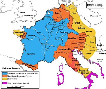
The Visigothic king Theodoric II is thought to have started building a church, which is now the Basilica of Saint Nazaire. In AD 508, the Visigoths successfully defended against attacks from the Frankish king Clovis I. Later, in AD 719, Arab and Berber Muslim forces invaded the region. They were defeated by the Christian Franks in AD 759 and left the area.
Medieval Carcassonne and the Crusades
During the Middle Ages, Carcassonne was a powerful area ruled by counts. In 1067, it became part of the Trencavel family's lands. This family built the Château Comtal (Count's Castle) and the Basilica of Saints Nazarius and Celsus. In 1096, Pope Urban II blessed the start of a new cathedral.
Carcassonne played a big role in the Albigensian Crusades. The city was a stronghold for the Cathars, a religious group. In August 1209, a crusader army forced the city to surrender. The viscount, Raymond-Roger de Trencavel, was imprisoned and died mysteriously. The people of Carcassonne were forced to leave their homes with almost nothing. Simon de Montfort became the new ruler and made the city's defenses even stronger.
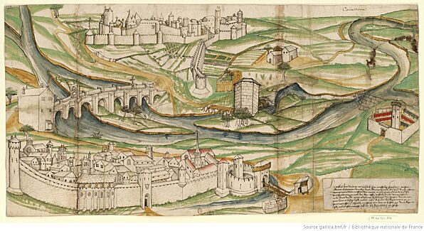
In 1240, Trencavel's son tried to take back the city but failed. Carcassonne then became part of the Kingdom of France in 1247. It was an important border fortress between France and the Crown of Aragon. King Louis IX and Philip III built new outer walls and a new part of the town across the river. The fortress was considered unbeatable. During the Hundred Years' War, Edward the Black Prince tried to capture it in 1355 but couldn't, though his troops did destroy the lower town.
A Changing City
In 1659, the border moved, and Carcassonne was no longer as important for defense. Its forts were left alone, and the city became known for making wool textiles. This industry was very important until the late 1700s. The town hall, called Hôtel de Rolland, was finished in 1761.
The Amazing Fortified City
The fortified city, or Cité, is designed with two main outer walls and 52 towers. These were built to protect against attacks. The castle inside has its own drawbridge and ditch. The walls were built over a long time. One part is Roman and looks different from the medieval walls, with red brick layers and flat tile roofs. One tower was even used by the Catholic Inquisition in the 13th century and is still called "The Inquisition Tower."
Saving Carcassonne's Walls
After Napoleon Bonaparte's time, Carcassonne's fortified city fell into disrepair. The French government even thought about tearing it down in 1849! But people like Jean-Pierre Cros-Mayrevieille, the mayor, and writer Prosper Mérimée fought to save it. They wanted to protect it as a historical monument.
Later that year, architect Eugène Viollet-le-Duc was hired to restore the city. He had already been working on the Basilica of Saints Nazarius and Celsus. Work began in 1853, focusing on the walls and towers. Viollet-le-Duc made sure the roofs of the towers and ramparts were fixed. He also removed buildings that had been built against the old walls. He left many notes and drawings when he died in 1879, and his students continued the restoration.
Some people criticized Viollet-le-Duc's work. He used slate roofs, which were more common in northern France, instead of the local terracotta tiles. He also added pointed tips to the roofs, which some felt didn't fit the original style.
The Lower Town
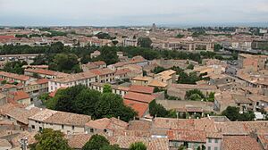
The Lower Town (ville basse) was built in the Late Middle Ages. It was founded by people who had been forced out of the fortified city after the crusades. For centuries, this part of the city has been its economic center. While it once had walls, most of them are gone now. The Carcassonne Cathedral is located in the Lower Town.
Other Interesting Places
Another bridge, Pont Marengo, crosses the Canal du Midi and leads to the train station. The Lac de la Cavayère is a lake created for fun activities, just a short drive from the city center.
Other sights include:
- The Basilica of Saints Nazarius and Celsus
- The Carcassonne Cathedral
- Church of St. Vincent
Carcassonne's Weather
Carcassonne has a climate with warm, wet winters and hot, dry summers. Summer temperatures often go above 28°C (82°F) during the day. Like other parts of the French Mediterranean coast, Carcassonne can experience strong thunderstorms and heavy rains in late summer and early autumn. These can sometimes cause floods, as happened in October 2018.
| Climate data for Carcassonne (1991–2020 normals, extremes 1948–present) | |||||||||||||
|---|---|---|---|---|---|---|---|---|---|---|---|---|---|
| Month | Jan | Feb | Mar | Apr | May | Jun | Jul | Aug | Sep | Oct | Nov | Dec | Year |
| Record high °C (°F) | 21.1 (70.0) |
25.2 (77.4) |
27.3 (81.1) |
31.3 (88.3) |
35.2 (95.4) |
40.7 (105.3) |
40.2 (104.4) |
43.2 (109.8) |
36.4 (97.5) |
31.9 (89.4) |
26.2 (79.2) |
22.4 (72.3) |
43.2 (109.8) |
| Mean daily maximum °C (°F) | 10.0 (50.0) |
11.4 (52.5) |
14.9 (58.8) |
17.7 (63.9) |
21.4 (70.5) |
25.9 (78.6) |
28.8 (83.8) |
28.9 (84.0) |
24.8 (76.6) |
19.7 (67.5) |
13.9 (57.0) |
10.7 (51.3) |
19.0 (66.2) |
| Daily mean °C (°F) | 6.7 (44.1) |
7.5 (45.5) |
10.4 (50.7) |
12.9 (55.2) |
16.5 (61.7) |
20.5 (68.9) |
23.1 (73.6) |
23.1 (73.6) |
19.4 (66.9) |
15.5 (59.9) |
10.4 (50.7) |
7.4 (45.3) |
14.4 (57.9) |
| Mean daily minimum °C (°F) | 3.5 (38.3) |
3.5 (38.3) |
5.9 (42.6) |
8.1 (46.6) |
11.6 (52.9) |
15.1 (59.2) |
17.3 (63.1) |
17.3 (63.1) |
14.1 (57.4) |
11.3 (52.3) |
6.9 (44.4) |
4.2 (39.6) |
9.9 (49.8) |
| Record low °C (°F) | −12.5 (9.5) |
−15.2 (4.6) |
−7.5 (18.5) |
−1.6 (29.1) |
0.9 (33.6) |
6.0 (42.8) |
8.4 (47.1) |
8.2 (46.8) |
2.5 (36.5) |
−2.0 (28.4) |
−6.8 (19.8) |
−12.0 (10.4) |
−15.2 (4.6) |
| Average precipitation mm (inches) | 66.0 (2.60) |
46.6 (1.83) |
58.4 (2.30) |
71.4 (2.81) |
63.1 (2.48) |
46.8 (1.84) |
30.1 (1.19) |
39.8 (1.57) |
48.4 (1.91) |
62.7 (2.47) |
70.3 (2.77) |
61.4 (2.42) |
665.0 (26.18) |
| Average precipitation days (≥ 1.0 mm) | 9.5 | 7.6 | 7.8 | 9.3 | 7.8 | 5.6 | 4.6 | 5.1 | 5.6 | 7.2 | 9.0 | 8.5 | 87.7 |
| Average snowy days | 2.1 | 2.1 | 0.9 | 0.3 | 0.0 | 0.0 | 0.0 | 0.0 | 0.0 | 0.0 | 0.6 | 1.4 | 7.4 |
| Average relative humidity (%) | 82 | 79 | 74 | 74 | 72 | 69 | 64 | 68 | 73 | 80 | 82 | 84 | 75.1 |
| Mean monthly sunshine hours | 95.4 | 121.9 | 173.8 | 192.2 | 220.1 | 247.8 | 282.5 | 267.8 | 216.0 | 152.2 | 104.6 | 95.2 | 2,169.5 |
| Source 1: Meteociel | |||||||||||||
| Source 2: Infoclimat.fr (humidity and snowy days, 1961–1990) | |||||||||||||
Population
| Historical population | ||||||||||||||||||||||||||||||||||||||||||||||||||||||||||||||||||||||||||||||||||||||||||||||||||||||||||||||||||||||||||
|---|---|---|---|---|---|---|---|---|---|---|---|---|---|---|---|---|---|---|---|---|---|---|---|---|---|---|---|---|---|---|---|---|---|---|---|---|---|---|---|---|---|---|---|---|---|---|---|---|---|---|---|---|---|---|---|---|---|---|---|---|---|---|---|---|---|---|---|---|---|---|---|---|---|---|---|---|---|---|---|---|---|---|---|---|---|---|---|---|---|---|---|---|---|---|---|---|---|---|---|---|---|---|---|---|---|---|---|---|---|---|---|---|---|---|---|---|---|---|---|---|---|---|
|
|
|
||||||||||||||||||||||||||||||||||||||||||||||||||||||||||||||||||||||||||||||||||||||||||||||||||||||||||||||||||||||||
| Source: EHESS and INSEE (1968–2017) | ||||||||||||||||||||||||||||||||||||||||||||||||||||||||||||||||||||||||||||||||||||||||||||||||||||||||||||||||||||||||||
Carcassonne's Economy
The newer part of the city, the Ville Basse, makes shoes, rubber, and textiles. It's also a big center for making AOC wines. A lot of the city's money comes from tourists visiting the fortified city and from boats on the Canal du Midi. Carcassonne gets about three million visitors every year.
Getting Around Carcassonne
Carcassonne airport started offering budget flights to European cities in the late 1990s. The Gare de Carcassonne train station has direct connections to major French cities like Toulouse, Narbonne, and Paris. The A61 motorway also connects Carcassonne to Toulouse and Narbonne.
Education in Carcassonne
- École nationale de l'aviation civile (National School of Civil Aviation)
Language Spoken in Carcassonne
While French is spoken, the historical language of Carcassonne and the Languedoc-Roussillon region was Occitan.
Sports in Carcassonne
Carcassonne is a popular stop for the Tour de France cycling race. In July 2025, it was the finish city for stage 15, where Tim Wellens won. In July 2021, Carcassonne was the finish city for stage 13. Here, Mark Cavendish tied the record for most Tour de France stage wins (34) held by Eddy Merckx.
| Year | Stage | Start of stage | Stage finish | Distance (km) | Stage winner |
|---|---|---|---|---|---|
| 1947 | 13 | Montpellier | Carcassonne | 172 | |
| 14 | Carcassonne | Luchon | 253 | ||
| 1951 | 15 | Luchon | Carcassonne | 213 | |
| 16 | Carcassonne | Montpellier | 192 | ||
| 1962 | 14 | Luchon | Carcassonne | 215 | |
| 15 | Carcassonne | Montpellier | 196.5 | ||
| 1981 | 4 | Narbonne | Carcassonne | 77 | TI–Raleigh–Creda (TTT) |
| 1986 | 15 | Carcassonne | Nîmes | 225.5 | |
| 2004 | 14 | Carcassonne | Nîmes | 192.5 | |
| 2006 | 12 | Luchon | Carcassonne | 211.5 | |
| 2014 | 16 | Carcassonne | Bagnères-de-Luchon | 237.5 | |
| 2016 | 11 | Carcassonne | Montpellier | 162.5 | |
| 2018 | 15 | Millau | Carcassonne | 181.5 | |
| 16 | Carcassonne | Bagnères-de-Luchon | 218 | ||
| 2021 | 13 | Nîmes | Carcassonne | 219.9 | |
| 14 | Carcassonne | Quillan | 183.7 | ||
| 2022 | 15 | Rodez | Carcassonne | 202.5 | |
| 16 | Carcassonne | Foix | 178.5 | ||
| 2025 | 15 | Muret | Carcassonne | 169.3 |
Like in other parts of southwest France, rugby union is very popular in Carcassonne. The local team is called Union Sportive Carcassonnaise, or USC. They have a long history and play in Pro D2, the second-highest level of French rugby.
Rugby league is also played by the AS Carcassonne club. They compete in the Elite One Championship. A famous rugby league player from Carcassonne, Puig Aubert, has a bronze statue outside the Stade Albert Domec. This is where both rugby teams play.
Art and Culture in Carcassonne
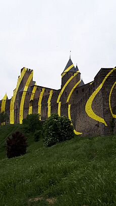
In May 2018, a special art project called "Concentric, eccentric" by artist Felice Varini was displayed on the fortress walls. Large yellow circles were placed on the monument. This was part of an art event celebrating the 20th anniversary of Carcassonne becoming a UNESCO World Heritage Site.
The artwork was huge and could be seen across the western side of the fortifications. You could see the full effect of the circles from in front of the Porte d'Aude. The yellow circles were made of thin aluminum sheets. They looked like waves, breaking up and then coming back together as you moved around the towers and walls. This amazing artwork was only visible from May to September 2018.
Carcassonne in Stories and Games
- The French poet Gustave Nadaud wrote a famous poem about a man who dreamed of seeing Carcassonne but couldn't before he died. This poem has inspired many others.
- On March 6, 2000, France released a stamp honoring the fortress of Carcassonne.
- In 2000, a popular board game called Carcassonne (board game) was released. The game's creator, Klaus-Jürgen Wrede, was so impressed by the city and its surroundings that he wanted to make a game about it.
- Carcassonne was the inspiration for a map in the video game "Black Ops 6 Zombie" called "Citadelle des Morts" (Citadel of the Dead).
- The book Narrow Dog to Carcassonne tells the story of a couple's trip from England to France on their narrowboat, with Carcassonne as their destination.
Famous People from Carcassonne
- Paul Lacombe, a French composer, born in 1837
- Théophile Barrau, a French sculptor, born in 1848
- Paul Sabatier, a French chemist who won the Nobel Prize in Chemistry, born in 1854
- Henry d'Estienne, a French painter, born in 1872
- Suzanne Sarroca, a French opera singer, born in 1927
- Gilbert Benausse, a French rugby league player, born in 1932
- Alain Colmerauer, a French computer scientist who invented the programming language Prolog, born in 1941
- Michael Martchenko, a French-born Canadian illustrator, born in 1942
- Maurice Sarrail, a French soldier and General during the First World War, born in 1856
- David Ferriol, a French rugby league player, born in 1979
- Olivia Ruiz, a French pop singer, born in 1980
- Fabrice Estebanez, a French rugby union player, born in 1981
Carcassonne's Sister Cities
Carcassonne has sister cities around the world:
 Eggenfelden, Germany
 Baeza, Spain
 Tallinn, Estonia
See also
 In Spanish: Carcasona para niños
 | Isaac Myers |
 | D. Hamilton Jackson |
 | A. Philip Randolph |


