Porter, Washington facts for kids
Quick facts for kids
Porter, Washington
|
|
|---|---|

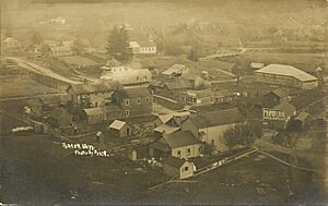
Porter, Washington, early 20th century
|
|
| Country | United States |
| State | Washington |
| County | Grays Harbor |
| Area | |
| • Total | 8.9 sq mi (23.0 km2) |
| • Land | 8.9 sq mi (23.0 km2) |
| • Water | 0 sq mi (0.0 km2) |
| Elevation | 100 ft (30 m) |
| Population
(2020)
|
|
| • Total | 204 |
| • Density | 22.97/sq mi (8.87/km2) |
| Time zone | UTC-8 (Pacific (PST)) |
| • Summer (DST) | UTC-7 (PDT) |
| ZIP code |
98541
|
| Area code(s) | 360 |
| FIPS code | 53-55540 |
Porter is a small community in Grays Harbor County, Washington, United States. It is an unincorporated community, meaning it does not have its own local government. It is also a census-designated place (CDP), which is an area defined by the U.S. Census Bureau for collecting population data.
In 2020, about 204 people lived in Porter. This was a slight decrease from 207 people in 2010. Before 2010, Porter was part of a larger CDP called Malone-Porter. Now, Malone and Porter are separate CDPs. They are located near U.S. Route 12, southeast of Elma and northwest of Oakville. A short railway line, part of the Puget Sound and Pacific Railroad, also runs through the area.
A Look Back at Porter's History
Porter was named after Fairchild Porter. He was one of the first settlers in the area, arriving around 1860.
In 1923, a local group called the Porter Grange No. 800 started in the community. This group was part of the National Grange, an organization that helps farmers and promotes community life. The Porter Grange later became known as the Sharon Grange, located in Oakville.
A big fire destroyed much of Porter on January 31, 1924. However, the community began to rebuild. The Porter Saloon, a local business, was rebuilt later that same year. In 1933, after a time called Prohibition ended, the saloon reopened. During Prohibition, it was illegal to make or sell alcoholic drinks. When Prohibition ended, the Porter Saloon was one of the very first places in Washington state to get a license to sell alcohol again.
Where is Porter Located?
Porter is found in the southeastern part of Grays Harbor County. It is east of the Chehalis River valley, near where Porter Creek flows into it. The CDP stretches northeast along the Porter Creek valley and east towards the first hills of the local Black Hills.
To the northwest, Porter borders the Malone CDP. To the west, it is next to U.S. Route 12. This highway goes west about 27 miles (43 km) to Aberdeen. It also goes southeast about 19 miles (31 km) to Grand Mound and Interstate 5.
The United States Census Bureau states that the Porter CDP covers a total area of 23.0 square kilometers (about 8.9 square miles). All of this area is land, with no water.
See also
 In Spanish: Porter (Washington) para niños
 | Shirley Ann Jackson |
 | Garett Morgan |
 | J. Ernest Wilkins Jr. |
 | Elijah McCoy |


