
Primus Peak facts for kids
Quick facts for kids Primus Peak |
|
|---|---|

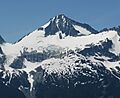
Primus Peak seen from Ruby Mountain
|
|
| Highest point | |
| Elevation | 8,508 ft (2,593 m) |
| Prominence | 828 ft (252 m) |
| Geography | |

Primus Peak
Location in Washington (state)

Primus Peak
Location in the United States
|
|
| Location | North Cascades National Park, Washington, U.S. |
| Parent range | Cascade Range |
| Topo map | USGS Forbidden Peak |

Primus Peak is a tall mountain in the North Cascades National Park in Washington, USA. It stands about 8,508 feet (2,593 m) high. The mountain is surrounded by two large ice fields: the North Klawatti Glacier to the south and the Borealis Glacier to the northeast. Another peak, Tricouni Peak, is located just east of Primus Peak.
Contents
Mountain Climate
Weather Patterns
Primus Peak is in a "marine west coast" climate zone. This means it gets a lot of moisture from the Pacific Ocean. Most weather systems start over the Pacific. They then move northeast towards the Cascade Mountains.
Rain and Snowfall
When these weather systems hit the tall peaks of the North Cascades, the air is forced to rise. As the air goes up, it cools and drops its moisture. This process is called orographic lift. It causes a lot of rain or snowfall on the western side of the North Cascades.
Seasonal Weather
The western Cascades get a lot of rain and snow, especially in winter. Winters are often cloudy. However, in summer, high pressure systems over the Pacific Ocean become stronger. This often leads to clear skies and sunny weather. Because of the ocean's influence, the snow here can be wet and heavy. This type of snow can increase the risk of avalanches.
Geology of Primus Peak
Rugged Landscape
The North Cascades area has very rugged land. You can see sharp peaks, tall spires, and deep valleys carved by glaciers. These unique shapes and big changes in height were created by geological events over millions of years. These events also led to the different climates found across the Cascade Range.
How the Mountains Formed
The Cascade Range began forming millions of years ago. This happened when the North American Plate slowly moved over the Pacific Plate. This movement caused many volcanic eruptions. Also, small pieces of the Earth's crust, called terranes, joined together. This helped create the North Cascades about 50 million years ago.
Impact of Glaciers
About two million years ago, during the Pleistocene period, glaciers repeatedly moved across the land. As they advanced and retreated, they scraped away rock and left behind debris. This action created the "U"-shaped valleys you see today. The combination of land rising (called uplift) and cracks in the Earth's crust (called faulting) with glaciation has shaped the tall peaks and deep valleys of the North Cascades.
Images for kids
-
Primus Peak seen from Ruby Mountain
-
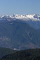
Primus Peak (left skyline with large shadowed northwest face); Austera Peak (indistinct ridge on skyline); Klawatti Peak (center skyline); Dorado Needle (far right skyline); Little Devil Peak (left middle distance)
