
Protected areas of Tasmania facts for kids
[ { "type": "ExternalData", "service": "geoshape", "ids": "Q816402", "properties": { "title": "Ben Lomond National Park", "fill": "#014C01", "stroke": "#447F06", "stroke-width": 0 } }, { "type": "ExternalData", "service": "geoshape", "ids": "Q1138453", "properties": { "title": "Cradle Mountain-Lake St Clair National Park", "fill": "#447F06", "stroke": "#447F06", "stroke-width": 0 } }, { "type": "ExternalData", "service": "geoshape", "ids": "Q1251931", "properties": { "title": "Douglas-Apsley National Park", "fill": "#447F06", "stroke": "#447F06", "stroke-width": 0 } }, { "type": "ExternalData", "service": "geoshape", "ids": "Q1445146", "properties": { "title": "Franklin-Gordon Wild Rivers National Park", "fill": "#014C01", "stroke": "#447F06", "stroke-width": 0 } }, { "type": "ExternalData", "service": "geoshape", "ids": "Q930677", "properties": { "title": "Freycinet National Park", "fill": "#014C01", "stroke": "#447F06", "stroke-width": 0 } }, { "type": "ExternalData", "service": "geoshape", "ids": "Q827519", "properties": { "title": "Hartz Mountains National Park", "fill": "#014C01", "stroke": "#447F06", "stroke-width": 0 } }, { "type": "ExternalData", "service": "geoshape", "ids": "Q250574", "properties": { "title": "Kent Group National Park", "fill": "#447F06", "stroke": "#447F06", "stroke-width": 0 } }, { "type": "ExternalData", "service": "geoshape", "ids": "Q940680", "properties": { "title": "Maria Island National Park", "fill": "#447F06", "stroke": "#447F06", "stroke-width": 0 } }, { "type": "ExternalData", "service": "geoshape", "ids": "Q827526", "properties": { "title": "Mole Creek Karst National Park", "fill": "#447F06", "stroke": "#447F06", "stroke-width": 0 } }, { "type": "ExternalData", "service": "geoshape", "ids": "Q1905973", "properties": { "title": "Mount Field National Park", "fill": "#447F06", "stroke": "#447F06", "stroke-width": 0 } }, { "type": "ExternalData", "service": "geoshape", "ids": "Q491972", "properties": { "title": "Mount William National Park", "fill": "#447F06", "stroke": "#447F06", "stroke-width": 0 } }, { "type": "ExternalData", "service": "geoshape", "ids": "Q1465468", "properties": { "title": "Narawntapu National Park", "fill": "#014C01", "stroke": "#447F06", "stroke-width": 0 } }, { "type": "ExternalData", "service": "geoshape", "ids": "Q655191", "properties": { "title": "Rocky Cape National Park", "fill": "#014C01", "stroke": "#447F06", "stroke-width": 0 } }, { "type": "ExternalData", "service": "geoshape", "ids": "Q519117", "properties": { "title": "Savage River National Park", "fill": "#447F06", "stroke": "#447F06", "stroke-width": 0 } }, { "type": "ExternalData", "service": "geoshape", "ids": "Q830099", "properties": { "title": "South Bruny National Park", "fill": "#447F06", "stroke": "#447F06", "stroke-width": 0 } }, { "type": "ExternalData", "service": "geoshape", "ids": "Q967541", "properties": { "title": "Southwest National Park", "fill": "#447F06", "stroke": "#447F06", "stroke-width": 0 } }, { "type": "ExternalData", "service": "geoshape", "ids": "Q2016058", "properties": { "title": "Strzelecki National Park", "fill": "#014C01", "stroke": "#447F06", "stroke-width": 0 } }, { "type": "ExternalData", "service": "geoshape", "ids": "Q925214", "properties": { "title": "Tasman National Park", "fill": "#014C01", "stroke": "#447F06", "stroke-width": 0 } }, { "type": "ExternalData", "service": "geoshape", "ids": "Q385655", "properties": { "title": "Walls of Jerusalem National Park", "fill": "#014C01", "stroke": "#447F06", "stroke-width": 0 } } ]
</mapframe>Tasmania is an amazing island with lots of special places! These places are called protected areas. They are like nature's own safe zones, set aside to keep Tasmania's unique plants, animals, and beautiful landscapes safe. This includes land and the waters right around the island, even Macquarie Island far to the south.
More than half of Tasmania's land (about 52%) is protected in some way. Most of these areas are looked after by the Tasmania Parks and Wildlife Service. The waters around Tasmania are also protected, with about 7.9% of them being special marine protected areas.
Contents
Looking After Our Protected Areas
Different groups help manage Tasmania's protected areas. They follow special rules to make sure these places stay healthy and beautiful for everyone.
- The Tasmania Parks and Wildlife Service manages public land under the Nature Conservation Act 2002. They look after 10 types of protected areas, like national parks and nature reserves.
- Sustainable Timber Tasmania manages some public land where trees are grown for timber. Even here, they have special "informal reserves" to protect things like streams and animal pathways.
- The Department of Primary Industries, Parks, Water and Environment (DPIPWE) also looks after some public land that might be used for timber in the future, but for now, it's mostly protected.
- Wellington Park, which includes Mount Wellington near Hobart, has its own special group that looks after it.
How Much Land is Protected?
As of 2016, a huge part of Tasmania's land – about 3.4 million hectares – is protected. That's more than half of the whole island! The Tasmania Parks and Wildlife Service manages most of this, looking after 823 different protected spots.
Here's a quick look at the main types of protected land and how much area they cover:
| Operator | Type of Protected Area | Number | Total Area (hectares) |
Percentage of all protected land | ||||||||||||||||||||||||||||||||||||||||||||||||||||||||||||||||||||||||||||||||||||||||||||||
|---|---|---|---|---|---|---|---|---|---|---|---|---|---|---|---|---|---|---|---|---|---|---|---|---|---|---|---|---|---|---|---|---|---|---|---|---|---|---|---|---|---|---|---|---|---|---|---|---|---|---|---|---|---|---|---|---|---|---|---|---|---|---|---|---|---|---|---|---|---|---|---|---|---|---|---|---|---|---|---|---|---|---|---|---|---|---|---|---|---|---|---|---|---|---|---|---|---|---|
| TPWS | Conservation Area | 438 | 622,000 | 18.2% | ||||||||||||||||||||||||||||||||||||||||||||||||||||||||||||||||||||||||||||||||||||||||||||||
| Game Reserve | 12 | 13,000 | 0.4% | |||||||||||||||||||||||||||||||||||||||||||||||||||||||||||||||||||||||||||||||||||||||||||||||
| Historic Site | 30 | 9,000 | 0.3% | |||||||||||||||||||||||||||||||||||||||||||||||||||||||||||||||||||||||||||||||||||||||||||||||
| National Park | 19 | 1,463,000 | 42.9% | |||||||||||||||||||||||||||||||||||||||||||||||||||||||||||||||||||||||||||||||||||||||||||||||
| Nature Recreation Area | 25 | 67,000 | 2.0% | |||||||||||||||||||||||||||||||||||||||||||||||||||||||||||||||||||||||||||||||||||||||||||||||
| Nature Reserve | 86 | 35,000 | 1.0% | |||||||||||||||||||||||||||||||||||||||||||||||||||||||||||||||||||||||||||||||||||||||||||||||
| Regional Reserve | 148 | 454,000 | 13.3% | |||||||||||||||||||||||||||||||||||||||||||||||||||||||||||||||||||||||||||||||||||||||||||||||
| State Reserve | 65 | 46,000 | 1.4% | |||||||||||||||||||||||||||||||||||||||||||||||||||||||||||||||||||||||||||||||||||||||||||||||
| Total managed by TPWS |
823 | 2,709,000 | 79.3% | |||||||||||||||||||||||||||||||||||||||||||||||||||||||||||||||||||||||||||||||||||||||||||||||
| STT | Informal Reserve | N/A | 121,000 | 3.6% | ||||||||||||||||||||||||||||||||||||||||||||||||||||||||||||||||||||||||||||||||||||||||||||||
| DPIPWE | Future Potential Production Forest | N/A | 392,000 | 11.5% | ||||||||||||||||||||||||||||||||||||||||||||||||||||||||||||||||||||||||||||||||||||||||||||||
| Other | Other not managed by TPWS or STT |
N/A | 192,000 | 5.6% | ||||||||||||||||||||||||||||||||||||||||||||||||||||||||||||||||||||||||||||||||||||||||||||||
| N/A | Total of all Tasmanian protected area |
N/A | 3,415,000 | 100% | ||||||||||||||||||||||||||||||||||||||||||||||||||||||||||||||||||||||||||||||||||||||||||||||
| *rounded to the nearest 1,000 hectares Department of Primary Industries, Water and Environment is DPIPWE, Sustainable Timber Tasmania is STT, and Tasmania Parks & Wildlife Service is TPWS |
||||||||||||||||||||||||||||||||||||||||||||||||||||||||||||||||||||||||||||||||||||||||||||||||||
Marine Protected Areas
Just like land, the ocean around Tasmania also has special protected zones.
Commonwealth Marine Reserves
These are large ocean areas managed by the Australian Government and are not directly in Tasmania's state waters. They are part of a bigger network called the South-east Commonwealth Marine Reserve Network.
Some of these reserves near Tasmania include:
Tasmanian Marine Protected Areas
These are protected areas within Tasmania's own waters. They are classed as conservation areas, national parks, or nature reserves. Some of these areas have rules about fishing, or are "no-take zones" where no fishing is allowed at all.
About 7.9% of Tasmania's coastal waters are protected. A large part of the fully protected "no-take" zones are around Macquarie Island.
Private Protected Areas
Not all protected areas are on public land. About 4% of Tasmania's protected land is privately owned.
Conservation Covenants
Sometimes, landowners agree to protect parts of their land with a "Conservation Covenant." This is a legal agreement that helps keep the natural values of the land safe, usually forever. As of 2016, there were 819 such agreements covering about 99,000 hectares.
Indigenous Protected Areas
These are areas of land and sea that are managed by Indigenous communities to protect their cultural and natural heritage. There are 8 Indigenous Protected Areas in Tasmania, covering about 11,000 hectares.
Some examples include:
- Babel Island
- Badger Island
- Great Dog Island
- Preminghana
Wellington Park
Wellington Park is a protected area that surrounds Mount Wellington near Hobart. It covers about 18,000 hectares and is managed by a special group called the Wellington Park Management Trust. This group includes representatives from local councils and government departments.
State Forests
Some areas are managed for timber production but also have protected zones within them.
Future Potential Production Forests
These are public lands where, for now, native forests cannot be harvested for timber. They were once called "future reserve land." After 2020, some of these areas might be changed into "permanent timber production zones" where logging could happen, but only with special approval.
Permanent Timber Production Zone Land
This land is managed by Sustainable Timber Tasmania for growing and harvesting timber. However, even within these areas, there are "informal reserves" that protect important habitats for animals, streams, and natural pathways. About 121,000 hectares of this land have these informal protections.
Forest Reserves
These are special areas within the timber production zones that are set aside for recreation and tourism, like walking trails or scenic spots.
Some examples are:
- Hollybank
- Tahune
Conservation Areas
A conservation area is a protected piece of land that is mostly natural. Some activities like mining, special timber harvesting, or hunting might be allowed, but only if they don't harm the natural environment. There are 438 conservation areas in Tasmania, covering about 622,000 hectares.
-
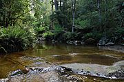
Rainforest in the Liffey Falls Conservation Area
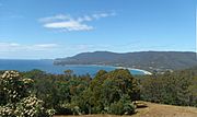
-
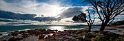
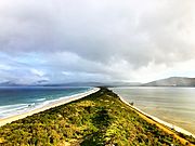
Looking towards Great Oyster Bay, Coles Bay Conservation Area
-
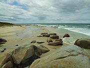
Conservation Area at St Helens


Some well-known conservation areas include:
- Liffey
- Styx Tall Trees
- Coles Bay
- Arthur-Pieman
Marine Conservation Areas
These are protected areas in Tasmania's state waters. They cover about 12,000 hectares. While they are protected, they don't have any fishing restrictions.
Examples include:
- Huon Estuary
- South Arm
Game Reserves
Game reserves are special areas where certain animal species, often those that can be hunted, are protected. They allow for sustainable hunting, meaning hunting is managed so that animal populations stay healthy. There are 12 game reserves in Tasmania, covering about 20,000 hectares.
-
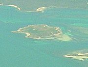
Little Dog Island
-
Bruny Island Neck


Some game reserves are:
Historic Sites
Historic sites are places that are important because of their history and culture. They are protected so people can learn about the past. There are 30 historic sites in Tasmania, covering about 16,000 hectares.
-
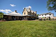
Entally House, Hadspen
-
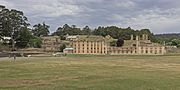
Port Arthur Historic Site
-
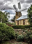
Callington Mill, Oatlands


Famous historic sites include:
- Port Arthur
- Cascades Female Factory
- Richmond Gaol
- Callington Mill
National Parks
National parks in Tasmania are large, natural areas that protect important natural features, scenery, and wildlife. They are also places where people can enjoy nature in a way that doesn't harm the environment. National parks are the largest type of protected area in Tasmania, with 19 parks covering about 1,468,000 hectares.
Some of Tasmania's most famous national parks are:
National Parks (Marine)
Some national parks also include parts of the ocean, protecting marine life and habitats. These marine areas cover about 48,000 hectares of state waters.
Examples include marine parts of:
- Kent Group
- Maria Island
- Southwest (including Port Davey/Bathurst)
Nature Recreation Areas
These areas are mostly natural and are set aside for public recreation and education, while still protecting the environment. There are 25 nature recreation areas, covering about 67,000 hectares.
-
Pirates Bay
-
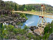
Alexandra Bridge near Trevallyn Nature Recreation Area
-
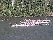
Lake Barrington near Devonport


Some popular nature recreation areas are:
- Pirates Bay
- Trevallyn
- Lake Barrington
Nature Reserves
Nature reserves are protected areas that keep Tasmania's unique plants, animals, and geological features safe. They are very important for protecting biodiversity. There are 86 nature reserves, covering about 36,000 hectares.
-
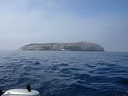
Ile des Phoques from the south
-
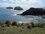
The Doughboys
-
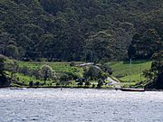
Boat ramp and Tinderbox

.jpg)

Key nature reserves include:
- Macquarie Island (World Heritage)
- Albatross Island
- Tinderbox
Marine Nature Reserves
These are nature reserves that protect marine environments. They cover about 76,000 hectares of state waters, including the large area around Macquarie Island.
Examples are:
- Governor Island
- Ninepin Point
Regional Reserves
Regional reserves are areas that are mostly natural but might also have valuable minerals or other natural resources. They are protected to allow for careful mineral exploration or other resource use, while still looking after the natural and cultural values. There are 148 regional reserves, covering about 454,000 hectares.
Some regional reserves include:
- Blue Tier
- Leven Canyon
- Mount Roland
State Reserves
State reserves protect important natural landscapes, features, or places that are special to Aboriginal people. There are 65 state reserves, covering about 47,000 hectares.
Some examples are:
- Liffey Falls
- Hastings Caves
- The Nut
- Tessellated Pavement
