
Port Davey facts for kids
Quick facts for kids Port Davey(Poynduc) |
|
|---|---|

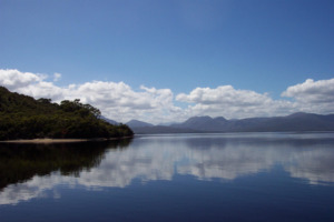
Celery Top Islands
|
|

Port Davey
(Poynduc) Location in Tasmania
|
|
| Location | South Western Tasmania |
| Coordinates | 43°19′48″S 145°54′36″E / 43.33000°S 145.91000°E |
| Etymology | Thomas Davey, a former Governor of Tasmania |
| River sources | Davey River |
| Ocean/sea sources | Southern Ocean |
| Basin countries | Australia |
Port Davey is a large ocean inlet found in the southwest part of Tasmania, Australia. It was named after Thomas Davey, who used to be the Governor of Tasmania. The local Indigenous people, the Toogee, called it Poynduc.
Port Davey is a very special place. It is protected as part of the Port Davey/Bathurst Harbour Marine Nature Reserve. It's also within the Melaleuca to Birchs Inlet Important Bird Area, which means it's a key spot for birds. Plus, it's part of the Southwest National Park, which is itself a part of the amazing Tasmanian Wilderness World Heritage Area. This means it's recognized globally for its natural beauty and importance.
In 1941, an Australian journalist named Critchley Parker suggested that Port Davey could be a new home for Jewish refugees who were escaping danger in Europe. The leader of Tasmania at the time, Robert Cosgrove, even supported this idea.
Contents
Exploring Port Davey's Past
The first European to write about Port Davey was a French explorer named Marc-Joseph Marion du Fresne. He saw the inlet in March 1772. Later, in 1798, Matthew Flinders also noted it on his maps. Although James Kelly is often given credit for discovering Port Davey, he likely used Flinders' maps.
In the 1800s, a small village of piners lived on Payne Bay, which is part of Port Davey. Piners were people who cut down Huon pine trees for wood. They had a boatyard there until the early 1900s when the Huon Pine trade stopped. Another temporary village was at Bramble Cove. This was used by whalers in the early 1800s. Whaling ships would come into Port Davey to get wood, water, and vegetables. They also processed whales they caught in the calm waters. Today, only a few old gravestones from a cemetery remain.
Early maps from the 1800s showed a planned settlement called Bathurst in the Port Davey area. Its exact location changed on different maps. Places like Bramble Cove and Joe Page Bay were considered. But by the Victorian era, the idea of this settlement was dropped.
In 1910, a brave pilot named Francis McClean led a trip to Port Davey. They wanted to watch a solar eclipse on May 9. They faced a lot of rain, but also a bush fire that nearly destroyed their equipment. Sadly, the weather was too cloudy on the day of the eclipse, so they couldn't see it.
The first civilian airplane to land in Port Davey was a Catalina PBY 5 flying boat. It landed on July 8, 1947. The plane was meant to carry fresh seafood from fishing boats in Port Davey to cities like Adelaide and Melbourne. However, this business didn't last long. Fishing boats like the Pacific Pride and Diane also used Port Davey in 1947 to catch seafood for sale in Hobart.
The Idea of a New Home
In the late 1930s, people were looking for places where Jewish people could find a safe new home. This was because many Jewish people were suffering in Europe. One idea was the Kimberley region in Western Australia. But this plan was stopped by the Australian government because of the threat of war.
In 1941, Critchley Parker, an Australian journalist, explored the wild southwest of Tasmania. He was looking for a place that could become a new home for Jewish refugees escaping Nazi Europe. Critchley was not Jewish himself, but he cared deeply about their cause. Some historians believe his passion came from his friendship with a Jewish Australian journalist named Caroline Isaacson.
Even Tasmania's leader, Robert Cosgrove, was open to the idea. After visiting Port Davey in 1941, he said his government would support the plan. Critchley and Isaac Steinberg, a Jewish Russian politician, planned a trip to Port Davey together. But Critchley became ill, and the trip was canceled.
In early 1942, Critchley went back alone to study the area more. He became sure that Tasmania was the best choice for a Jewish settlement. He wrote many notes about how industries like mining and fishing could grow there. He even imagined it becoming the "Paris of Australasia". Sadly, Critchley died in 1942, and the idea of a Jewish state in Tasmania ended.
According to Dr Hilary L. Rubinstein, a Jewish Australian writer, Parker had many ideas for the settlement. He thought they could mine for gold, iron, tin, and coal. After making money from mining, they could start other businesses. These included fish canning, processing eels and crayfish, and even whaling. He also thought they could make whisky, textiles, and carpet weaving. He even believed the fashion industry could grow with help from French Jews.
Port Davey's Geography
Port Davey is located between the Southern Ocean and Bathurst Harbour. These two are connected by the Bathurst Channel. The inlet goes north into Payne Bay, where the Davey River flows in. Payne Bay is marked by Davey Head to the west and Mount Berry to the east.
The eastern side, from Joe Page Bay to Bathurst Harbour, is protected from the strong winds called the Roaring Forties. These winds hit the south and west coasts of Tasmania. This protection is because of a narrow part of the inlet that makes the land to the south a peninsula.
The South West Cape Range and Melaleuca Range are mountains on this peninsula. They are west of the Southwest Conservation Area. This area is a piece of land that is not part of the Southwest National Park. It lies between Melaleuca Inlet and Cox Bight.
Port Davey is also an important stop on the western part of the South Coast Walking Track. This track is also known as the South Coast and Port Davey Tracks.
Port Davey is not a populated area. For many years, Deny King and his family lived at Melaleuca. They were involved in mining for tin. Deny King passed away in 1991. His family still has a lease within the national park. They help with conservation efforts, but they don't live there permanently anymore.
Port Davey's Weather
Port Davey has a cool oceanic climate. This means it has mild summers and chilly winters. It gets a moderate to high amount of rain throughout the year.
| Climate data for Melaleuca, Port Davey (6 m AMSL; BOM 1948-1969) | |||||||||||||
|---|---|---|---|---|---|---|---|---|---|---|---|---|---|
| Month | Jan | Feb | Mar | Apr | May | Jun | Jul | Aug | Sep | Oct | Nov | Dec | Year |
| Mean daily maximum °C (°F) | 19.2 (66.6) |
19.0 (66.2) |
17.8 (64.0) |
15.5 (59.9) |
13.1 (55.6) |
11.8 (53.2) |
11.7 (53.1) |
12.0 (53.6) |
13.9 (57.0) |
15.2 (59.4) |
16.3 (61.3) |
19.2 (66.6) |
15.4 (59.7) |
| Mean daily minimum °C (°F) | 9.6 (49.3) |
9.5 (49.1) |
8.7 (47.7) |
7.7 (45.9) |
6.1 (43.0) |
3.9 (39.0) |
3.9 (39.0) |
4.6 (40.3) |
5.7 (42.3) |
6.2 (43.2) |
7.3 (45.1) |
8.6 (47.5) |
6.8 (44.2) |
| Source: Commonwealth of Australia, Bureau of Meteorology | |||||||||||||
| Climate data for Melaleuca, Port Davey (6 m AMSL; BOM 1946-2011) | |||||||||||||
|---|---|---|---|---|---|---|---|---|---|---|---|---|---|
| Month | Jan | Feb | Mar | Apr | May | Jun | Jul | Aug | Sep | Oct | Nov | Dec | Year |
| Average rainfall mm (inches) | 135.2 (5.32) |
114.6 (4.51) |
151.5 (5.96) |
207.7 (8.18) |
234.2 (9.22) |
217.5 (8.56) |
238.8 (9.40) |
235.7 (9.28) |
200.2 (7.88) |
194.6 (7.66) |
154.9 (6.10) |
162.3 (6.39) |
2,142.5 (84.35) |
| Average rainy days (≥ 0.2 mm) | 17.1 | 14.1 | 17.3 | 20.4 | 21.9 | 20.4 | 22.2 | 23.0 | 21.4 | 22.2 | 19.6 | 18.2 | 237.8 |
| Source: Commonwealth of Australia, Bureau of Meteorology | |||||||||||||
| Solar exposure climate data for Melaleuca, Port Davey 1990-2023 | |||||||||||||
|---|---|---|---|---|---|---|---|---|---|---|---|---|---|
| Month | Jan | Feb | Mar | Apr | May | Jun | Jul | Aug | Sep | Oct | Nov | Dec | Year |
| Mean daily solar exposure (MJ/m2) | 21.3 | 17.7 | 11.5 | 7.5 | 4.6 | 3.8 | 4.6 | 6.9 | 10.5 | 15.0 | 18.6 | 20.8 | 11.9 |
| Source: Commonwealth of Australia, Bureau of Meteorology | |||||||||||||
