Puerto Ayacucho facts for kids
Quick facts for kids
Puerto Ayacucho
|
||
|---|---|---|

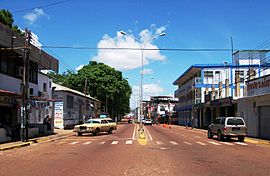
Orinoco Avenue in Puerto Ayacucho
|
||
|
||
| Country | ||
| State | Amazonas | |
| Municipality | Atures Municipality | |
| Founded | 1924 | |
| Area | ||
| • City | 281.02 sq mi (727.85 km2) | |
| Population
(2008)
|
||
| • Metro | 41,000 | |
| Time zone | UTC−4 (VET) | |
| Climate | Am | |
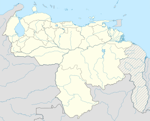
Puerto Ayacucho is the main city and capital of Amazonas State in Venezuela. It sits right across the Orinoco River from a village in Colombia called Casuarito.
The city was started to help move goods past the Atures Rapids on the Orinoco River. This happened in the late 1800s, mainly for rubber. Today, the city's economy relies on both local and international visitors. The Venezuelan army and navy also have bases here. The area has a tropical climate. Its surrounding rainforests are some of the most untouched places on Earth. Nearby mountains, called tepuis, hold unique small ecosystems that are still being explored.
Contents
History of Puerto Ayacucho
Puerto Ayacucho began to be built in 1924. This was thanks to Juan Vicente Gómez, who saw how important the region's resources were. The city was officially founded on December 9, 1928. It was named to remember the Battle of Ayacucho. Engineer Santiago Aguerrevere founded it.
Puerto Ayacucho took the place of San Fernando de Atabapo. San Fernando had been the main administrative center for the area. The city is built on a huge black granite rock. It faces the Colombian side of the river. Today, it is the most important town in Amazonas. It is also a river port that handles much of the area's business.
Early Buildings and Growth
The second "Simón Bolívar" Hospital opened on August 11, 1938. Governor Rafael Simón Urbina opened it. Father Alfredo Bonvecchio designed and directed its construction. Dr. López Rivas was the first government doctor to work there. He arrived in Puerto Ayacucho on October 26, 1937. The hospital was a big step for the growing city.
The oldest known map of Puerto Ayacucho was drawn in 1940. Ramón Ojeda Briceño, a pharmacist, made it. At that time, the city had about 120 houses. Between 600 and 700 people lived there. Most houses had palm roofs, dirt floors, and walls made of wattle and daub.
The city grew slowly until the 1960s. From the 1970s onwards, it grew much faster. This was mainly because people moved there from other parts of the Territory. Later, people also came from nearby states.
Geography and Nature
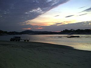
About 200 kilometers (124 miles) south of Puerto Ayacucho is the Casiquiare canal. This is a natural waterway that connects two of South America's biggest river systems. These are the Amazon and the Orinoco. Europeans first saw this canal in the 1600s. Naturalist Alexander von Humboldt explored it in 1800. He noted that the Aturès Indians, who gave their name to the Atures Rapids, had recently disappeared. Water from the Orinoco River flows into the Rio Negro through the Casiquiare. The Rio Negro is a branch of the Amazon. Many smaller rivers also add water along the way.
About 90 kilometers (56 miles) east of the city is Yutaje Falls. This is Venezuela's second-highest waterfall, dropping 670 meters (2,200 feet). The rainforest around the falls has some places for tourists to stay. There is also an airstrip. This area is home to many greenwing macaws, known as Ara chloroptera. You can also find jaguars, pink river dolphins, many types of monkeys, and other birds.
Most of the people living here are mestizo. This means they have mixed indigenous and Spanish backgrounds. There are also several local indigenous tribes. These include the Yanomami, Panare, Bari, Piaroa, and Guajibo (also called Jibis).
Climate
Puerto Ayacucho has a tropical monsoon climate. This means it has a wet season and a short dry season. The dry season runs from December to March.
| Month | Jan | Feb | Mar | Apr | May | Jun | Jul | Aug | Sep | Oct | Nov | Dec | Year |
|---|---|---|---|---|---|---|---|---|---|---|---|---|---|
| Record high °C (°F) | 38.8 (101.8) |
39.6 (103.3) |
40.2 (104.4) |
39.0 (102.2) |
38.6 (101.5) |
35.2 (95.4) |
35.0 (95.0) |
35.8 (96.4) |
36.4 (97.5) |
37.6 (99.7) |
36.8 (98.2) |
37.4 (99.3) |
40.2 (104.4) |
| Mean daily maximum °C (°F) | 34.4 (93.9) |
35.4 (95.7) |
35.5 (95.9) |
33.5 (92.3) |
31.5 (88.7) |
30.4 (86.7) |
30.3 (86.5) |
31.0 (87.8) |
31.9 (89.4) |
32.7 (90.9) |
33.2 (91.8) |
33.5 (92.3) |
32.8 (91.0) |
| Daily mean °C (°F) | 28.6 (83.5) |
29.3 (84.7) |
29.6 (85.3) |
28.6 (83.5) |
27.3 (81.1) |
26.5 (79.7) |
26.3 (79.3) |
26.7 (80.1) |
27.2 (81.0) |
27.7 (81.9) |
28.0 (82.4) |
28.1 (82.6) |
27.8 (82.0) |
| Mean daily minimum °C (°F) | 22.7 (72.9) |
23.2 (73.8) |
23.7 (74.7) |
23.6 (74.5) |
23.1 (73.6) |
22.6 (72.7) |
22.3 (72.1) |
22.4 (72.3) |
22.5 (72.5) |
22.7 (72.9) |
22.8 (73.0) |
22.7 (72.9) |
22.9 (73.2) |
| Record low °C (°F) | 17.8 (64.0) |
18.4 (65.1) |
18.3 (64.9) |
19.7 (67.5) |
17.2 (63.0) |
19.3 (66.7) |
18.1 (64.6) |
18.3 (64.9) |
18.3 (64.9) |
19.3 (66.7) |
19.9 (67.8) |
17.5 (63.5) |
17.2 (63.0) |
| Average rainfall mm (inches) | 31 (1.2) |
36 (1.4) |
74 (2.9) |
163 (6.4) |
311 (12.2) |
408 (16.1) |
398 (15.7) |
298 (11.7) |
198 (7.8) |
183 (7.2) |
127 (5.0) |
42 (1.7) |
2,269 (89.3) |
| Average rainy days (≥ 1.0 mm) | 2.8 | 2.9 | 5.1 | 11.3 | 18.2 | 22.3 | 22.4 | 19.5 | 14.8 | 13.9 | 9.4 | 5.0 | 147.6 |
| Average relative humidity (%) | 72.4 | 70.3 | 72.3 | 72.8 | 74.3 | 75.8 | 74.5 | 72.1 | 71.3 | 73.4 | 72.8 | 72.8 | 72.9 |
| Mean monthly sunshine hours | 275.9 | 252.0 | 248.0 | 177.0 | 151.9 | 129.0 | 145.7 | 155.0 | 168.0 | 201.5 | 222.0 | 260.4 | 2,386.4 |
| Source 1: Instituto Nacional de Meteorología e Hidrología (INAMEH) | |||||||||||||
| Source 2: NOAA (extremes, precipitation, and sun) | |||||||||||||
Getting Around Puerto Ayacucho
Two main national highways connect Puerto Ayacucho to the rest of Venezuela. The first is Troncal 12, which goes through Caicara del Orinoco. The second is Troncal 2, which passes through San Fernando de Apure. This road meets Troncal 12 near Puerto Páez.
The city has a national airport called Cacique Aramare Airport. It is located south of the city. Currently, the national airline Conviasa offers commercial flights. They have one daily flight from Simón Bolívar International Airport (Maiquetía). Local flights also leave from Cacique Aramare Airport. These flights go to other towns in the state. Some destinations include San Juan de Manapiare, Maroa, San Fernando de Atabapo, San Carlos de Río Negro, and La Esmeralda.
Fun Places to Visit
Puerto Ayacucho has many interesting places for visitors to explore:
- Tobogán de la Selva: This is a huge rock slab where water flows. It forms a natural water slide that ends in a cool pool.
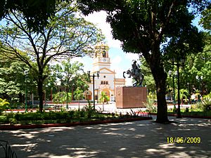
- Rómulo Betancourt Square: People often call this the "Plaza de Los Indios" (Indians' Square). It's a place where local indigenous people sell their handmade crafts.
- Ethnological Museum of Amazonas "Monsignor Enzo Ceccarelli": This museum tells the detailed history of the region. It covers everything from when missionaries first arrived until today.
- Cathedral "Maria Auxiliadora": Built in 1952, this cathedral has a very large oil painting of Christ inside.
- Indigenous Market: A vibrant market where you can experience local culture and find unique items.
- Bolivar Square: A central public square, often a gathering place.
- Cold Mountain: A natural area that offers a cooler escape.
- Tourist center "La Perla Negra": A popular spot for visitors.
- Raudales de Atures and Maipures: These are rapids on the river, offering scenic views.
- The viewpoint of Monte Bello: A great spot to see panoramic views of the area.
- Spas: These include natural pools like Pozo Azul, Pozo Cristal, Los Márquez, and Las Tinajas.
See also
 In Spanish: Puerto Ayacucho para niños
 | Kyle Baker |
 | Joseph Yoakum |
 | Laura Wheeler Waring |
 | Henry Ossawa Tanner |


