Puerto Barrios facts for kids
Quick facts for kids
Puerto Barrios
|
|||
|---|---|---|---|

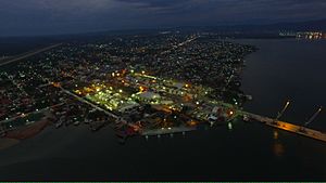
Puerto Barrios at night
|
|||
|
|||
| Country | |||
| Department | |||
| Area | |||
| • Municipality | 1,190 km2 (460 sq mi) | ||
| Elevation | 638 m (2,093 ft) | ||
| Highest elevation | 1,276 m (4,186 ft) | ||
| Lowest elevation | 0 m (0 ft) | ||
| Population
(2018)
|
|||
| • Municipality | 100,593 | ||
| • Density | 84.5/km2 (218.9/sq mi) | ||
| • Urban | 100,593 | ||
| Climate | Af | ||
Puerto Barrios is a lively city in Guatemala. It sits on the Gulf of Honduras and the Bahia de Amatique. This city is the main center for the Izabal Department.
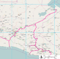
It is Guatemala's most important port on the Caribbean Sea. There is also a newer port nearby called Santo Tomás de Castilla. In 2018, about 100,593 people lived in Puerto Barrios. The city is about 297 kilometers (185 miles) northeast of Guatemala City. It is the end point of Highway CA9, which crosses the country.
The people in Puerto Barrios come from many different backgrounds. Most are Garifuna, Maya, and Afro-Caribbean groups. The city was very important in the late 1800s and early 1900s. This was after a railroad was built to connect banana and coffee farms to the port. The United Fruit Company controlled these operations.
Puerto Barrios has many neighborhoods, like El Rastro and La Veinte. Even though it is a small town, many ship workers visit. They enjoy the entertainment spots around the city.
More visitors are coming to Puerto Barrios now. This is because the nearby town of Santo Tomás de Castilla welcomes cruise ships. The Puerto Barrios Airport has also been updated. It now has regular flights.
There are many fun places to visit nearby. You can explore the ancient Mayan ruins of Quirigua. The United Fruit Company bought Quiriguá in 1910 for banana farms. But they saved 75 acres (30 hectares) around the ruins as an archaeological park. This kept a piece of jungle safe among the plantations.
Near Quirigua, you can find the Quirigua Hospital. The United Fruit Company built it in 1910. It was known as one of the best tropical hospitals in the Americas. There is also a cemetery there where some workers were buried.
Another cool spot is the Castillo de San Felipe de Lara. This is an old Spanish fort in Río Dulce. It guards the entrance to Lake Izabal. You can also visit Livingston. This town is famous for its Garifuna culture. You might see exciting Punta and Yankunu dances there.
Contents
Exploring Puerto Barrios
A Look at the City's Past
In 1883, President Justo Rufino Barrios wanted to build a railroad. This railroad would connect Guatemala City to a port on the Atlantic coast. It would help move coffee from his farms and those of his friends. He asked people to help pay for it.
However, President Barrios died in 1885 during the Battle of Chalchuapa. His plan for the railroad was then forgotten for a while.
The railroad project started again in 1892. This was when José María Reina Barrios became president. On July 19, 1895, he ordered that a new city be built. This city would be called Puerto Barrios. The city was officially founded on December 5, 1892. President Reina Barrios also declared Puerto Barrios a "Major port of the Republic." He moved the customs offices there from Livingston.
President Reina Barrios also planned a big event called the Exposición Centroamericana (Central American Expo) for 1897. He wanted the Northern Railroad to be finished quickly for this event. The railroad was important for moving goods and people between the Caribbean Sea and the Pacific Ocean. He hoped the railroad would help Guatemala grow.
However, the price of coffee and silver dropped. Also, building the railroad near Guatemala City was very hard. The land had steep cliffs and mountains. This caused Guatemala's economy to struggle. President Reina Barrios was assassinated in 1898.
After Reina Barrios' death, Manuel Estrada Cabrera became president. Guatemala owed a lot of money to British banks. So, he looked for help from the United States. In 1900, he allowed an American company to finish the railroad. This company could use the railroad and its facilities for free. This included the port and dock in Puerto Barrios. Guatemalans had to pay to use their own port.
In 1904, the International Railways of Central America (IRCA) was formed. This company was owned by Minor Keith's partners. The harbor was partly built by Theodore Roosevelt's engineers. Eventually, the United Fruit Company, which owned IRCA, controlled Puerto Barrios completely. They owned the docks, the railroads, and the banana farms. They even owned the ships, called the Great White Fleet.
This continued until the 1950s. President Jacobo Árbenz Guzmán (1951-1954) wanted to change things. He decided to build a new highway and another port, Santo Tomas de Castilla. This was to compete with the American fruit company. He also made land reforms that affected the company. Árbenz was removed from power in 1954. But the highway was almost finished and was completed by the next president. The IRCA company stopped making a profit in 1957.
A big earthquake hit Guatemala on February 4, 1976. It destroyed most of the port in Puerto Barrios. Most of the cargo ships then moved to the new port in Santo Tomás de Castilla. Today, Puerto Barrios is still an important place for fruit companies like Dole, Fresh Del Monte Produce, and Chiquita.
Where is Puerto Barrios?
The land in Puerto Barrios changes a lot. It goes from sea level at Punta de Manabique to 1,276 meters (4,186 feet) high at Cerro San Gil. The main part of the city is on the shore of Santo Tomás bay. This bay is part of Amatique Bay. There is a small piece of land called Punta de Manabique. It separates the bay from the Gulf of Honduras and protects it from storms.
 |
Caribbean Sea, Atlantic Ocean |  |
||
| Livingston, Izabal Department municipality | Honduras | |||
| Morales, Izabal Department municipality Honduras |
Puerto Barrios Climate
Puerto Barrios has a tropical rainforest climate. This means it gets a lot of rain all year round. There is no dry season here. The average temperature in Puerto Barrios is about 27.3°C (81.1°F). About 2,748 millimeters (108.2 inches) of rain falls each year.
| Climate data for Puerto Barrios (Puerto Barrios Airport) (1991–2020) | |||||||||||||
|---|---|---|---|---|---|---|---|---|---|---|---|---|---|
| Month | Jan | Feb | Mar | Apr | May | Jun | Jul | Aug | Sep | Oct | Nov | Dec | Year |
| Record high °C (°F) | 36.0 (96.8) |
36.0 (96.8) |
39.0 (102.2) |
40.4 (104.7) |
41.0 (105.8) |
39.0 (102.2) |
36.4 (97.5) |
36.4 (97.5) |
36.4 (97.5) |
37.8 (100.0) |
35.2 (95.4) |
35.0 (95.0) |
41.0 (105.8) |
| Mean daily maximum °C (°F) | 27.4 (81.3) |
28.6 (83.5) |
30.0 (86.0) |
31.6 (88.9) |
32.1 (89.8) |
32.1 (89.8) |
31.4 (88.5) |
31.6 (88.9) |
31.8 (89.2) |
30.6 (87.1) |
28.6 (83.5) |
27.6 (81.7) |
30.3 (86.5) |
| Daily mean °C (°F) | 23.7 (74.7) |
24.7 (76.5) |
25.8 (78.4) |
27.7 (81.9) |
28.4 (83.1) |
28.6 (83.5) |
28.0 (82.4) |
28.1 (82.6) |
28.1 (82.6) |
27.0 (80.6) |
25.0 (77.0) |
24.1 (75.4) |
26.6 (79.9) |
| Mean daily minimum °C (°F) | 20.2 (68.4) |
20.6 (69.1) |
21.1 (70.0) |
22.3 (72.1) |
23.0 (73.4) |
23.3 (73.9) |
22.9 (73.2) |
23.0 (73.4) |
23.0 (73.4) |
22.6 (72.7) |
21.4 (70.5) |
20.6 (69.1) |
22.0 (71.6) |
| Record low °C (°F) | 14.7 (58.5) |
15.1 (59.2) |
15.1 (59.2) |
16.4 (61.5) |
17.5 (63.5) |
19.8 (67.6) |
20.2 (68.4) |
19.5 (67.1) |
18.4 (65.1) |
19.2 (66.6) |
16.9 (62.4) |
15.4 (59.7) |
14.7 (58.5) |
| Average precipitation mm (inches) | 294.6 (11.60) |
185.5 (7.30) |
160.8 (6.33) |
139.3 (5.48) |
207.6 (8.17) |
248.7 (9.79) |
408.7 (16.09) |
384.7 (15.15) |
325.2 (12.80) |
371.8 (14.64) |
404.9 (15.94) |
269.5 (10.61) |
3,401.3 (133.91) |
| Average precipitation days (≥ 1.0 mm) | 14.7 | 12.5 | 10.6 | 7.9 | 11.9 | 15.9 | 22.0 | 20.5 | 16.8 | 16.7 | 17.1 | 16.5 | 183.1 |
| Source: NOAA | |||||||||||||
Getting Around: Transport and Ports
Building the Atlantic Highway and Santo Tomas de Castilla Harbor
President Jacobo Árbenz wanted Guatemala to be more independent. He aimed to reduce the country's reliance on the United States. He also wanted to break the control of American companies. So, his government started building the Atlantic Highway. This highway was meant to compete with the United Fruit Company's railroad. The company, through its branch called International Railways of Central America (IRCA), had controlled land transport since 1904.
The Ministry of Communications started building the highway. They worked with the military engineering team. The plan was to build the highway next to the railway line. Building a new port was also important. This would break another monopoly by the United Fruit Company. Their company, The Great White Fleet, owned and ran Puerto Barrios.
Puerto Barrios in Movies
The New Adventures of Tarzan (1935)
In 1935, the movie The New Adventures of Tarzan was filmed in Guatemala. The United Fruit Company and President Jorge Ubico helped with the filming. Here are some of the places where they filmed:
- Chichicastenango: Used for scenes of a local village.
- Antigua Guatemala: The Green Goddess temple scenes.
- Río Dulce: River scenes.
- Puerto Barrios: Where the explorers arrived and left by boat.
- Tikal: Jungle scenes.
- Quiriguá: A Mayan city where they learned about the maya civilization.
- Guatemala City: The fancy Palace Hotel was used for scenes of a hotel in a made-up town.
Modern Developments in Puerto Barrios
Torre Manatí Skyscraper Project
In 2018, a company called Desarrollos Inmobiliarios Izabal, S.A. started a big project. They hired a Guatemalan architecture firm, Studio Domus. The plan was to build a 37-story skyscraper and a yacht club in Puerto Barrios. This project is expected to cost 15 million dollars.
Construction began in May 2019. It is planned to be finished in January 2021. When it is done, Torre Manatí will be the tallest skyscraper in Central America.
Famous People from Puerto Barrios
- David Campos, elected to the San Francisco Board of Supervisors in November 2008.
- Freddy Thompson, a soccer player.
- David M Stokes, a soccer player who played in the 1968 Olympics.
|
See also
 In Spanish: Puerto Barrios para niños
 | Jackie Robinson |
 | Jack Johnson |
 | Althea Gibson |
 | Arthur Ashe |
 | Muhammad Ali |


