
Putrajaya facts for kids
Quick facts for kids
Putrajaya
Prang Besar
|
|||
|---|---|---|---|
| Federal Territory of Putrajaya Wilayah Persekutuan Putrajaya |
|||
| Other transcription(s) | |||
| • Jawi | ڤوتراجاي | ||
| • Chinese | 布城 (Simplified) 布城 (Traditional) Bùchéng (Hanyu Pinyin) |
||
| • Tamil | புத்ராஜெயா Putrājāyā (Transliteration) |
||
|
From top, left to right:
Perdana Putra housing the office of Malaysia's Prime Minister, the Putra Mosque, the Putrajaya Corporation Complex, the Tuanku Mizan Zainal Abidin Mosque, the PICC, Seri Wawasan Bridge, High-rise ministry complexes, and Aerial view of Putrajaya |
|||
|
|||
| Motto(s):
"Bandar raya Taman, Bandar raya Bestari"
("Garden City, Intelligent City") |
|||
.svg)
|
|||
| Country | |||
| First settled | c. 1921 | ||
| Planned city established | 19 October 1995 | ||
| Transferred from Selangor to federal jurisdiction | 1 February 2001 | ||
| Government | |||
| • Type | Direct federal administration | ||
| Area | |||
| • Total | 49 km2 (19 sq mi) | ||
| Population
(Q1 2024)
|
|||
| • Total | 119,700 | ||
| • Density | 2,443/km2 (6,330/sq mi) | ||
| Human Development Index | |||
| • HDI (2022) | 0.886 (very high) (2nd) | ||
| Time zone | UTC+8 (MST) | ||
| Postcode |
62xxx
|
||
| Calling code | +603-88 | ||
| ISO 3166 code | MY-16 | ||
| Mean solar time | UTC+06:46:40 | ||
| Vehicle registration | F and Putrajaya | ||
| Rapid Transit | |||


Putrajaya is the special administrative center of Malaysia. It is also known as the Federal Territory of Putrajaya. The main government offices of Malaysia moved here in 1999. This happened because the old capital, Kuala Lumpur, became too crowded. The country's courts also moved to Putrajaya in 2003.
Kuala Lumpur is still Malaysia's official capital city. It is where the head of state, the Yang di-Pertuan Agong, and the national parliament are located. Kuala Lumpur also remains the country's main business and financial hub.
The idea for Putrajaya came from Prime Minister Mahathir Mohamad in the 1990s. He wanted a new city that would use modern technology for government work. Building Putrajaya started in 1995 and cost about US$8.1 billion. In 2001, Putrajaya became Malaysia's third federal territory. It is also part of MSC Malaysia, a special area for technology and digital communication.
Contents
What's in a Name?
Putrajaya was named after Malaysia's first Prime Minister, Tunku Abdul Rahman Putra Al-Haj. The name comes from the ancient Sanskrit language.
- "Putra" means "son" or "people."
- "Jaya" means "success" or "victory."
So, Putrajaya means "victorious people." This name was chosen in 1994.
How Putrajaya Was Created

The area where Putrajaya now stands was once a jungle. It was first settled in 1921 as a rubber plantation called Prang Besar. This name means "Great War" in Malay. British soldiers from World War I started the plantation.
Over time, the plantation grew much larger. It joined with other nearby estates. Until 1975, this area was part of the Hulu Langat District.
Planning a New Capital
In the late 1980s, Prime Minister Mahathir Mohamad had a vision. He wanted a new administrative center for the federal government. Kuala Lumpur was getting too busy. Government offices were spread out and caused traffic jams.
The new city was planned to be between Kuala Lumpur and the new Kuala Lumpur International Airport (KLIA). Two places were considered, and Prang Besar was chosen. The name Putrajaya was then picked for this new site.
Becoming a Federal Territory
The federal government worked with the state of Selangor to create this new federal territory. In the mid-1990s, the government bought a large piece of land in Prang Besar from Selangor. Now, Selangor surrounds two federal territories: Kuala Lumpur and Putrajaya.

Putrajaya was designed to be a "garden city" and a "smart city." About 38% of the city is green spaces. These areas make the natural landscape even more beautiful. The city plan includes many open spaces and wide roads.
Construction started in August 1995. It was Malaysia's biggest project at the time. The entire city was designed and built by Malaysian companies. Only a small amount of materials were brought in from other countries.
The 1997 Asian financial crisis slowed down the building process a bit. In 1999, 300 staff members from the Prime Minister's office moved to Putrajaya. By 2005, most government workers had moved there. On February 1, 2001, Putrajaya officially became Malaysia's third federal territory.
In 2002, a train line called KLIA Transit opened. It connects Putrajaya to the KLIA airport. There were plans for a monorail system in Putrajaya, but it was stopped because it was too expensive. One of the monorail bridges is still unused today.
Who Lives in Putrajaya?
| Historical population | ||
|---|---|---|
| Year | Pop. | ±% |
| 2010 | 68,361 | — |
| 2015 | 88,300 | +29.2% |
| 2020 | 109,202 | +23.7% |
| Source: | ||
| Ethnic groups in Putrajaya - 2020 Census | ||||
|---|---|---|---|---|
| ethnic groups | percent | |||
| Bumiputera | 97.9% | |||
| Indian | 1.2% | |||
| Chinese | 0.6% | |||
| Others | 0.2% | |||
In 2007, about 30,000 people lived in Putrajaya. Most of them were government workers. The government encouraged its employees to move to the city. They offered help like subsidies and loans.
By 2015, the population grew to 88,300 people. As of early 2024, Putrajaya has an estimated population of 119,700.
Religions in Putrajaya
| Religion in Putrajaya - 2020 Census | ||||
|---|---|---|---|---|
| religion | percent | |||
| Islam | 97.2% | |||
| Hinduism | 1.1% | |||
| Christianity | 0.8% | |||
| Buddhism | 0.5% | |||
| Unknown / None | 0.4% | |||
| Others | 0.1% | |||
According to the 2020 census, most people in Putrajaya are Muslim (97.2%). Other religions include Hinduism (1.1%), Christianity (0.8%), and Buddhism (0.5%).
What to See and Do
Most buildings in Putrajaya have Middle Eastern architectural designs. This style shows Malaysia's Islamic identity.
Important Places and Buildings
- Alamanda Putrajaya Shopping Centre (the only mall in Putrajaya)
- Heritage Square
- Putrajaya Corporation Square
- Selera Putra
- Souq Putrajaya
- Pusat Kejiranan Presint 9 and Presint 16 (Community Centers)
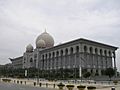
- Putra Mosque
- Tuanku Mizan Zainal Abidin Mosque
- PUSPANITAPURI (a welfare association building)
Monuments and Landmarks
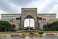
- Putrajaya Landmark
- Millennium Monument
- National Heroes Square
Parks and Green Spaces
- Putrajaya Lake
- Putra Square
- Putrajaya Wetlands Park
- Taman Selatan
- Putrajaya Botanical Gardens (the largest botanical garden in Malaysia, covering 92 hectares)
- Saujana Hijau Park, Precinct 11
Schools and Universities
Putrajaya has many schools for children of all ages.
- Kindergarten and Pre-School: Brainy Bunch International Montessori
- Primary Schools: Many "SK Putrajaya Presint" schools (e.g., SK Putrajaya Presint 5 (1))
- Secondary Schools: Many "SMK Putrajaya Presint" schools (e.g., SMK Putrajaya Presint 8 (1))
- Special Schools:
* Sekolah Sultan Alam Shah (a fully residential school) * Sekolah Menengah Kebangsaan Agama Putrajaya (SMAPUTRA)
- Universities: Heriot-Watt University Malaysia
- International Schools:
* Nexus International School * The International Modern Arabic School
Getting Around Putrajaya
Roads and Highways
Putrajaya is well-connected by major highways. These include Federal Highway 29 and 30. The South Klang Valley Expressway (E26) and ELITE (E6) also pass nearby. Highway 29 connects to the Damansara–Puchong Expressway (LDP) (E11). This links Putrajaya to other cities like Puchong and Subang Jaya.
Inside Putrajaya, there are several main roads:
- Persiaran Persekutuan
- Persiaran Sultan Salahuddin Abdul Aziz Shah (This road has the world's largest roundabout, 3.5 km wide!)
- Persiaran Utara
- Lebuh Sentosa
- Persiaran Barat
- Persiaran Selatan
- Persiaran Timur
- Persiaran Perdana (Boulevard)
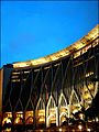
Famous Bridges

Putrajaya is known for its many beautiful bridges. Some of them are:
- Seri Perdana Bridge
- Putra Bridge
- Seri Wawasan Bridge
- Seri Bakti Bridge
- Seri Saujana Bridge
- Seri Bestari Bridge
- Seri Setia Bridge
- Seri Gemilang Bridge
Public Transportation
Trains
Putrajaya has two train lines: the line and the line. Both lines meet at the Putrajaya Sentral station. This station is a major transport hub.
The MRT Putrajaya Line is Malaysia's fifth metro line. It is the longest line in the Rapid Rail network. Putrajaya Sentral is its southernmost station. The KLIA Transit is a train that connects KL Sentral in Kuala Lumpur to the Kuala Lumpur International Airport. It stops at Putrajaya along the way.
There were plans for a monorail in Putrajaya around 2003. However, these plans were stopped because there weren't enough people living in the city yet.
Buses
The Putrajaya Corporation runs its own bus service called Nadi Putra. These buses use natural gas and some are electric. They serve all of Putrajaya and nearby Cyberjaya. There are also express buses to Kuala Lumpur and other nearby cities. You can catch these buses from Putrajaya Sentral and P&R Presint 14.
Other bus companies like Rapid KL and Causeway Link also offer services from Putrajaya Sentral. These buses can take you to places like Banting, Puchong, and Petaling Jaya.
Global Connections
Putrajaya has special partnerships with other cities around the world. These are called "twin towns" or "sister cities."
 Cyberjaya, Malaysia
 Astana, Kazakhstan
 Sejong City, South Korea
Putrajaya's Climate
Putrajaya has a tropical rainforest climate. This means it has heavy rainfall and high temperatures all year round. There isn't a true dry season. The average temperature is around 27.1 °C (80.8 °F). The city gets about 2307 mm (90.8 inches) of rain each year.
| Climate data for Putrajaya | |||||||||||||
|---|---|---|---|---|---|---|---|---|---|---|---|---|---|
| Month | Jan | Feb | Mar | Apr | May | Jun | Jul | Aug | Sep | Oct | Nov | Dec | Year |
| Mean daily maximum °C (°F) | 31.1 (88.0) |
31.9 (89.4) |
32.4 (90.3) |
32.2 (90.0) |
32.0 (89.6) |
31.7 (89.1) |
31.4 (88.5) |
31.3 (88.3) |
31.3 (88.3) |
31.2 (88.2) |
31.1 (88.0) |
31.0 (87.8) |
31.6 (88.8) |
| Daily mean °C (°F) | 26.5 (79.7) |
27.1 (80.8) |
27.4 (81.3) |
27.6 (81.7) |
27.7 (81.9) |
27.4 (81.3) |
27.0 (80.6) |
27.0 (80.6) |
26.9 (80.4) |
26.9 (80.4) |
26.9 (80.4) |
26.7 (80.1) |
27.1 (80.8) |
| Mean daily minimum °C (°F) | 22.0 (71.6) |
22.3 (72.1) |
22.5 (72.5) |
23.1 (73.6) |
23.4 (74.1) |
23.1 (73.6) |
22.6 (72.7) |
22.8 (73.0) |
22.6 (72.7) |
22.7 (72.9) |
22.8 (73.0) |
22.4 (72.3) |
22.7 (72.8) |
| Average precipitation mm (inches) | 168 (6.6) |
150 (5.9) |
227 (8.9) |
250 (9.8) |
188 (7.4) |
118 (4.6) |
121 (4.8) |
154 (6.1) |
176 (6.9) |
254 (10.0) |
268 (10.6) |
233 (9.2) |
2,307 (90.8) |
| Source: Climate-Data.org | |||||||||||||
Images for kids
-
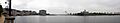
Panoramic image of Putrajaya, showing the Putra Bridge, the Ministry of Finance, the Seri Wawasan Bridge, and the Istana Darul Ehsan.
-
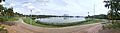
Panorama of Putrajaya from Cyberjaya Lake Gardens in December 2023.
-
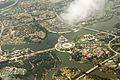
Aerial Photograph - Oct 2013
-
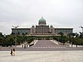
The Prime Minister's office at Perdana Putra
-
Perbadanan Putrajaya (Putrajaya Corporation) government complex
-
The Ministry of Finance complex
-
Istana Kehakiman (Palace of Justice courthouse)
-
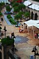
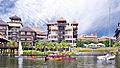
Putrajaya Walk
-
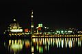
PM Office and Putra Mosque at night
-
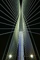
Interior view of the Seri Wawasan Bridge
-
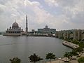
Putra Mosque with the Prime Minister's office in the background
-
Seri Saujana Bridge at night
-
Pullman Putrajaya Lakeside Hotel (now, DoubleTree by Hilton Putrajaya Lakeside)
-
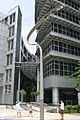
Modern architecture includes streetlamps
-
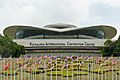
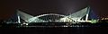
Putrajaya International Convention Centre (PICC)
-
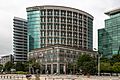
Ministry of Health Building
-
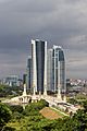
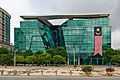
Highrises in Precinct 4
-
Ministry of Agriculture and Agro Based Industry Building


See also
 In Spanish: Putrajaya para niños
