
Pyramid Peak (Whatcom County, Washington) facts for kids
Quick facts for kids Pyramid Peak |
|
|---|---|

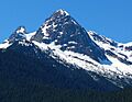
Pyramid Peak seen from Diablo Lake Overlook
|
|
| Highest point | |
| Elevation | 7,182 ft (2,189 m) |
| Prominence | 142 ft (43 m) |
| Parent peak | Pinnacle Peak 7,360+ ft |
| Geography | |

Pyramid Peak
Location in Washington (state)

Pyramid Peak
Location in the United States
|
|
| Parent range | North Cascades |
| Topo map | USGS Diablo Dam |
| Climbing | |
| First ascent | 1931, William Degenhardt and Herbert Strandberg |
| Easiest route | Scramble (class 3) |
Pyramid Peak is a mountain in the North Cascades mountain range in Washington, United States. It stands tall at 7,182-foot (2,189-metre) (about 2,189 meters) above sea level. This impressive peak is found inside the beautiful North Cascades National Park.
Pyramid Peak rises steeply from Diablo Lake, which is a large reservoir on the Skagit River. It's part of a group of peaks that stretch south towards other popular climbing spots like Colonial Peak and Snowfield Peak. Even though it's not the tallest peak, Pyramid Peak is famous for how dramatically it rises from the land around it. Rain and melting snow from the mountain flow into Diablo Lake and then into the Skagit River.
The first people to climb Pyramid Peak were William Degenhardt and Herbert Strandberg in 1931. They were members of a climbing group called the Seattle Mountaineers. To reach the peak, climbers usually follow the Pyramid Lake Trail. This trail starts near the Diablo Dam on the North Cascades Highway. From the lake, climbers find their way up Pyramid Arm and towards the Colonial Glacier.
Understanding the Climate

Pyramid Peak is located in a "marine west coast" climate zone. This means it gets a lot of influence from the Pacific Ocean. Most of the weather systems, like big clouds and storms, start over the Pacific Ocean. They then travel northeast towards the Cascade Mountains.
When these weather systems hit the tall peaks of the Cascade Range, they are forced to rise. As the air goes higher, it cools down and drops its moisture. This process is called "orographic lift," and it causes a lot of rain or snow to fall on the mountains. The western side of the North Cascades, where Pyramid Peak is, gets a lot of precipitation, especially in winter.
During the winter, the weather is often cloudy and snowy. However, in the summer, high-pressure systems over the Pacific Ocean usually bring clear skies. Because of the ocean's influence, the snow here can be wet and heavy. This type of snow can increase the risk of avalanches, which are dangerous slides of snow down a mountain.
How the Mountains Formed
The North Cascades mountains have some of the most rugged and dramatic landscapes. You can see jagged peaks, tall spires, sharp ridges, and deep valleys carved by glaciers. The amazing shapes of these mountains and the big changes in elevation were created by geological events that happened millions of years ago. These events also led to the different climates we see across the Cascade Range.
The story of how the Cascade Mountains formed began millions of years ago, during a time called the late Eocene Epoch. At that time, huge pieces of the Earth's outer layer, called tectonic plates, were moving. The North American Plate was slowly sliding over the Pacific Plate. This movement caused many volcanoes to erupt, creating new rock.
Also, small pieces of land, called terranes, joined together to form the North Cascades about 50 million years ago. These terranes were like puzzle pieces that came together to build the mountain range.
Later, during the Pleistocene period, which was over two million years ago, huge sheets of ice called glaciers moved across the land. These glaciers carved out the landscape, leaving behind deposits of rock and debris. The "U"-shaped valleys you see in the mountains today were formed by these powerful glaciers. The combination of the land pushing upwards and cracking (called uplift and faulting) along with the glaciers has created the tall peaks and deep valleys of the North Cascades area.
Images for kids
-
Pyramid Peak seen from Diablo Lake Overlook
-
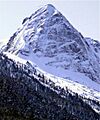
Pyramid Peak covered in snow.
