Qilian Mountains facts for kids
Quick facts for kids Qilian Mountains |
|
|---|---|
| 祁連山 | |

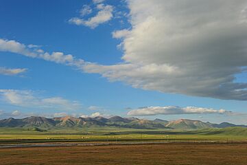
Qilian Mountains in Qilian County, Qinghai
|
|
| Highest point | |
| Peak | Kangze'gyai |
| Elevation | 5,808 m (19,055 ft) |
| Geography | |
| Location | Gansu and Qinghai provinces, China |
The Qilian Mountains (simplified Chinese: 祁连山; traditional Chinese: 祁連山; pinyin: Qílián Shān), also called Tsilien, are a large mountain range in northern China. They are sometimes known as the Nan Shan, which means "Southern Mountains." This is because they are south of the important Hexi Corridor.
These mountains are part of the bigger Kunlun Mountains system. They form a natural border between the Qinghai and Gansu provinces.
Contents
Exploring the Qilian Mountains' Geography
Where are the Qilian Mountains Located?
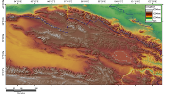
The Qilian Mountains stretch for about 800 kilometers (500 miles). They start south of Dunhuang and go southeast. These mountains form the edge of the Tibetan Plateau to the northeast. They also create the southwestern border of the Hexi Corridor.
Tall Peaks of the Qilian Range
The main Qilian Shan peak is about 60 kilometers (37 miles) south of Jiuquan. It stands tall at 5,547 meters (18,199 feet). However, there are two even higher peaks further south. Kangze'gyai is the tallest at 5,808 meters (19,055 feet). Another high peak is Qaidam Shan, reaching 5,759 meters (18,894 feet). Gangshiqia Peak is another important mountain in the eastern part of the range.
Connecting Mountain Ranges
To the west, the Nan-Shan range continues as Yema Shan (5,250 meters / 17,224 feet). It also connects to the Altun Shan (Altyn Tagh) (5,798 meters / 19,022 feet). Eastward, the range passes north of Qinghai Lake. It ends near Lanzhou with Daban Shan and Xinglong Shan. Maoma Shan peak (4,070 meters / 13,353 feet) is an eastern part of the range. Parts of the Ming dynasty's Great Wall were built along the northern slopes of these mountains.
Rivers and Glaciers of Qilian
The Qilian Mountains are a source for many rivers and streams. Most of these flow northeast into the Hexi Corridor. They provide water for farming in the communities there. Eventually, these rivers disappear into the Alashan Desert. The Ejin (Heihe) River is one of the most famous.
The region also has many glaciers, which are huge bodies of ice. The largest is the Touming Mengke glacier. Sadly, these glaciers have been melting faster in recent years.
Unique Features and Ecosystems
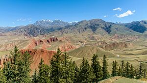
Lake Hala is a large salty lake found within the Qilian Mountains. The unique natural environment of the Qilian Mountains is known as the Qilian Mountains conifer forests. This means it has many evergreen trees like pines and firs.
Biandukou (扁都口) is a mountain pass in the Qilian Mountains. It is over 3,500 meters (11,483 feet) high. This pass connects Minle County in Gansu to Qilian County in Qinghai.
History of the Qilian Mountains
The ancient Chinese book Shiji mentions the "Qilian mountains." It talks about them in connection with the homeland of the Yuezhi people. Some historians think these "Qilian Mountains" might actually have been the Tian Shan mountains, which are much further west.
The name Qilian (祁连) is thought to be an old word from the Xiongnu people. It means "sky" (Chinese: 天). This meaning was explained by Yan Shigu, a writer from the Tang dynasty.
The Tuyuhun people also lived around the Qilian Mountains long ago.
For a time, the mountain range was called the Richthofen Range by Europeans. This was named after Ferdinand von Richthofen, a famous explorer and geologist. He was the uncle of the well-known pilot, the Red Baron.
Today, the mountains give their name to Qilian County in Qinghai province.
 | Valerie Thomas |
 | Frederick McKinley Jones |
 | George Edward Alcorn Jr. |
 | Thomas Mensah |


