Queensbury, New York facts for kids
Quick facts for kids
Queensbury
|
|
|---|---|

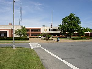
Warren County Municipal Center
|
|
| Motto(s):
Home of Natural Beauty ... A Good Place to Live
|
|

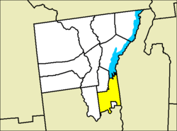
Location of Queensbury within Warren County
|
|
| Country | United States |
| State | New York |
| County | Warren |
| Established | 1786 |
| Named for | Charlotte of Mecklenburg-Strelitz |
| Seat | Queensbury Town Center |
| Area | |
| • Total | 64.84 sq mi (167.93 km2) |
| • Land | 62.83 sq mi (162.73 km2) |
| • Water | 2.01 sq mi (5.20 km2) 2.78% |
| Elevation | 502 ft (153 m) |
| Population
(2020)
|
|
| • Total | 29,169 |
| • Density | 449.86/sq mi (173.697/km2) |
| Time zone | UTC-5 (EST) |
| • Summer (DST) | UTC-4 (EDT) |
| ZIP code |
12804
|
| Area code(s) | 518 |
| Official butterfly | Karner Blue |
| Website | https://www.queensbury.net |
Queensbury is a town located in Warren County, New York, in the United States. In 2020, about 29,169 people lived there.
Queensbury is home to the main government offices for Warren County. These offices moved to Queensbury in 1963 from the nearby village of Lake George. The town is in the southeastern part of Warren County. It is also part of the larger Glens Falls Metropolitan Statistical Area. Queensbury was named after Queen Charlotte. The town mostly lies north of the city of Glens Falls, but it actually surrounds the city on three sides.
You can find fun places like Six Flags Great Escape and Hurricane Harbor, a big theme park, in northwest Queensbury. Also, West Mountain, a place for downhill skiing, is in the southwestern part of the town.
Contents
Exploring the History of Queensbury
The story of Queensbury began in 1762 with something called the Queensbury Patent. This was a special land grant from the British King. It was meant to encourage people to move to this area. The area was near the Adirondack Mountains, Lake George, and the Hudson River.
Early Settlers and the Revolutionary War
The land grant was named after Queen Charlotte, the wife of King George III. In 1763, Quaker families started moving to Queensbury. They cleared land and built farms. However, their peaceful lives changed in 1777 because of the American Revolutionary War. Quakers believe in peace, so they left Queensbury during the war. The area was mostly empty until the war ended. In 1783, the Quakers came back and continued building their community.
Growing as a Town and Boundary Changes
In 1786, Queensbury officially became a town. At first, it included all of what is now Warren County. But over time, parts of Queensbury became new towns. In 1792, the town of Fairfield (now Lake Luzerne) was formed. In 1810, part of Queensbury became the town of Caldwell (now Lake George).
In 1908, Glens Falls, which was the biggest village in Queensbury, became its own city. This meant it was no longer part of the town. Since 1980, more people have lived in Queensbury than in Glens Falls.
Recent Land Changes
In 2003, Glens Falls took over about 49 acres (0.20 km²) of land from Queensbury. This land was empty and known as Veterans Field. It helped Glens Falls connect to other areas. Both the city and the town now share ownership of a small part of Sherman Avenue because of this change.
Two historic homes, the Sanford House and the Asa Stower House, are recognized on the National Register of Historic Places.
Understanding Queensbury's Geography
Queensbury covers about 64.81 square miles (167.85 km²). Most of this area, about 63.01 square miles (163.19 km²), is land. The rest, about 1.80 square miles (4.66 km²), is water. The town is located in the southeastern part of the Adirondack Mountains.
Where Queensbury is Located
To the west, Queensbury borders the town of Lake Luzerne. The southern border is next to the city of Glens Falls and the Hudson River. Across the Hudson River is Saratoga County. To the east, Queensbury borders Washington County.
The northern border is next to the town of Lake George. The town and Warren County say the border follows the shoreline of Lake George itself. However, some maps show that the northern border includes a small part of the lake, including Speaker Heck Island.
Some areas in western and northern Queensbury are inside the Adirondack Park. This park is a large protected area.
Queensbury's Population and People
| Historical population | |||
|---|---|---|---|
| Census | Pop. | %± | |
| 1820 | 2,433 | — | |
| 1830 | 3,080 | 26.6% | |
| 1840 | 3,789 | 23.0% | |
| 1850 | 2,597 | −31.5% | |
| 1860 | 7,146 | 175.2% | |
| 1870 | 8,387 | 17.4% | |
| 1880 | 9,805 | 16.9% | |
| 1890 | 2,340 | −76.1% | |
| 1900 | 2,377 | 1.6% | |
| 1910 | 2,667 | 12.2% | |
| 1920 | 2,584 | −3.1% | |
| 1930 | 3,169 | 22.6% | |
| 1940 | 4,199 | 32.5% | |
| 1950 | 5,907 | 40.7% | |
| 1960 | 10,004 | 69.4% | |
| 1970 | 14,506 | 45.0% | |
| 1980 | 18,978 | 30.8% | |
| 1990 | 22,630 | 19.2% | |
| 2000 | 25,441 | 12.4% | |
| 2010 | 27,901 | 9.7% | |
| 2020 | 29,169 | 4.5% | |
| U.S. Decennial Census | |||
In 2020, there were 29,169 people living in Queensbury. There were 12,907 households and 8,308 families. The town had about 464.5 people per square mile (179.3 per km²).
Most of the people in Queensbury are White (93.4%). Other groups include African American (0.9%), Native American (0.20%), and Asian (0.5%). About 3.3% of the population was Hispanic or Latino.
Household and Family Life
About 34.0% of households had children under 18 living with them. Most households (59.1%) were married couples living together. About 22.6% of all households were people living alone. The average household had 2.22 people, and the average family had 2.97 people.
The median age in Queensbury was 39 years old. This means half the people were older than 39 and half were younger. About 25.3% of the population was under 18. About 15.2% were 65 or older.
The median income for a household in Queensbury was $47,225. For families, it was $54,880. The average income per person in the town was $24,096. A small number of families (3.8%) and people (5.0%) lived below the poverty line.
Emergency Services in Queensbury
If you need help in an emergency, you can call 911. This call goes to the Warren County's 911 Communications Center.
Police and Fire Services
The Warren County Sheriff's Office provides police services in Queensbury. The New York State Police also helps, with an office in town. Queensbury used to have its own police force, but it was stopped in 1982.
The town is divided into five areas for fire protection: Bay Ridge, North Queensbury, Queensbury Central, South Queensbury, and West Glens Falls. Each area has at least one fire station.
Medical Help
Three groups provide emergency medical services (EMS) and ambulance services: Bay Ridge EMS, North Queensbury EMS, and West Glens Falls EMS.
There is also a regional office for the State Emergency Management Office in Queensbury.
Culture and Education in Queensbury
Queensbury was once home to the Lake George Opera Festival from 1965 to 1998. During this time, opera shows were held at the Queensbury High School auditorium.
Public Schools in Queensbury
The town of Queensbury is part of four different public school districts:
- Glens Falls City School District
- Hudson Falls Central School District
- Lake George Central School District
- Queensbury Union Free School District
Colleges and Universities
For higher education, Queensbury has:
- SUNY Adirondack – This is part of the State University of New York System.
- SUNY Plattsburgh at Queensbury – This is a branch campus of the State University of New York at Plattsburgh.
Notable People from Queensbury
Many interesting people have connections to Queensbury:
- Brendan Harris (born 1980) – A professional baseball player who grew up here.
- Solomon Northup (c. 1807-1808–1864) – An American who fought against slavery and wrote a famous book. He lived in Queensbury with his daughter.
- Johnny Podres (1932–2008) – A famous Major League Baseball pitcher who lived in Queensbury after his baseball career.
- Derek Richardson (born 1976) – A Hollywood and TV actor who was born and raised in Queensbury.
- Adam Terry (born 1982) – A professional football player who grew up and played high school football in Queensbury.
Communities and Locations in Queensbury
Queensbury has several smaller communities and places within its borders:
- Brayton – A small village in the northeastern part of town.
- East Lake George – A village in the northern part of town.
- Floyd Bennett Memorial Airport (GFL) – An airport in the southeastern part of town.
- French Mountain – A village northwest of Glen Lake.
- Glen Lake – A village and a lake north of Glens Falls North.
- Glens Falls North – A populated area along the northern borders of Glens Falls and West Glens Falls.
- Six Flags Great Escape and Hurricane Harbor – A popular amusement park and water park that opened in 1954 as Storytown, U.S.A.
- Harrisena – A village in the northern part of town near Lake George. It was given to a Revolutionary War spy named Moses Harris.
- Kattskill Bay – A village in the very northeastern part of the town.
- Lake Sunnyside – A small lake and village in the east-central part of town.
- Oneida Corners – A village where Sunnyside Road and State Route 9L meet.
- Paradise Beach – A village near The Great Escape and Round Pond.
- Queensbury – A village in the eastern part of the town, near the borders with Kingsbury and Fort Ann.
- West Glens Falls – A village bordering the western side of the city of Glens Falls.
- Other small villages include Jenkinsville, South Queensbury, Top O' the World, and West Mountain.
See also
 In Spanish: Queensbury (Nueva York) para niños
 | Sharif Bey |
 | Hale Woodruff |
 | Richmond Barthé |
 | Purvis Young |


