
Río Plátano Biosphere Reserve facts for kids
Quick facts for kids Río Plátano Biosphere Reserve |
|
|---|---|
|
IUCN Category II (National Park)
|
|
 |
|

Río Plátano Biosphere Reserve
Location in Honduras
|
|
| Location | northeastern Honduras |
| Nearest city | Palacios |
| Area | 5,300 km2 (2,000 sq mi) |
| Established | 1982 |
| Governing body | Department of Protected Areas & Wildlife, State Forestry Administration |
| UNESCO World Heritage Site | |
| Criteria | Natural: (vii), (viii), (ix), (x) |
| Inscription | 1982 (6th Session) |
| Endangered | 1996–2007; 2011–present |
| Area | 350,000 ha (860,000 acres) |
| Buffer zone | 150,000 ha (370,000 acres) |
The Río Plátano Biosphere Reserve is a special protected area in La Mosquitia, a region on the Caribbean coast of Honduras. It covers a huge area of about 5,250 square kilometers (2,027 square miles). Most of this reserve follows the path of the Río Plátano.
This reserve is home to many animals and plants that are in danger of disappearing. It also has some of the biggest parts of tropical forest left in Central America. Since 1982, it has been recognized as a World Heritage Site and a biosphere reserve. However, in 2011, UNESCO put the reserve on a list of World Heritage Sites that are in danger.
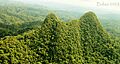
The reserve includes both mountains and flat tropical rainforest areas. It is full of different kinds of wildlife and plants. More than 2,000 people live here. The Río Plátano Biosphere Reserve is also part of a larger natural pathway called the Mesoamerican Biological Corridor. This corridor stretches all the way from Mexico down through Central America.
Even though the reserve is very large, we don't know much about all the different living things inside it. There are still problems like illegal hunting, cutting down trees, and clearing land for cattle. Recent trips down the Río Plátano have shown cattle grazing in protected areas. People have also seen commercial fishing and hunting camps along the river. Trees are being cut down near the village of Las Marias.
Contents
History of the Río Plátano Reserve
In 1960, this land was first set aside as the "Ciudad Blanca Archaeological Reserve." It was named after a rumored ancient city called la Ciudad Blanca. Later, in 1980, the reserve was renamed the "Río Plátano Biosphere Reserve." It was then added to the World Heritage list in 1982.
A plan to manage and develop the reserve was created in 1980. It was put into action in 1987 by the Department of Natural Renewable Resources. In 1997, an extra 3,250 square kilometers (1,255 square miles) were added as a buffer zone. This zone helps protect the main part of the reserve.
Ancient Sites and Hidden Cities
The reserve has more than 200 ancient sites. One important spot is where Christopher Columbus first landed on the mainland of America. There are also old settlements with stone buildings, roads, and rock carvings.
Sadly, many of these sites are not well protected. Some have been looted, and others are at risk because more tourists are visiting. Even though these ancient sites were a big reason for creating the reserve, today the main focus is on protecting the forests.
Local stories say that the legendary city of La Ciudad Blanca (The White City) is hidden in this area. Many people have claimed to find it, but no one has shown real proof. Most experts don't believe it ever truly existed.
People Living in the Reserve
The Río Plátano Reserve is home to over 2,000 native people. More people from other areas are also moving in. There are four main cultural groups living here: the Miskito, Pech, Garifunas, and the ladino.
The smaller groups, like the Pech, Garifunas, and Miskito, mostly live in the northern part of the reserve, near the river. These groups have rights to the land and often use it for farming. The Pech people's small-scale farming methods are usually sustainable.
The largest group, the ladino people, have mostly moved into the reserve from the south. There are often disagreements over land rights between these different groups. People who are not native to the area are sometimes moving onto and threatening the land of the native people. This can force them to leave their traditional homes.
Protecting the Reserve
In 1996, the reserve was put on the World Heritage in Danger list. This happened because of too much logging and farming expansion. A new plan to manage the reserve was started in 2000. It divided the reserve into different zones: buffer zones, cultural zones, and core zones.
By 2006, the threats, especially in the core zones, had gone down. This showed that conservation efforts were working. So, in 2007, the reserve was removed from the "in danger" list. However, checks in 2010 and 2011 showed that these improvements didn't last. UNESCO visited the Río Plátano in 2011 and found illegal activities in the core zone. Because of this, in 2011, UNESCO put the reserve back on the List of World Heritage in Danger.
The Department of Protected Areas & Wildlife in Honduras protects the area. It also gets money from groups like the World Wildlife Fund. Many government and non-government groups are working to protect this region. The main goal is to stop trees from being cut down and to prevent too much development.
The conservation plan tries to help local people live in a way that protects the environment. This includes using sustainable farming methods. Native populations are very important for the success of this plan. This is true both inside and outside the reserve. Giving people official land titles helped start the conservation plan. However, the plans need to be updated as the region changes.
More research is needed to understand the full value of the reserve and the dangers it faces. Currently, there are no park guards or official groups actively patrolling the reserve.
Climate and Weather
The reserve gets a lot of rain, between 2,850 and 4,000 millimeters (112 to 157 inches) each year. Local people have noticed that the dry seasons are getting longer over time. The climate is very important for keeping the wet forests healthy. It is also vital for the farming that the native people rely on.
The reserve also experiences about four strong tropical storms every ten years. These storms affect the entire reserve through its many waterways. Farming and development plans depend on the river's natural banks to drain water from low areas. For example, Hurricane Mitch in 1998 stopped the building of a power plant called Patuca II.
Geography of the Reserve
The land stretches from the La Mosquitia coast, through lagoons, and along the Río Plátano up into the mountains. The buffer area also includes the Paulaya and Sico valleys. It will eventually reach the Patuca River. Most of the reserve is mountainous. It includes Pico Dama, a huge granite rock, and Punta Piedra, which is the highest peak at 1,326 meters (4,350 feet).
The reserve includes almost the entire area that drains into the Río Plátano. It also has many other smaller waterways. Much of the region is covered with mountains. The rivers flow through both the lower and mountainous areas. The river forms many loops, called oxbows, as it crosses the long, flat lowlands. These lowlands separate the hills from the lagoons. The river has also created oxbow lakes, marshes, and natural banks.
The way the land is shaped makes farming and conservation difficult. The low-lying areas are covered with water during the winter. The rivers and their smaller streams are home to many different plants. The coastal area to the north is better known, but the rest of the region needs more exploration.
Amazing Plants and Animals


The Río Plátano Reserve has one of the largest untouched tropical rainforests in Honduras. It is also one of the few left in Central America. This forest is home to many species that are in danger of disappearing. While we are learning more about the plants and animals here, current plans still ask for more research. This is especially true for areas near rivers.
Flora: The Plants of Río Plátano

The main plant environments include mangrove forests, freshwater swamps, marshes, grassy prairies, pine savannas, and river forests. There are many different kinds of plants, possibly over 2,000 species. However, not much has been written about them because many are new or undiscovered.

Along the coast, there are two major mangrove areas: the Brus Lagoon and the Iban Lagoon. The Brus area is 120 square kilometers (46 square miles) and has salty water. The Ibans area is 63 square kilometers (24 square miles) and has fresh water. Mangroves are very important and delicate, making them a valuable part of the reserve.

Further inland, the land turns into prairies and savannas with pine and palm trees. This depends on how much water is available. Along the rivers, the plants form thick, wet forests. These areas are also not well studied.

Fauna: The Animals of Río Plátano
The animals recorded in the region include 39 types of mammals, 377 types of birds, and 126 types of reptiles and amphibians. The area is especially rich in birds. Some examples are the king vulture, harpy eagle, great curassow, crested guan, scarlet macaw, green macaw, and military macaw.


Common mammals found here include white-headed capuchin monkeys, mantled howler monkeys, spider monkeys, brown-throated sloths, pacas, kinkajous, coatis, Central American otters, pumas, collared peccarys, white-lipped peccarys, and red brocket deer.
Because the reserve is so large and its forests are mostly untouched, it is home to many rare or endangered mammals. These include Baird's tapir, giant anteaters, jaguars, ocelots, margays, and Caribbean West Indian manatees. The first jaguar ever filmed in Honduras was seen in this reserve in 2007.
There is not much education about the environment in Honduras. This makes it hard to protect these endangered species. Widespread poverty and a lack of good research also make protection more difficult. While conservation programs are meeting their goals, it's hard to know if they are directly protecting these species. However, protecting the rainforests and other environments that these animals depend on is a very important indirect benefit.
Tourism in the Reserve
The large number of wild animals along the La Mosquitia coast makes it a popular place for ecotourists. Ecotourism means traveling to natural areas in a way that helps protect them. Private groups are starting ecotourism businesses here. However, the government does not have a full plan to manage or benefit from these tourists.
Ecotourism can help local people who are struggling with poverty. It can also make more people aware of the reserve's natural value. The money earned can help fund projects for the reserve. Currently, there are guided rafting trips that last 10 to 12 days down the entire Río Plátano.
While well-managed tourism could help the reserve, the current unregulated tourism has caused problems. It has led to too much traffic and damaged ancient sites. The tourism industry affects the entire reserve, but the unprotected ancient sites are especially hurt. Without better facilities, it is hard to have a successful and sustainable ecotourism industry. This is especially true in a reserve that already has many conservation challenges.
Challenges for Conservation
Even though there has been progress in protecting the reserve since 2006, it still faces some big threats. Cutting down trees and new development continue to be problems. The situation is made worse by more people moving into the area. These people often come from poorer parts of Honduras or are refugees from Nicaragua.
Illegal Logging
The government tries to control the logging industry in Honduras. They do this through the Honduran Cooperation for Forestry Development. Even with these groups watching, mahogany trees are still being cut down and removed illegally from inside the reserve. The Honduran government has not made laws strong enough to stop deforestation. The entire reserve could quickly disappear if illegal logging continues.
Local people admit that a lot of mahogany is leaving the reserve. However, many poorer people see the high price of mahogany as a reason to cut down valuable forests. These forests provide important benefits to the water and soil. It is still mostly unknown who is behind much of the illegal logging in the reserve.
New Development and Farming
New buildings and farms inside and around the reserve create problems for conservation plans. The building of the Patuca II hydroelectric power plant on the Patuca River shows these challenges. A power plant does more than just affect the river where it is built. It also needs roads and other structures that disturb the environment around it. Much of the reserve does not have developed roads or power. A hydroelectric plant would require development throughout the reserve.
Farming throughout the reserve is a more direct threat. As the number of people in the reserve grows, so do their farming activities. Much of the wetland area is not good for farming. It needs banks and ongoing development to be productive. People claiming land without legal ownership has led to conflicts, sometimes violent, between different cultural groups over farming areas.
Poorer farmers sometimes use destructive methods, like slash-and-burn. This is especially harmful to the savanna and prairie lands. The current management plan aims to teach farmers about these destructive practices, but they still continue. Future plans hope to encourage sustainable farming methods among more traditional farmers.
Refugees and Population Growth
Poverty in Honduras and nearby Nicaragua, along with more hurricanes, have caused many people to seek refuge in the reserve. This makes conservation efforts even more complex. These refugees often enter from the south of the reserve. Sometimes, this creates more conflict with the native populations. While traditional farming can be somewhat damaging, the stress from larger populations is much more harmful to the reserve.
Currently, the Honduran Corporation for Forestry Development, with help from the Honduran Public Safety Force, patrols the reserve. They hope to reduce the number of people who enter illegally. But despite their efforts, refugees continue to come in. The reserve considered a plan to move refugees outside the reserve. This would create a larger buffer zone and reduce stress inside the reserve. However, this plan faced political opposition.
Images for kids
-
Cerro Chachahuate
See also
 In Spanish: Reserva de la biosfera de Río Plátano para niños
