Rangiaowhia facts for kids
Quick facts for kids
Rangiaowhia
|
|
|---|---|
|
former Village
|
|
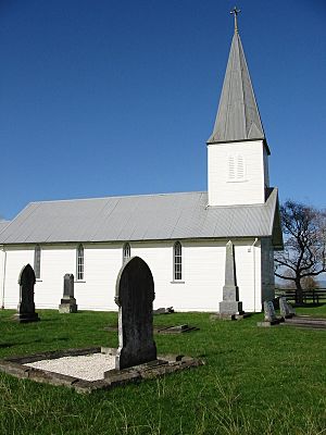
St Paul's Church (Anglican) at Rangiaowhia
|
|
| Country | New Zealand |
| Region | Waikato region |
| District | Waipa District |
| Elevation | 60 m (200 ft) |
| Population
(2013 census)
|
|
| • Territorial | 102 |
| • Estimate
(1852)
|
700 |
| Time zone | UTC+12 (NZST) |
| • Summer (DST) | UTC+13 (NZDT) |
| Rangiaowhia | |
|---|---|
| Designated | 23 June 1983 |
| Reference no. | 27 |
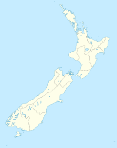
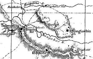
Rangiaowhia was a busy village in the Waikato region of New Zealand. It was located on a ridge between two streams, about 4 kilometers east of Te Awamutu. For over 20 years, starting in 1841, Rangiaowhia was home to a very successful Māori mission station. A mission station was a place where missionaries lived and taught about Christianity, often also helping with farming and education.
This station served the Ngati Hinetu and Ngati Apakura Māori groups. Today, only a church from those early days remains. It is the second oldest building still standing in the Waikato region.
Contents
A Thriving Village
In the 1850s, Rangiaowhia was a very important and productive place. In 1851, people described it as having about 1,000 acres of land being farmed. Many Māori people worked hard in farming and other industries. It was thought that Rangiaowhia would soon become a major food supplier for Auckland.
The village looked a lot like English farms, with yellow cornfields and orchards around the houses. Mills, tools for threshing grain, and ploughs were always busy. A bell called people to church or school. The village was a great example of how the Māori people were making their land fruitful. They were also helping to keep peace in the area.
By 1852, the village was described as being two miles long. It had a population of about 700 people. A letter from 1857 suggests that 14 different hapū (Māori family groups or clans) lived there. They had turned unused land into busy farms.
Before the Waikato War began in 1864, a magistrate named John Eldon Gorst wrote about the area. He said the land around Rangiaowhia and Te Awamutu belonged to the great Waikato tribe. Besides the main villages, many small hamlets were scattered around. These had a few Māori houses surrounded by their own cultivated land. Even areas that looked like empty fern land were once farmed. They were then used for grazing horses, cattle, or pigs.
Gorst noted that Rangiaowhia was surrounded by a fence many miles long. Roads were built in different directions, and bridges crossed swamps. Many mill-dams had also been built. A generation earlier, much of the land was covered in old forests. The hard work of the Waikato people had cleared these forests.
Churches in Rangiaowhia
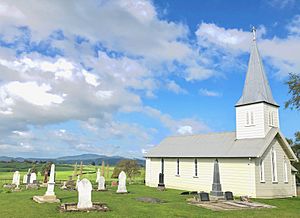
St Paul's Church was built between 1852 and 1856. It was part of the Church Missionary Society station. It replaced an earlier chapel made of raupo (a type of reed). St Paul's and St John's in Te Awamutu are the oldest surviving buildings in the Waikato.
The church was built in the Gothic Revival style. It first had a bell tower, a main hall (nave), and a chancel (the area around the altar). The chancel has two stained glass windows. They show St Paul meeting a magician. Bishop Selwyn brought them from Britain in 1855. They are thought to have been given by Lady Burdett Coutts. A missionary teacher, Taati Te Waru, added a steeple around 1857.
During the attack by Imperial forces, the church gave shelter to Māori people. After the attack, it was empty until it was repaired in the 1870s. It then became a parish church and a school. Today, it is still used for church services.
The Catholic Holy Angels mission station was about 400 meters north of St Paul's. Father Jean Pezant moved it there from Matamata in 1844. In 1850, Father Joseph Garavel took over. Part of the mission station burned down by accident in 1865. The church was taken down in 1931. However, the cemetery is still there. A memorial pou (a carved wooden pole) was put up in 2015. The bishop's house was across the valley, to the east.
Schools in Rangiaowhia
Both the Anglican and Catholic missions had schools. Reverend John Morgan ran an Anglican school with over 40 students. It cost £5 a year for living and learning. Students were taught English, singing, practical skills, and religion. In May 1860, Father Garaval had 24 boys in his school. He left because of the war. By 1876, only one girl was attending the school.
Crops and Farming
Soon after Reverend Morgan took over the Otawhao (Te Awamutu) mission station in 1841, wheat was grown there. The next year, it was also grown at Rangiaowhia. Soon, Rangiaowhia's wheat fields covered about 450 acres. Other crops included barley, oats, potatoes, peaches, apples, pears, plums, quinces, gooseberries, and almonds. Cows were milked, and pigs were sold in Auckland. A blacksmith kept the ploughs and other tools in good repair.
Mills for Flour
In March 1846, work began on building a mill. It cost £200, not including moving the timber or building the dam and water channel. The mill started grinding flour in 1847. Its millstone, which was 2 feet 10 inches wide, came from Mt Eden. By 1848, flour from Rangiaowhia was sold in Auckland for about £70. In later years, this amount reached about £330.
The 1846 mill was at Pekapekarau, in the valley to the west. A new mill was built between 1851 and 1855 for £400. It was located on the Te Rua-o-Tawhiwhi stream, east of Rangiaowhia. Both of these streams flow into the Mangapiko Stream, which is a branch of the Waipa River. There were also mills in most of the nearby settlements.
Governor Grey visited the mill in 1849. He was given two bags of flour as a gift for Queen Victoria. He also spent half a day at Rangiaowhia in 1857. During the gold rushes from 1849 to 1852, flour from Rangiaowhia was often sent by ship to San Francisco and Melbourne.
The Invasion of Rangiaowhia
In 1858, Pōtatau was made the first Māori King at Rangiaowhia. After this, the New Zealand government saw Rangiaowhia as a target to control. To protect against this, new defensive forts called pā were built. These were at Paterangi and Rangiatea, which guarded the roads to Rangiaowhia.
However, General Cameron, leading the Invasion of the Waikato, avoided these forts. He took 1,230 troops overnight from Te Rore. They arrived in Te Awamutu at dawn, leaving a large force to distract the Paterangi pā.
Nine days before the attack, Bishop George Selwyn, who was a chaplain for the army, was told that women, children, and elderly people would be taking shelter at Rangiaowhia. This village was not fortified or defended. Bishop Selwyn was asked to tell General Cameron this. The Kingitanga leaders understood that these people would be safe. About 200 Ngati-Apakura and Ngati-Hinetu people were at Rangiaowhia. They were supplying food to the forts.
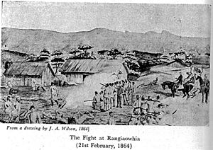
At dawn on February 21, 1864, armed cavalry (soldiers on horseback) attacked Rangiaowhia. Foot soldiers followed them. Most of the terrified villagers ran away. A few shot at the troops, and some hid in the churches. About a dozen houses were burned down. Official British records say 12 Māori were killed, including two chiefs. Over 30 were taken prisoner. The British lost five soldiers, including some officers. However, some unofficial guesses suggest that more than 100 Māori people died. Since the village was mostly occupied by women, children, and older men, these deaths have been seen as murder, not just an act of war.
Later that day, the men from Rangiaowhia left the Paterangi, Pikopiko, and Rangiatea pā. They went to defend their families. They dug a rifle-trench with a narrow opening to block the road from Te Awamutu at Hairini. The next morning, February 22, the cavalry moved towards Hairini. They were supported by artillery (big guns) and foot soldiers. Three British soldiers and about 20 Māori died, though these numbers are also debated. The troops then looted the village. Some people think the Hairini defense was a trick to allow more time to move goods and animals south to safety. However, enough was left for looting to continue for at least a month after the invasion.
Bishop Selwyn's role in the Rangiaowhia attack is not fully clear. He came with the attacking forces, but he also helped with Māori burials. The wife and two daughters of Kereopa Te Rau were killed in the attack. His sister was killed defending the Hairini line a few days later. Colonel Marmaduke Nixon, who led the cavalry charge at Rangiaowhia, was badly wounded and later died. He is buried at the Nixon memorial in Ōtāhuhu, Auckland. There were no memorials to the victims of Rangiaowhia until the 150th anniversary in 2014. A plaque was unveiled then.
In 2021, a documentary about the Rangiaowhia attack was released. It is called NZ Wars: Stories of Tainui. It was made by Great Southern Television and Aotearoa Media Collective for RNZ. The documentary is presented by Mihingarangi Forbes. It includes interviews with historian Vincent O’Malley and iwi (tribal) historians Rahui Papa, Brad Totorewa, Tom Roa, Mamae Takerei, and Kawhia Muraahi.
Redoubt Built
A fort called a redoubt was built in February 1864. It was designed for 200 men. This redoubt is now in the Hall domain, which was once a school. In the 1870s, a blockhouse (a strong, small fort) was added. It was staffed by the Armed Constabulary, a police force.
Rangiaowhia After 1864
Within a month of the invasion, the government led by William Fox made an announcement. It said that rebels who gave up would get some of their land back. But those who did not surrender would have their land taken away. By 1868, there was worry about the anger caused by military settlers taking over the land.
The church was repaired in 1875. Rangiaowhia riding (a local government area) was created in 1876. It was one of five ridings in Waipa county. Its southern border was the Puniu River. A state school near the hall operated from 1874 to 1939. Then, several schools joined together to form a larger Te Awamutu school. The school house from about 1900 is still there, as is the hall, built in 1907.
Population Today
Rangiaowhia is in an area called Meshblock 0987100. In the 2013 census, 102 people lived there. In 2006, there were 90 people, and in 2001, there were 93.
Famous People from Rangiaowhia
- Lloyd Mandeno (1888–1973), an engineer and inventor.
|
 | May Edward Chinn |
 | Rebecca Cole |
 | Alexa Canady |
 | Dorothy Lavinia Brown |


