Read's Island facts for kids
| Administration | |
|---|---|
|
England
|
|
| County | |
| Civil Parish | Winteringham |
| Demographics | |
| Population | 0 (2011) |
| Read's Island | |
|---|---|
| OS grid reference | SE931221 |
| District | |
| Shire county | |
| Region | |
| Country | England |
| Sovereign state | United Kingdom |
| Postcode district | DN15 |
| Police | Humberside |
| Fire | Humberside |
| Ambulance | East Midlands |
| EU Parliament | Yorkshire and the Humber |
| UK Parliament |
|
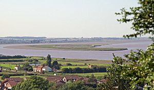
Read's Island is an island located in the Humber Estuary in England. It sits near the Ancholme sluice. Some people think it's an artificial island, meaning it was made by humans. A report from 1979 even said it was "reclaimed" land.
However, this area was once a large sandbank called "Old Warp." Maps from 1734 show this sandbank exactly where Read's Island is now. A local history website suggests that both ideas are true. It says that two shipwrecks, including one sunk on purpose, helped the island form. This was done to protect the southern riverbanks near South Ferriby.
The size of Read's Island has changed a lot over time. In 1872, it was about 300 acres. By 1886, it grew to 491 acres. But in 2008, it had shrunk to 200 acres. After big floods in 2007, parts of the island needed to be rebuilt. This was important for birds like avocets, who use the island to breed.
Contents
How Read's Island Was Formed
The Imperial Gazetteer of England and Wales, an old reference book, says that Read's Island was made of "Pudding-Pie sand." It also suggests the island got its name from a Mr. Read of Burton Stather.
By the late 1700s, grass started growing on the "Old Warp" sandbank. Farmers then brought cattle to graze there. The Humber Estuary is a very important waterway. It collects water from a large part of the Midlands, including the River Trent, and from Yorkshire via the River Ouse. The river also has strong tides.
Over time, people helped the island grow. They placed piles of bricks and concrete in strategic spots. This process is called "warping." It allowed rich silt from the river to build up, creating more land. The island was protected, and more land was reclaimed from the Humber. By 1861, there was even a wooden cottage and a fresh water well on the island.
A Look Back: Island History
Read's Island has a fascinating past, including its role during wars and its use for farming.
Military Events on the Island
During World War I (1914–1918), German prisoners of war helped rebuild the brick flood walls on the island. Later, during World War II, the island saw some military action.
- On May 21, 1942, an Airspeed Oxford plane crashed into the east side of the island. It belonged to No 15 PAFU from RAF Kirmington.
- On December 24, 1944, a V-1 flying bomb (a type of rocket) crashed into the mud near Read's Island. This was part of a coordinated attack on Manchester by German Heinkel 111 aircraft. These rockets were launched from planes to increase their range.
Farming and People on the Island
In 1871, the Humber Conservancy bought the island from the Crown Estate for about £1,434. This amount would be worth around £935,000 today. The land was then rented out to farmers.
Most of Read's Island is part of the Winteringham parish, even though South Ferriby is the closest village. People have lived on the island at different times. It was once a farm where cattle roamed freely. During very low spring tides, cattle could even walk across the mud to reach the mainland. However, in the 1930s, cattle had to be moved by barge. At that time, the island was about 600 acres and used for summer grazing. It was also well-known for its wildlife, especially hares.
Wildlife and Nature on the Island
Read's Island is a special place for birds and other animals. It is a RSPB reserve. This means it's protected because of its importance for birdlife.
Many different species either migrate to the island or live there all year round. These include:
- Ground-nesting avocets: About 10% of all avocets in the UK breed here.
- Greylag goose
- Pink-footed goose
- Marsh harrier
- Lapwing
- Wigeon
- Curlew
- Golden plover
- Fallow deer
The Humber River's main shipping channel sometimes shifts. This can affect the island's shape and size. The flow of freshwater from the estuary also plays a role in how the island changes over time.
Island Name: A Little Confusion
You might see Read's Island spelled in different ways. The Ordnance Survey and most maps use "Read's Island." However, some people spell it "Reads Island," "Reed's Island," or even "Reeds Island." One document even used both "Reed's" and "Read's" in the same paragraph!
It is believed that the Read brothers from Burton upon Stather were the first to graze cattle on the island. This is likely how the island got its name.
 | Aurelia Browder |
 | Nannie Helen Burroughs |
 | Michelle Alexander |


