
Riverside Country Park facts for kids
Quick facts for kids Riverside Country Park |
|
|---|---|

Footpath Junction in Riverside Country Park
|
|
| Lua error in Module:Location_map at line 420: attempt to index field 'wikibase' (a nil value). | |
| OS grid | TQ808683 |
| Area | 247 acres (1.00 km2) |
| Created | 1970s |
| Operated by | Medway Council |
| Status | Open 7 days a week, dawn until dusk |
| Website | Riverside Country Park |
Riverside Country Park is a huge park right by the River Medway in Kent, England. It's located between the towns of Gillingham and Rainham. This amazing park covers about 100 hectares, which is roughly the size of 247 football fields!
The park is a special place for nature. It has many different natural areas like muddy riverbanks, salty marshes, calm ponds, and grassy fields. These different habitats make it a perfect home for lots of different animals and plants. It's a real wildlife haven!
Contents
Discovering Riverside Country Park's Past
The coastline around Gillingham has a very long and interesting history. Riverside Country Park was created in the 1970s by Medway Council. It includes several cool areas like Motney Hill, Rainham Dock, Bloors Wharf, Horrid Hill, Sharp's Green Bay, and Eastcourt Meadows.
Ancient Times at Rainham Docks and Motney Hill
People have lived in this area for a very long time. Scientists have found clues that show people were here during the Neolithic period (the New Stone Age). Later, the Romans used this area as a burial ground.
Like much of the Medway area, this land was once very fertile. Farmers grew lots of hops, cherries, plums, apples, and wheat here.
In 1819, Motney Hill appeared on maps as an island. It was also called 'Gritty Island' because it had so much sand. In 1901, a company called British Standard Cement Company started taking chalk from a big pit nearby. This chalk was sent to London. That chalk pit is now known as Berengrave Local Nature Reserve.
A cement works (a factory that makes cement) was built on Motney Hill island in 1912. When the tide was high, special boats called barges would sail into the river. Workers, nicknamed 'Muddies', would collect mud from the riverbed and load it onto the barges. As the tide came back in, the barges would float again and sail to Rainham Dock. There, the mud was mixed with chalk and heated at very high temperatures to make cement.
Barges then left Rainham Dock carrying cement and flints. These materials were used to build roads and buildings. The barges would return with coal (to heat the cement factory's kilns) and timber. The timber was used by local businesses to make staves, which are wooden slats for making barrels. These barrels were then used to transport the cement.
The cement factory closed in the 1930s, and its buildings were taken down. However, the old dockside still remains today. The chalk pit also closed in 1931 after the factory shut down.
Motney Hill has also been called Motley Hill on some older maps.
In 1923, a pumping station and sewerage system were built on Motney Hill. It started cleaning waste water from Rochester and Chatham, and later from Gillingham. Over the years, the system has been updated. Today, it handles over 10 million gallons of waste water every day!
Bloors Wharf: From Fishing to Scrap

Maps from 1869 started showing a small quay (a landing place for boats) here. Bloors Wharf began as a place for fishermen. Later, it had warehouses and eventually became a scrap yard where old ships were taken apart.
Now, all the old buildings at the wharf have been removed. It's an empty space with a concrete sea wall and a steel fence.
Horrid Hill: A Tough Place to Work


In the 1860s, a man named Alfred Castle used to dock his boats in Sharp's Green Bay. He collected chalk from a nearby quarry in Twydall. Then, he would sail across the water to his two cement factories on Queenborough on the Isle of Sheppey.
The chalk was brought from the quarry to the barges by carts. The barges were loaded by hand when the tide was low. This was because the boats needed enough water under their keel (the bottom part) to float off the mud when the tide came in.
Later, Alfred built a wooden jetty (a pier) further down the river. This allowed barges to load chalk at both high and low tides. To make loading even faster, he built a narrow gauge horse-drawn railway from the quarry to the new wooden jetty. The railway trucks had sides that could tip, so they could easily dump their loads into the barges. Alfred and his brother James owned seven barges. Their factories produced 400 tons of cement each week!
In 1890, Joseph Wilders and Franic Joseph Carey were looking for a place to build their own cement factory by the coast. They made a deal with Alfred Castle to use the eastern side of the peninsula. The new factory needed some land to be built up. They did this by making the existing causeway (a raised road over water) longer and extending the railway to the factory on the island. It was one of the smallest cement factories ever built. A wharf made of timber and concrete was also built. This allowed barges to unload coke (a type of fuel) and clay.
When the factory was fully working, Carey and Wilders hired a small team of men who worked in shifts. It was a very tough place to work, especially in winter. This is how it got its nickname, Horrid Hill.
The cement factory closed in 1910. However, chalk was still taken from the quarry and sent to the Queenborough cement works for many years. The last boat to dock there was a barge called the "Dick Turpin." It ran aground in the river near Horrid Hill in 1913. You can still find some of its cargo of Dundee marmalade jars in the River Medway!
Sharp's Green Bay: A Home for Wildlife

Close to the park's visitor centre is Sharp's Green Pond. This is a small pond with fresh water, protected by a clay sea wall. It helps to encourage many different types of wildlife to live in the park. Sharp's Green Bay (which is to the left of the Horrid Hill causeway) is a small tidal marsh bay. A few houseboats are moored here. There's a small car park at the bay, reached by a narrow road from Lower Rainham Road.
Copperhouse Marshes are salt marshes. They get their name from the copperas works that used to be in nearby Gillingham. Copperas (also known as Iron(II) sulfate) was a dye used for woollen cloth and for tanning leather. It was made by soaking iron pyrites in wooden vats for about six years. Then, the liquid was boiled until the water evaporated, leaving behind crystals of the dye. There were Copperas factories in Queenborough in the 1500s and also at Whitstable.
Eastcourt Meadows and the Park's Beginning
In 1928, Rainham became part of Gillingham Borough. This land, which used to be farmland, was then used by the council to dump rubbish. This stopped in the 1950s, and now it's a wild meadow. In 1987, the expanded Riverside Country Park officially opened. It had first opened in the 1970s. Later, the land north of the B2004 road was officially made a country park under the Countryside Act 1968.
In 1997, Medway Council started buying more land to add to Riverside Country Park. This included Eastcourt Wood, Marsh Field, Mariner’s Field, Bloors Wharf, Bloors Field, and Motney Field. Work then began to remove old buildings, scrap metal, and pollution from Bloors Wharf to make it part of the new park.
Fun Things to Do and See at the Park

Medway Council takes care of this park. It has a visitor centre with a cafe, toilets, and an information point. You can find it in the main car park on Lower Rainham Road.
The Saxon Shore Way, a long-distance walking path, goes right through the park along the coast. It connects Upchurch and Gillingham. The National Cycle Route 1 also follows the Saxon Shore Way through the park, so you can cycle here too!
The park offers great places to see the North Kent Marshes and the River Medway.
Riverside Country Park has also won a Green Flag Award from Natural England. This award means it's a well-managed and high-quality green space.
Motney Hill is now a special reserve managed by the RSPB. It's a headland that sticks out into the River Medway.
Berengrave Local Nature Reserve covers about 15 hectares (37 acres). Most of it is the former site of the Cement Works of Rainham Docks. The river estuary (where the river meets the sea) is very important. It's protected as part of the Medway Marshes Site of Special Scientific Interest (SSSI). This area is super important for birds that spend the winter here. They love the muddy riverbanks, which are full of tiny creatures. Many types of wading birds, ducks, and geese come here. The salt marshes also have special plants and animals, and they are safe places for birds to rest when the tide is high.
How to Get to Riverside Country Park
If you're coming from the A2 London Road in Rainham, follow the B2004 Lower Rainham Road towards Gillingham.
The country park has two car parks. One is where the visitor centre is, near Sharp's Green Bay and Horrid Hill. The other car park is closer to Motney Hill and Bloors Wharf.
Images for kids
-
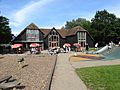
Riverside Country Park visitor centre and playground

