Roberts County, Texas facts for kids
Quick facts for kids
Roberts County
|
|
|---|---|

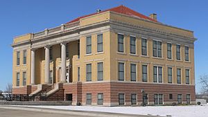
Roberts County courthouse in Miami
|
|

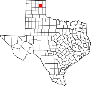
Location within the U.S. state of Texas
|
|
 Texas's location within the U.S. |
|
| Country | |
| State | |
| Founded | 1889 |
| Named for | John S. Roberts and Oran Milo Roberts |
| Seat | Miami |
| Largest city | Miami |
| Area | |
| • Total | 924 sq mi (2,390 km2) |
| • Land | 924 sq mi (2,390 km2) |
| • Water | 0.1 sq mi (0.3 km2) 0.01% |
| Population
(2020)
|
|
| • Total | 827 |
| • Density | 1/sq mi (0.4/km2) |
| Time zone | UTC−6 (Central) |
| • Summer (DST) | UTC−5 (CDT) |
| Congressional district | 13th |
Roberts County is a county in the state of Texas. In 2020, about 827 people lived there. This makes it one of the least populated counties in Texas. The main town and county seat is Miami. Miami is also the only town in the county.
Roberts County was created in 1876 and officially started in 1889. It is named after Oran Milo Roberts, who was a governor of Texas.
Contents
History of Roberts County
The Plains Apache people once lived in the Texas Panhandle area. Later, the Comanche tribe took over the land. They were the main group in the area until the 1870s. The Comanche hunted large herds of buffalo that lived on the open plains.
In 1874–75, the United States Army fought the Red River War. Soldiers led by Ranald S. Mackenzie made the Comanches leave the area. At the same time, buffalo hunters killed many of the large buffalo herds. This took away the food and way of life for the Plains tribes. This made it possible for new settlers, called Anglo-Americans, to move in.
In 1876, Roberts County was formed from parts of the Bexar Territory. In 1887, the Southern Kansas Railway built train tracks through the county. More settlers then came to live there.
Roberts County has recently been involved in a fight over water rights. The City of Amarillo, Texas, the Canadian River Municipal Water Authority, and T. Boone Pickens wanted to buy water rights in the county. Together, they own most of the water rights there.
Geography of Roberts County
Roberts County covers about 924 square miles. Only a very small part of this area is covered by water.
The county is mostly flat land. The Canadian River valley is the main exception. Most of the land in Roberts County is used for raising cattle. The county also has the Mesa Vista Ranch, which is very large. This ranch works to protect birds like quail, dove, and pheasant. These birds live along the creek beds south of the Canadian River.
Main Roads
Neighboring Counties
- Ochiltree County (north)
- Lipscomb County (northeast)
- Hemphill County (east)
- Gray County (south)
- Carson County (southwest)
- Hutchinson County (west)
- Hansford County (northwest)
- Wheeler County (southeast)
Population Information
| Historical population | |||
|---|---|---|---|
| Census | Pop. | %± | |
| 1880 | 32 | — | |
| 1890 | 326 | 918.8% | |
| 1900 | 620 | 90.2% | |
| 1910 | 950 | 53.2% | |
| 1920 | 1,469 | 54.6% | |
| 1930 | 1,457 | −0.8% | |
| 1940 | 1,289 | −11.5% | |
| 1950 | 1,031 | −20.0% | |
| 1960 | 1,075 | 4.3% | |
| 1970 | 967 | −10.0% | |
| 1980 | 1,187 | 22.8% | |
| 1990 | 1,025 | −13.6% | |
| 2000 | 887 | −13.5% | |
| 2010 | 929 | 4.7% | |
| 2020 | 827 | −11.0% | |
| U.S. Decennial Census 1850–2010 2010 2020 |
|||
In 2000, there were 887 people living in Roberts County. There were 362 households and 275 families. The county had less than one person per square mile.
About 31.8% of households had children under 18. Most households (70.7%) were married couples. About 23.8% of all households were single people. About 10.8% of households had someone 65 or older living alone.
The average age in the county was 42 years old. About 25% of the people were under 18. About 14.4% were 65 or older.
The average income for a household was $44,792. For a family, it was $50,400. About 7.2% of the population lived below the poverty line. This included 7.5% of those under 18.
The largest groups of people by their family background in Roberts County are:
- English (23.7%)
- German (18.4%)
- Irish (15.2%)
- American (8.8%)
Towns and Communities
See also
 In Spanish: Condado de Roberts (Texas) para niños
 | Dorothy Vaughan |
 | Charles Henry Turner |
 | Hildrus Poindexter |
 | Henry Cecil McBay |

