
Rock Island, Washington facts for kids
Quick facts for kids
Rock Island
|
|
|---|---|
| Rock Island, Washington | |

View of Rock Island, looking east up the Columbia River towards the Great Northern Railway bridge
|
|

Location of Rock Island, Washington
|
|
| Country | United States |
| State | Washington |
| County | Douglas |
| Area | |
| • Total | 1.40 sq mi (3.62 km2) |
| • Land | 1.13 sq mi (2.92 km2) |
| • Water | 0.27 sq mi (0.70 km2) |
| Elevation | 643 ft (196 m) |
| Population
(2020)
|
|
| • Total | 1,279 |
| • Density | 914/sq mi (353.3/km2) |
| Time zone | UTC-8 (Pacific (PST)) |
| • Summer (DST) | UTC-7 (PDT) |
| ZIP code |
98850
|
| Area code | 509 |
| FIPS code | 53-59180 |
| GNIS feature ID | 1525135 |
| Website | http://rockislandwa.org/ |
Rock Island is a city located in Douglas County, Washington, in the United States. It's part of the larger Wenatchee and East Wenatchee area. In 2020, about 1,279 people lived there.
Contents
History of Rock Island
Rock Island officially became a city on November 3, 1930. Long before settlers arrived, Native American tribes used this area. They fished and crossed the Columbia River here. This was because of the nearby Rock Island Rapids, which made crossing easier.
Early Settlements and Names
In the late 1800s, the area was first settled. It was known as Hammond back then. Some old maps might even show it as Hammond P.O. (Post Office) or Power City. In the early 1860s, two men named Ingraham and McBride opened a trading post. They traded with local Native Americans who often fished in the Columbia River. Later, these men moved their post, leaving little behind.
James E. Keane and the Railroad
The most important person in Rock Island's early history was James E. Keane. He was the first permanent settler in the area. Keane arrived in 1887 with a group of workers. He planned to build a home and improve the land he had claimed. Four years later, the Great Northern Railroad started surveying the area. They began building tracks towards the valley from the east.
Keane created a townsite about half a mile from the Rock Island Rapids. He named this first townsite Hammond. However, the Great Northern Railway changed its plans. Hammond was then moved about 2.5 miles south to a new spot. Keane renamed this new location Rock Island. The name came from the rocky islands found in the Columbia River nearby.
Between 1891 and 1893, Rock Island became very important for the railroad. A huge steel bridge was built across the Columbia River. Many workers came to the area for this project. The small town grew quickly. Several stores opened to serve the workers. A local newspaper, the Rock Island Sun, also started publishing.
Boom and Bust Cycles
People thought Rock Island would become the biggest city in the area. It was near the Rock Island Rapids and had the important railroad bridge. But despite these advantages, the larger city ended up being Wenatchee. Wenatchee is just seven miles upriver from Rock Island. In 1893, the first bridge across the Columbia was finished. This marked a downturn for Rock Island. With fewer jobs, the railroad workers moved away.
Rock Island boomed again in 1930. The Puget Sound Power and Light Company began building a dam. This dam was just below the Rock Island Rapids. The project cost about 10 million dollars. The Rock Island Dam was the first dam on the Columbia River. On November 3, 1930, Rock Island officially became a town. It had 421 residents. The town grew a second time as dam workers created temporary villages. But this growth didn't last. By 1931, two of the dam's generators were making power. The final spillway closed in 1932. Rock Island again saw its population drop.
Many Native American pictographs (rock paintings) were lost when the Rock Island Dam was built. A few pictographs were saved before construction. You can see them at the Wenatchee Valley Museum & Cultural Center in nearby Wenatchee. During World War II, a silicon smelter was built in Rock Island. It closed in 1999. Rock Island also had a state park nearby, which appeared on maps until the late 1940s.
Geography and Climate
Rock Island is located at 47°22′28″N 120°8′36″W / 47.37444°N 120.14333°W.
Land and Water
The city covers a total area of about 0.75 square miles (1.94 square kilometers). Most of this area, about 0.61 square miles (1.58 square kilometers), is land. The remaining 0.14 square miles (0.36 square kilometers) is water.
Local Climate
Rock Island has warm, but not extremely hot, and dry summers. The average monthly temperatures do not go above 71.6 degrees Fahrenheit (22 degrees Celsius). According to the Köppen Climate Classification system, Rock Island has a "warm-summer Mediterranean climate." This is often shortened to "Csb" on climate maps.
Population Information
| Historical population | |||
|---|---|---|---|
| Census | Pop. | %± | |
| 1940 | 377 | — | |
| 1950 | 360 | −4.5% | |
| 1960 | 260 | −27.8% | |
| 1970 | 191 | −26.5% | |
| 1980 | 491 | 157.1% | |
| 1990 | 524 | 6.7% | |
| 2000 | 863 | 64.7% | |
| 2010 | 788 | −8.7% | |
| 2020 | 1,279 | 62.3% | |
| U.S. Decennial Census 2020 Census |
|||
2010 Census Details
In 2010, the city of Rock Island had 788 people living there. There were 262 households and 179 families. The city's population density was about 1,291.8 people per square mile (498.8 per square kilometer). There were 277 housing units in total.
Most of the people in Rock Island were White (63.7%). About 32.6% were from other races. A small number were African American (0.8%), Native American (0.5%), or Asian (0.1%). About 51.4% of the population identified as Hispanic or Latino.
About 39.7% of households had children under 18 living with them. More than half, 51.1%, were married couples. The average household had 3.01 people. The average family had 3.66 people.
The median age in Rock Island was 32.5 years old. About 32.1% of residents were under 18. Another 9.5% were between 18 and 24. People aged 25 to 44 made up 22.9% of the population. Those aged 45 to 64 were 26.3%. Finally, 9.3% were 65 years or older. The population was 53.3% male and 46.7% female.
Images for kids
-
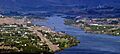
View of Rock Island, looking east up the Columbia River towards the Great Northern Railway bridge
-
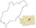
Location of Rock Island, Washington
See also
 In Spanish: Rock Island (Washington) para niños
