Ross River (Queensland) facts for kids
Quick facts for kids Ross |
|
|---|---|

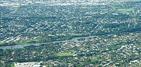
Ross River as it runs through Townsville suburbs, with Aplins Weir visible on right
|
|
|
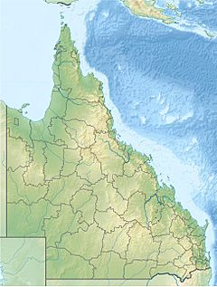
Location of Ross River river mouth in Queensland
|
|
| Country | Australia |
| State | Queensland |
| Region | North Queensland |
| City | Townsville |
| Physical characteristics | |
| Main source | Hervey Range below Pepper Pot Mountain 92 m (302 ft) 19°34′07″S 146°43′12″E / 19.56861°S 146.72000°E |
| River mouth | Coral Sea South Townsville 0 m (0 ft) 19°15′25″S 146°50′58″E / 19.25694°S 146.84944°E |
| Length | 49 km (30 mi) |
| Basin features | |
| Basin size | 1,340 km2 (520 sq mi) to 917.1 km2 (354.1 sq mi) |
| Tributaries |
|
| Reservoirs | Black Weir; Gleeson's Weir; Aplin's Weir; Ross River Dam |
The Ross River is an important river in North Queensland, Australia. It flows for about 49 kilometers (30 miles) right through the city of Townsville. The river then empties into the Coral Sea. It is the main waterway in Townsville and provides most of the city's drinking water.
The river got its name in 1864 from William Alfred Ross. He was an early settler and later became the mayor of Townsville in 1868.
Contents
River's Path and Features
The Ross River starts in the Hervey Range area, near Pepper Pot Mountain. It flows north through Lake Ross. Then it crosses a flat coastal plain and turns east around Mount Stuart into Townsville city.
The river flows through several Townsville suburbs. These include Aitkenvale, Annandale, Condon, Kelso, Mundingburra, Murray and Rasmussen. Three smaller streams, called tributaries, join the Ross River. One of these is Ross Creek. The river then reaches its mouth southeast of Townsville. This area is being developed into a marina where boats can dock.
The amount of water flowing in the river is controlled by the Ross River Dam. This is the biggest dam in the river's area. There are seven bridges that cross the river. Also, three weirs are built along the river's path. A weir is like a small dam that controls water flow. The river's catchment area, where it collects water, is about 1,340 square kilometers (517 square miles). About 102 square kilometers (39 square miles) of this area are estuarine wetlands, which are marshy areas near the coast.
Ross River Parkway: Fun and Fitness
The Ross River Parkway is a network of parks, community areas, and walking bridges. It stretches for over 30 kilometers (19 miles). The parkway links The Vickers Bridge in Douglas to Rooney's Bridge in Railway Estate. It has many shared paths for walking, running, and cycling.
Many people use the parkway for fun and exercise. It also provides a safe way to get from the Townsville central business district to the suburbs. The parkway was built over many years. The Townsville City Council and Queensland Government helped fund it. It connects many existing parks, paths, and bridges. Some well-known places in the Ross River Parkway include Riverway, Tony Ireland Stadium, The Palmetum, and various weirs.
Weirs of Ross River
Weirs are structures built across a river to control water flow or raise the water level. The Ross River has three main weirs.
Black Weir: An Old Water Source
Black Weir is the highest weir up the Ross River. It was built in the early 1930s. This weir is made of hollow supports and has a special shape to help water flow over it. Its name comes from the Black School that was near the river when the weir was built.
The weir was damaged by floods and repaired in 1934. More changes were made to help it hold more water. During World War II, many more people came to Townsville because of the military. This meant the city needed more water. In 1940, a metal wall was added to Black Weir. This helped store even more water for the town's supply.
Gleeson's Weir: The First Weir
Gleeson's Weir crosses the Ross River between the suburbs of Cranbrook and Douglas. It was the first of the three weirs built on the Ross River. It was finished in 1908. This weir was built to help secure and stabilize the water supply for local residents. It could hold about 410 million liters (108 million gallons) of water. However, water was not pumped from it until around 1923.
Aplin's Weir: Keeping Salt Water Out
Aplin's Weir is downstream from Gleeson's Weir. It is the last weir before the river reaches the sea. It started as a small stop weir in 1927. Its main job was to stop salt water from the ocean from mixing with the fresh water supply. This fresh water was pumped from wells upstream. The first stop weir was a metal wall driven into the sand. It stuck out about 1.2 meters (4 feet) above the sand.
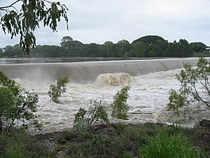
In October 1943, work began on a permanent concrete weir at this spot. It was finished in January 1944 and became known as Aplin's Weir. This weir was also damaged by floods in the 1950s and had to be repaired. In recent years, parts of the weir have worn down. It received a big upgrade in 2011.
In the late 1990s, a bridge was built connecting the suburbs of Mundingburra and Annandale. It used the base of Aplin's Weir for support. In February 2019, this bridge was washed away by floodwaters. This happened because a very large amount of water was released from the Ross River Dam during a "1 in 100-year" rain event.
The part of the river between Gleeson's Weir and Aplin's Weir is popular for water sports. The Townsville & JCU Rowing Club, a dragon boat club, kayakers, and stand-up paddle-boarders all use this section. It's also used for local rowing races.
Every year, the Townsville Open Water Association holds a swimming event called the Liz Birch memorial King and Queen of the river swim. This swim is about 2.7 kilometers (1.7 miles) long. It starts at Aplin's Weir and goes to the Barton bridge and back. The oldest person to do this swim was 79-year-old Thelma Burke. Sometimes, too many aquatic weeds in the river have stopped this event from happening as often.
Ross River Fever: A Mosquito-Borne Illness
Ross River fever is a tropical illness. It is usually not life-threatening, but it can make people feel very sick. It is caused by the Ross River virus. This virus is spread by mosquitoes.
In 1959, scientists found the virus in a type of mosquito called Aedes vigilax. This mosquito was found near the banks of the Ross River. That's how the virus and the fever got their name. However, Ross River fever is not only found near the Ross River. There have been big outbreaks of this disease in all Australian states.
River Ecosystems
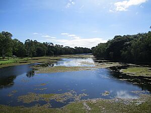
The Ross River has two very different natural environments, called ecosystems. Above Aplin's Weir, the water is fresh. This means it's a freshwater environment. Below the weir, the water is salty. This is a saltwater environment, where the river meets the sea.
 | Misty Copeland |
 | Raven Wilkinson |
 | Debra Austin |
 | Aesha Ash |


