Rothrock State Forest facts for kids
Quick facts for kids Rothrock State Forest |
|
|---|---|
|
IUCN Category VI (Managed Resource Protected Area)
|
|
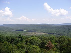
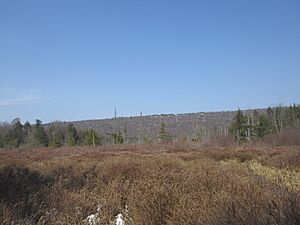
View of Bear Meadows Natural Area from the Mid State Trail.
|
|
| Location | Pennsylvania, United States |
| Area | 215,500 acres (872 km2) |
| Elevation | 1,936 ft (590 m) |
| Named for | Joseph Rothrock |
| Governing body | Pennsylvania Department of Conservation and Natural Resources |
| Website | Rothrock State Forest |
Rothrock State Forest is a huge natural area in Pennsylvania, United States. It's managed by the Pennsylvania Bureau of Forestry. The main office for the forest is in Huntingdon, which is in Huntingdon County.
This forest stretches across three different counties: Centre, Huntingdon, and Mifflin Counties. It's very popular with students and staff from Penn State University because the city of State College is only a short drive away. Rothrock State Forest also borders Bald Eagle State Forest and is close to parts of Tuscarora State Forest.
Contents
The Story of Rothrock State Forest
Why Pennsylvania's Forests Needed Help
Long ago, in the late 1800s, Pennsylvania's forests were in trouble. Companies cut down almost all the trees to get wood and iron. They used a method called clearcutting, which meant taking every tree. This left behind lots of dry branches and stumps.
Sparks from passing steam locomotives often started huge wildfires. These fires stopped new trees from growing. People worried that the forests would never grow back.
How Rothrock State Forest Began
Some smart people, called conservationists, wanted to save the forests. One of the most important was Dr. Joseph Rothrock. The forest is named after him! He believed forests needed to be managed carefully to regrow.
These conservationists asked the state to buy land from the logging and iron companies. The companies were happy to sell because they had already used up all the trees. In 1895, Dr. Rothrock became the first head of the Pennsylvania Department of Forests and Waters. This group later became today's Pennsylvania Department of Conservation and Natural Resources.
In 1897, a law was passed allowing the state to buy land for "forest reservations." This was the start of Pennsylvania's State Forest system.
Growing the Forest Back
Dr. Rothrock did two big things: he bought lots of land, and he started a school to train foresters. He helped buy about 35,000 acres (14,000 ha) of land that used to belong to an iron company. This land had been stripped bare to make charcoal for iron furnaces.
More land was bought, and soon most of the Seven Mountain area became state property. In the early 1900s, this land was split into three forest reserves: Logan, Penn, and Rothrock. In 1953, these three forests were combined. Parts of Logan and Penn went to Bald Eagle State Forest, and the rest formed what we now know as Rothrock State Forest.
Protecting the Forest from Fires
In the 1920s, some of the first fire towers in Pennsylvania were built in Rothrock State Forest. Pennsylvania Governor Gifford Pinchot helped get money to build these tall steel towers. From these towers, foresters could spot forest fires quickly.
Thanks to these towers and better forest management, the number and size of forest fires dropped a lot.
Help from the Civilian Conservation Corps
During the Great Depression, many young men worked in the forests. They were part of the Civilian Conservation Corps (CCC), a program started by President Franklin D. Roosevelt. The CCC workers cleared away dry brush that could cause fires. They also built roads, trails, and recreational areas in the state forests and parks. Many of these facilities are still used today!
Modern Forest Management
By the 1950s, the new forests of oak and hickory had grown big enough to be harvested for lumber. In 1955, a scientific plan was put in place to manage the timber. This plan grew into a full natural resource management plan in 1985.
Today, this plan helps manage water, wildlife, timber, fire protection, and recreation. More and more people are visiting Rothrock State Forest for fun. Everyone is asked to follow the rules and respect the forest.
Fun Things to Do in Rothrock State Forest
Rothrock State Forest is a great place for outdoor adventures!
Nearby State Parks to Explore
There are four Pennsylvania State Parks located right inside Rothrock State Forest:
- Greenwood Furnace State Park
- Penn-Roosevelt State Park
- Trough Creek State Park
- Whipple Dam State Park
Mountain Biking Adventures
Rothrock State Forest is one of the best places in Pennsylvania for mountain biking. You can find many trails here, from easy rides to challenging ones. Big races like the Wilderness 101 and the Trans-Sylvania Mountain Bike Epic happen here every year.
Finding Your Way on the Trails
Many bikers and hikers use a special "Rothrock Purple Lizard Map" to find their way. You can also find free maps online from the DCNR Rothrock State Forest webpage.
Hiking Trails for Everyone
The forest has almost 300 miles of hiking trails!
- The Pennsylvania Mid State Trail (MST) crosses Rothrock for about 42 miles. This trail is 326 miles long and goes all the way from Maryland to New York.
- The Standing Stone Trail (SST) also runs through Rothrock State Forest for about 16 miles.
Horseback Riding
If you love horses, you can ride them on most of Rothrock's trails and state forest roads. However, horses are not allowed on the Pennsylvania Mid State Trail (MST), Standing Stone Trail (SST), or in special Natural Areas.
Natural Areas to Discover
Rothrock State Forest has several special "Natural Areas." These places are protected to keep their unique plants and wildlife safe.
- Alan Seeger Natural Area: This area has very old trees, some nearly 1,000 years old! You can see huge Eastern white pine and Eastern hemlock trees.
- Bear Meadows Natural Area: This area protects a unique wetland called a bog. It has special trees like black spruce and balsam fir.
- Big Flat Laurel Natural Area: Here you'll find lots of beautiful mountain laurel plants.
- Detweiler Run Natural Area: This spot has more old-growth Eastern white pine and Eastern hemlock forests.
- Little Juniata Natural Area: This area features interesting rock formations.
- Rocky Ridge Natural Area: You can see exposed sandstone and limestone rocks here under an oak forest.
Wild Areas for True Wilderness
Wild Areas are even more protected, offering a true wilderness experience.
- Thickhead Mountain Wild Area: This area has very old Chestnut Oak trees, some up to 350 years old!
- Trough Creek Wild Area: Another beautiful spot for a wild adventure.
Images for kids
 | Roy Wilkins |
 | John Lewis |
 | Linda Carol Brown |


