
Ruppoldsried facts for kids
Quick facts for kids
Ruppoldsried
|
||
|---|---|---|
|
||

Ruppoldsried
Location in Switzerland

Ruppoldsried
Location in Canton of Bern
|
||
| Country | Switzerland | |
| Canton | Bern | |
| District | Seeland | |
| Area | ||
| • Total | 2.2 km2 (0.8 sq mi) | |
| Elevation | 490 m (1,610 ft) | |
| Population
(Dec 2011)
|
||
| • Total | 259 | |
| • Density | 117.7/km2 (305/sq mi) | |
| Postal code |
3251
|
|
| Surrounded by | Balm bei Messen (SO), Messen (SO), Rapperswil, Wengi | |

Ruppoldsried was a small town, also called a municipality, in Switzerland. It was located in the Seeland area of the Bern region. On January 1, 2013, Ruppoldsried joined with the nearby town of Rapperswil. This means it is no longer its own separate municipality.
Contents
History of Ruppoldsried
Ruppoldsried was first mentioned in old records in 1279. Back then, it was called Ruopolsriet.
Early Owners and Changes
During the Late Middle Ages, a family called von Ergeuw from Burgdorf owned the village. They were involved in a land dispute near the village in 1373. Before 1506, Konrad von Ergeuw sold the village to Bern.
When Bern took control, Ruppoldsried became part of the area managed by Mülchi. It was also part of a larger court area called Zollikofen.
Religion and Farming
The people of Ruppoldsried were part of the church in Messen. In the 1500s, when Messen became Protestant during the Reformation, Ruppoldsried followed.
In the 1800s, farmers in Ruppoldsried started raising dairy cows. This was in addition to their usual farming. A village dairy was built in 1884.
Modern Times
Today, Ruppoldsried and Messen share a school district. The village has regular bus service, called Postauto, connecting it to Bern and Lyss. Ruppoldsried has kept its rural feel. Almost two-thirds of all jobs there are still in farming.
Geography of Ruppoldsried
Ruppoldsried covered an area of about 2.2 square kilometers. A large part of this land, about 79.1%, was used for farming. About 12.3% was covered by forests.
Land Use
About 5.9% of the land had buildings or roads. A small part, 1.8%, included rivers or lakes. Most of the built-up area was for houses and other buildings. The rest was for transportation like roads. All the forested land was covered with thick forests. For farming, most of the land was used for growing crops. The rest was used for pastures where animals could graze. All the water in the area was flowing water, like rivers.
Location and Nearby Areas
Ruppoldsried was located in the Limpach valley. It was right on the border with the Canton of Solothurn. The municipality included the main village of Ruppoldsried. It also included a part of a settlement called Eichholz. The other part of Eichholz belongs to the municipality of Messen in Solothurn.
In 2010, Ruppoldsried joined a new administrative district called Verwaltungskreis Seeland.
Coat of Arms
The coat of arms for Ruppoldsried has a special design. It shows a red lion walking on a gold background at the top. Below that, there is a silver castle with battlements on a blue background.
People of Ruppoldsried (Demographics)
In 2011, Ruppoldsried had a population of 259 people. A small number, about 2.7%, were foreign nationals. Over ten years, the population changed only a little.
Languages and Backgrounds
Most people in Ruppoldsried speak German. In 2000, about 98% spoke German as their main language. A few people spoke French or Portuguese.
In 2008, the population was almost evenly split between men and women. Most residents were Swiss. Many people were born in Ruppoldsried or in the same region.
Age Groups and Families
In 2010, about 25.4% of the population were children and teenagers (0-19 years old). Adults (20-64 years old) made up 66.2%. Seniors (over 64 years old) were 8.5% of the population.
In 2000, there were many single people and married couples. There were also some widows, widowers, and divorced individuals. Most apartments in Ruppoldsried were lived in all the time.
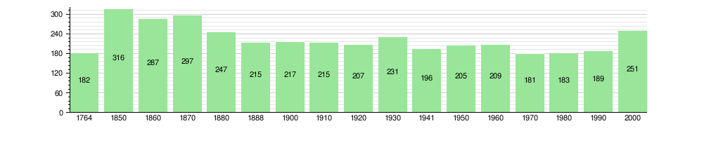
The chart below shows how the population of Ruppoldsried has changed over time:
Economy of Ruppoldsried
In 2011, the unemployment rate in Ruppoldsried was very low, at 1.08%. This means almost everyone who wanted a job had one.
Jobs and Industries
In 2008, 47 people worked in the municipality.
- Primary sector: 30 people worked in farming. This sector includes jobs like growing crops and raising animals. There were about 12 businesses in this area.
- Secondary sector: 7 people worked in this sector. This includes jobs like manufacturing (making things) and construction (building things). There were 3 businesses here.
- Tertiary sector: 10 people worked in this sector. This includes jobs that provide services, like hotels, restaurants, and education. There were 3 businesses in this area.
Many people who lived in Ruppoldsried worked outside the municipality. In 2000, 105 people traveled to other places for work. Most people used a private car to get to work.
Religion in Ruppoldsried
Based on a 2000 survey, most people in Ruppoldsried belonged to the Swiss Reformed Church. About 86.5% were part of this church. A smaller group, about 6.8%, were Roman Catholic. A few people belonged to other Christian churches or other religions. Some people did not belong to any church.
Education in Ruppoldsried
Many people in Ruppoldsried have completed higher levels of education. About 40.6% have finished non-mandatory upper secondary education. This is like high school. About 8.8% have completed even higher education, such as university.
School System
The school system in the Canton of Bern works like this:
- One year of non-required Kindergarten.
- Six years of Primary school.
- Three years of lower Secondary school. Students are grouped by their abilities.
After lower Secondary school, students can continue their education or start an apprenticeship (learning a trade).
During the 2010–2011 school year, 19 students attended classes in Ruppoldsried. There were no kindergarten classes. The municipality had 2 primary classes with 19 students.
In 2000, most students from Ruppoldsried went to schools outside the municipality.
Images for kids
-
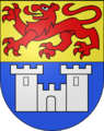
The coat of arms of Ruppoldsried.
See also
 In Spanish: Ruppoldsried para niños
