Sac County, Iowa facts for kids
Quick facts for kids
Sac County
|
|
|---|---|

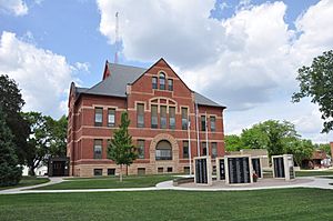
Sac County Courthouse
|
|

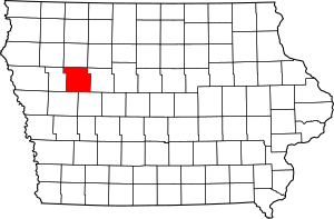
Location within the U.S. state of Iowa
|
|
 Iowa's location within the U.S. |
|
| Country | |
| State | |
| Founded | January 15, 1851 |
| Named for | Sac and Fox Nation |
| Seat | Sac City |
| Largest city | Sac City |
| Area | |
| • Total | 578 sq mi (1,500 km2) |
| • Land | 575 sq mi (1,490 km2) |
| • Water | 3.3 sq mi (9 km2) 0.6% |
| Population
(2020)
|
|
| • Total | 9,814 |
| • Density | 16.979/sq mi (6.556/km2) |
| Time zone | UTC−6 (Central) |
| • Summer (DST) | UTC−5 (CDT) |
| Congressional district | 4th |
Sac County is a county in the state of Iowa, USA. A county is like a smaller region within a state. In 2020, about 9,814 people lived here. The main town, or county seat, is Sac City. Both the county and the town are named after the Sauk people, who were a Native American tribe living in the area.
In 2007, Progressive Farmer magazine said Sac County was one of the "Best Places to Live in Rural America." It was ranked #7 overall. In 2009, the same magazine called it the tenth "Best Place" in the Midwest region.
Contents
History of Sac County
The story of Sac County began a long time ago. On January 13, 1846, the government of the Iowa Territory decided to create twelve new counties. This brought the total number of counties in the territory to 22.
Later that year, Iowa became a state on December 28, 1846. As the state grew, the original counties were too big. So, on January 15, 1851, the Iowa General Assembly created 43 more counties. Sac County was one of these new counties. It was named after the Sauk people, who were sometimes called the Sac Indians.
It took a few years for the county to get fully organized. Sac City was chosen as the county seat in 1856. The first building for the county government, called a courthouse, was finished in 1862. But the county grew quickly! By 1873, they needed a bigger courthouse.
A new, larger courthouse with a tall bell tower was ready in January 1874. Sadly, it burned down in 1888. The courthouse that stands today was built to replace it. It was updated and made bigger in the 1980s.
Geography and Location
Sac County covers about 578 square miles. Most of this area, about 575 square miles, is land. The rest, about 3.3 square miles, is water.
Main Roads in Sac County
You can travel through Sac County on several important roads:
 U.S. Highway 20: This road goes from east to west through the northern part of the county. It passes through Early and north of Sac City.
 U.S. Highway 71: This road starts near Sac City and goes south. It turns east for a few miles near Auburn, then continues south into Carroll County.
 Iowa Highway 39: This road starts at Odebolt and goes south into Crawford County.
 Iowa Highway 110: This road starts at U.S. Highway 20 and goes north into Buena Vista County.
 Iowa Highway 175: This road enters the county on the west side at Odebolt. It goes east to where it meets U.S. Highway 71, east of Lake View.
Neighboring Counties
Sac County shares its borders with these other counties:
- Buena Vista County – to the north
- Calhoun County – to the east
- Carroll County – to the south and southeast
- Cherokee County – to the northwest
- Crawford County – to the south and southwest
- Ida County – to the west
- Pocahontas County - to the northeast
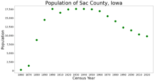
Population Changes Over Time
| Historical population | |||
|---|---|---|---|
| Census | Pop. | %± | |
| 1860 | 246 | — | |
| 1870 | 1,411 | 473.6% | |
| 1880 | 8,774 | 521.8% | |
| 1890 | 14,522 | 65.5% | |
| 1900 | 17,639 | 21.5% | |
| 1910 | 16,555 | −6.1% | |
| 1920 | 17,500 | 5.7% | |
| 1930 | 17,641 | 0.8% | |
| 1940 | 17,639 | 0.0% | |
| 1950 | 17,518 | −0.7% | |
| 1960 | 17,007 | −2.9% | |
| 1970 | 15,573 | −8.4% | |
| 1980 | 14,118 | −9.3% | |
| 1990 | 12,324 | −12.7% | |
| 2000 | 11,529 | −6.5% | |
| 2010 | 10,350 | −10.2% | |
| 2020 | 9,814 | −5.2% | |
| 2023 (est.) | 9,686 | −6.4% | |
| U.S. Decennial Census 1790-1960 1900-1990 1990-2000 2010-2018 |
|||
What the 2020 Census Showed
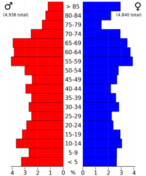
The 2020 census counted 9,814 people living in Sac County. This means there were about 17 people for every square mile. Most people (97.09%) said they were of one race. About 90.86% were non-Hispanic White. Other groups included Black, Hispanic, Native American, Asian, and Native Hawaiian or Pacific Islander people. Some people were also of more than one race. There were 5,118 homes in the county, and 4,273 of them were lived in.

What the 2010 Census Showed
The 2010 census recorded 10,350 people in the county. There were 5,429 homes, and 4,482 of them were lived in.
Education in Sac County
Several school districts serve the students in Sac County:
- Alta-Aurelia Community School District
- East Sac County Community School District
- Galva-Holstein Community School District
- Newell-Fonda Community School District
- Odebolt Arthur Battle Creek Ida Grove Community School District
- Schaller-Crestland Community School District
- South Central Calhoun Community School District
- Storm Lake Community School District
Three of these districts are mainly in Sac County. The East Sac County School District (ESC) is the biggest. The Schaller-Crestland School District serves the northwest part of the county. The Odebolt-Arthur School District serves the southwest part. Students from these districts can graduate from East Sac County High School, OA-BCIG High School, or Ridge View High School. Only East Sac County High School is located within Sac County.
Some parts of Sac County are also served by the South Central Calhoun School District, especially around Lytton. A small area in the northwest is part of the Galva–Holstein Community School District.
Geocaching Fun
Sac County is a great place for geocaching! Geocaching is like a treasure hunt using GPS. In 2011, geocachers made Sac County famous by hiding a series of caches (the "treasures") in a special pattern. They spelled out "SAC" along rural roads between Sac City and Lytton. It was a mile wide and 8 miles tall!
Towns and Communities
Cities in Sac County
Unincorporated Community
- Carnarvon (This is a small community that is not officially a city or town.)
Townships
Counties are often divided into smaller areas called townships. Here are the townships in Sac County:
- Boyer Valley
- Cedar
- Clinton
- Cook
- Coon Valley
- Delaware
- Douglas
- Eden
- Eureka
- Jackson
- Levey
- Richland
- Sac
- Viola
- Wall Lake
- Wheeler
Population Ranking of Cities
This table shows the cities in Sac County, ranked by how many people lived there in the 2020 census.
† This symbol means it's the county seat.
| Rank | City/Town/etc. | Type | Population (2020 Census) |
|---|---|---|---|
| 1 | † Sac City | City | 2,063 |
| 2 | Lake View | City | 1,113 |
| 3 | Odebolt | City | 994 |
| 4 | Wall Lake | City | 755 |
| 5 | Schaller | City | 729 |
| 6 | Early | City | 587 |
| 7 | Auburn | City | 265 |
| 8 | Lytton (partly in Calhoun County) | City | 242 (282 total) |
| 9 | Nemaha | City | 66 |
See also
 In Spanish: Condado de Sac para niños
 | William M. Jackson |
 | Juan E. Gilbert |
 | Neil deGrasse Tyson |


