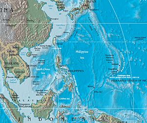
Saikaidō Seamounts -- northern part of Kyushu-Palau Ridge on ocean floor of Philippine Sea
The Saikaidō Seamounts are a group of underwater mountains found in the Philippine Sea. These special mountains are at the northern end of a long underwater chain called the Kyushu-Palau Ridge. This ridge starts about 900 kilometers (about 560 miles) from the eastern part of the Bungo Channel in Japan.
The Bungo Channel is a strait between the Japanese islands of Kyushu and Shikoku. From there, the Kyushu-Palau Ridge stretches southwest towards Palau. Along this underwater line, you'll find a chain of extinct volcanoes. This means they are volcanoes that are no longer active.
The Saikaidō underwater mountain chain is located southeast of the Japanese island of Kyushu. It gets its name from Saikaidō, which was the name for a southern region of Japan a long time ago, during the Asuka period.
What Are Seamounts?
Each of the Saikaidō Seamounts is an underwater volcano that is no longer active. They are like mountains hidden beneath the ocean's surface. This undersea mountain range includes several named seamounts:
| Name |
Japanese Name |
Location |
| Bungo Seamount |
豊後海山 |
Named after the old Bungo Province in the Saikaidō region. |
| Buzen Seamount |
豊前海山 |
Named after the old Buzen Province in the Saikaidō region. |
| Chikugo Seamount |
筑後海山 |
Named after the old Chikugo Province in the Saikaidō region. |
| Chikuzen Seamount |
筑前海山 |
Named after the old Chikuzen Province in the Saikaidō region. |
| Higo Seamount |
肥後海山 |
Named after the old Higo Province in the Saikaidō region. |
| Hizen Seamount |
肥前海山 |
Named after the old Hizen Province in the Saikaidō region. |
| Komahashi Seamount |
駒橋海山 |
Named after an old area called Komahashi in the Saikaidō region. |
| Komahashi-daini Seamount |
駒橋第二海山 |
Also named after the old Komahashi area. |
| Nishinoomote Seamount |
西之表海山 |
Named after the old Nihinoomote area in the Saikaidō region. |
| Osumi Seamount |
大隅海山 |
Named after the old Ōsumi Province in the Saikaidō region. |
| Satsuma Seamount |
薩摩海山 |
Named after the old Satsuma Province in the Saikaidō region. |
Related Ocean Features


