
Salgesch facts for kids
Quick facts for kids
Salgesch
|
||
|---|---|---|
 |
||
|
||

Salgesch
Location in Switzerland

Salgesch
Location in Canton of Valais
|
||
| Country | Switzerland | |
| Canton | Valais | |
| District | Leuk | |
| Area | ||
| • Total | 11.36 km2 (4.39 sq mi) | |
| Elevation | 581 m (1,906 ft) | |
| Population
(Dec 2020 )
|
||
| • Total | 1,567 | |
| • Density | 137.94/km2 (357.26/sq mi) | |
| Postal code |
3970
|
|
| Surrounded by | Chandolin, Leuk, Miège, Mollens, Sierre, Varen, Veyras | |

Salgesch (French: Salquenen) is a charming village in Switzerland. It's located in the beautiful Valais region, known for its stunning mountains and sunny weather. Salgesch is especially famous for its delicious wines, and it's a great place to learn about how wine is made! It is part of the Leuk district.
Contents
A Look Back in Time
Salgesch has a long history! It was first mentioned way back in the 11th century. For many years, Salgesch was mainly a farming village.
After World War II, things started to change. The village began to focus more on growing grapes and making wine. Today, Salgesch has over 200 hectares (about 500 acres) of vineyards. It is home to more than forty wineries!
Understanding the Coat of Arms
The village of Salgesch has its own special symbol, called a coat of arms. It shows a black shield with a silver cross. This cross is known as a Maltese Cross.
The Maltese Cross on the coat of arms reminds everyone of the Knights of St. John of Malta. These knights were a group of people who helped pilgrims and travelers. In the 13th century, some of these knights settled in Salgesch. They built a place for travelers to stay. The Knights of St. John lived in Salgesch for about 400 years.
Exploring Salgesch's Geography

Salgesch covers an area of about 11.3 square kilometers (4.4 square miles). A large part of this land, about half, is covered by forests. About one-fifth of the land is used for farming, especially for vineyards.
The village itself, with its buildings and roads, takes up about 10% of the land. There are also rivers and lakes, and some areas that are rocky or have wild plants.
Salgesch is located in the Leuk district. It sits on the right side of the Rhone valley. It's special because it's the westernmost village in Valais where people mainly speak German.
A small water channel, built a long time ago in medieval times, runs through the village. People in Salgesch call it the Mengis-Wasserleitu or Bisse de Mengis.
Who Lives in Salgesch?


Salgesch is home to about 1,258 people. Most people in Salgesch speak German. This is their main language. Some people also speak French, and a smaller number speak Italian.
Many people who live in Salgesch were born there. Others were born in the same canton (Valais) or in other parts of Switzerland. A small number of people were born outside of Switzerland.
The population includes children and teenagers (up to 19 years old), adults (20-64 years old), and seniors (over 64 years old). About two-thirds of the people are adults.
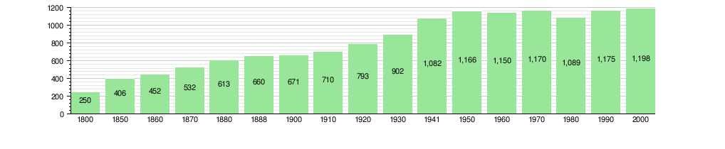
The number of people living in Salgesch has changed over time. You can see how the population has grown and changed in the chart below:
Salgesch's Economy
Salgesch has a healthy economy with many different types of jobs. In 2010, the unemployment rate was low.
Many people work in the primary sector, which includes farming. This is especially true for grape growing and wine production.
The secondary sector involves making things. In Salgesch, this includes manufacturing and construction.
The tertiary sector is about services. This includes jobs in shops, restaurants, and transportation. Many people also work in education or as technical professionals.
Most people who work in Salgesch use a private car to get to their jobs. Some also use public transportation.
Religious Life in Salgesch
Most people in Salgesch are Roman Catholic. A smaller number belong to the Swiss Reformed Church. There are also a few people who are members of an Orthodox church or other Christian churches.
Some people in Salgesch follow the Islamic faith. A very small number are Buddhist. There are also people who do not belong to any church.
Learning and Education
In Salgesch, many adults have completed their high school education. Some have gone on to get even higher education from a university or a specialized college.
The school system in Valais starts with a non-required year of Kindergarten. After that, students attend six years of primary school. Salgesch has kindergarten and primary school classes.
After primary school, students go to secondary school. These schools are in nearby villages. Students from Salgesch travel to these schools for their middle and high school education.
Grand Cru de Salquenen: A Special Wine
Salgesch is famous for a very special wine called Grand Cru de Salquenen. This wine is only made in this village.
The wine producers in Salgesch are very strict about how this wine is made. They limit how many grapes can be grown per square meter. This helps make sure the grapes are of the best quality.
The grapes for Grand Cru wine must be very sweet. Also, only grapes grown using special, environmentally friendly methods can be used. It is not allowed to add sugar to the wine or mix it with other wines. The wine also cannot be aged in barrels.
After the wine is made, it must stay in the producers’ cellars for at least 15 months. Then, a special group of experts tastes the wine. To be called Grand Cru, the wine must get a very high score. If it passes, it gets a special golden label from the village of Salquenen.
Fun Things to Do in Salgesch
There are many activities in and around Salgesch, especially if you love wine!
- You can walk along a wine trail to see the vineyards.
- Visit the Green Lizard or Domaine de la Doline. This is a special area where landowners protect rare plants and endangered animals.
- Attend wine symposiums to learn more about wine.
- Go to VINEA, which is a big meeting for Valaisan wines.
- Take part in vine to the cellar activities. These teach you all the steps involved in turning grapes into delicious wine!
Images for kids
-
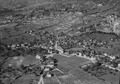
Aerial view (1955)
See also
 In Spanish: Salgesch para niños
