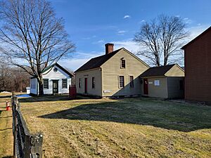
Salmon Brook, Connecticut facts for kids
Quick facts for kids
Salmon Brook, Connecticut
|
|
|---|---|

Salmon Brook Historical Society
|
|
| Country | United States |
| State | Connecticut |
| County | Hartford |
| Town | Granby |
| Area | |
| • Total | 3.0 sq mi (7.8 km2) |
| • Land | 3.0 sq mi (7.8 km2) |
| • Water | 0 sq mi (0 km2) |
| Elevation | 215 ft (66 m) |
| Population
(2010)
|
|
| • Total | 2,324 |
| • Density | 772/sq mi (297.9/km2) |
| Time zone | UTC-5 (Eastern) |
| • Summer (DST) | UTC-4 (Eastern) |
| ZIP code |
06035
|
| Area code(s) | 860 |
| FIPS code | 09-66455 |
| GNIS feature ID | 2377858 |
Salmon Brook is a special area in Granby, a town in Connecticut, USA. It's known as a 'census-designated place' (CDP). This means it's a specific area that the government counts for population. Salmon Brook is the main village within the town of Granby. In 2010, about 2,324 people lived there.
Contents
Exploring Salmon Brook's Location and Features
Salmon Brook is named after a stream that flows east of Granby village. This stream eventually joins the Farmington River to the south. Another part, the West Branch of Salmon Brook, flows south of the village. The village itself sits on a flat area about 50 feet (15 meters) above the stream valleys.
Understanding Salmon Brook's Size
The United States Census Bureau says that Salmon Brook covers a total area of about 7.8 square kilometers (3.0 square miles). All of this area is land, with no water within its boundaries.
Major Roads and Connections in Salmon Brook
Salmon Brook is a central spot where several important roads meet. U.S. Route 202 and Connecticut Route 10 run through the village from north to south. These roads connect Salmon Brook to Westfield, Massachusetts in the north and Simsbury in the south.
Connecticut Route 20 goes through the village from east to west. It leads east to Bradley International Airport and Windsor Locks. To the west, it goes towards Winsted.
Connecticut Route 189 heads northwest from Salmon Brook to Granville, Massachusetts. It also goes southeast through Tariffville and Bloomfield to Hartford. All these main roads come together at the Granby Green, which is right in the middle of the village.
Who Lives in Salmon Brook?
In the year 2000, there were 2,453 people living in Salmon Brook. These people lived in 988 households, and 672 of these were families. The area had about 827 people per square mile (319 people per square kilometer).
Diversity in Salmon Brook
Most people living in Salmon Brook in 2000 were White (98.08%). A smaller number were African American (0.24%), Native American (0.16%), or Asian (0.49%). About 1.14% of the population identified as Hispanic or Latino.
Households and Families
Out of all the households, about 32.2% had children under 18 living with them. Most households (58.2%) were married couples living together. About 7.7% were single mothers with no husband present. Around 26.9% of households were people living alone.
Age Groups in Salmon Brook
The population of Salmon Brook includes people of all ages. About 23.7% of the people were under 18 years old. Around 29.9% were between 25 and 44 years old. About 18.8% of the people were 65 years old or older. The average age in Salmon Brook was 41 years.
Income and Economy
In 2000, the average income for a household in Salmon Brook was $67,500 per year. For families, the average income was $80,945. The average income per person was $32,311. A small number of families (3.1%) and people (6.0%) lived below the poverty line. This included 10.0% of those under 18 and 7.3% of those 65 or older.
See also
 In Spanish: Salmon Brook para niños
 | James Van Der Zee |
 | Alma Thomas |
 | Ellis Wilson |
 | Margaret Taylor-Burroughs |


